


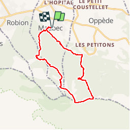

16.7 km | 27 km-effort

User


FREE GPS app for hiking
 SityTrail
IGN / Geographical institutes
SityTrail World
The world is yours!
Trail Walking of 15 km to be discovered at Provence-Alpes-Côte d'Azur, Vaucluse, Maubec. This trail is proposed by GerardBouche.
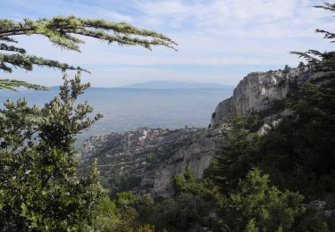
Une mise en jambe par un petit sentier ombragé par le chêne vert dans la "Combe de St-Pierre " avant d'entamer une montée dans la " Combe de Combrès " avec des passages caillouteux et abruptes mais aussi un passage étroit et "aérien" à flanc de rocher (mieux vaut ne pas avoir le vertige). Depuis le plateau du "Petit Luberon" descendre par le "Sommet des Fourcats" et le sentier de la "Draille des frères Nouguier".Une randonnée entre falaises et vallons, buis et chênes verts(Yeuse), qui nécessite de bonnes chaussures, des bâtons et ... un bon sens de l'équilibre !
 - Photo 1")
 - Photo 2")
 - Photo 3")
 - Photo 4")
 - Photo 5")
 - Photo 6")
 - Photo 7")
 - Photo 8")
 - Photo 9")
 - Photo 10")
 - Photo 11")
 - Photo 12")

Walking
Walking

Walking

Walking

Walking

Mountain bike

Walking

Walking
Mountain bike