Tocht Stappen Planès - Étang Planes - Photo
 Merlos
Merlos

Gebruiker

© OpenStreetMap contributors
Lengte
Lengte
11,4 km
Boucle
Boucle
Ja
Datum van aanmaak :
2019-05-31 09:44:09.858
Laatste wijziging :
2019-05-31 15:50:06.06

(0 Bericht)

Stappen
Stappen
4h38
Moeilijkheid : Gemakkelijk

Scan deze QR-code om de tocht te openen in de SityTrail-applicatie

Gratisgps-wandelapplicatie

Logo SityTrail SityTrail

IGN / Geografische instituten

SityTrail uit de App Store downloaden SityTrail uit Google Play downloaden

Logo SityTrail SityTrail World

De wereld gaat voor u open

SityTrail uit de App Store downloaden SityTrail uit Google Play downloaden SityTrail op Huawei AppGallery downloaden

Over ons

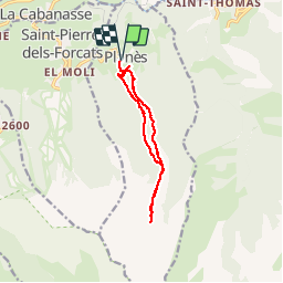
Tocht Stappen van 11,4 km beschikbaar op Occitanië, Pyrénées-Orientales, Planès. Deze tocht wordt voorgesteld door Merlos.

Beschrijving

très belle rando rafraîchissante (ruisseau, étang) la montée est à l'ombre ce qui n'est pas négligeable quand il fait chaud...

Hoogteprofiel

Foto's

Plaatsbepaling

Land:
France
Regio :
Occitanië
Departement/Provincie :
Pyrénées-Orientales
Gemeente :
Planès
Locatie:
Unknown
Vertrek:(UTM)
429213 ; 4704648 (31T) N.

Wandeltochten in de omgeving

Tocht Stappen Eyne - Eyne,col de Nuria,pic d'Eyne,Torre d'Eyne,Eyne. - Photo
Stappen
Machaon6

Stappen

Zeer moeilijk
(1)
Eyne, Occitanië, Pyrénées-Orientales, France
24 km | 43 km-effort
8h 44min
Ja
Tocht Stappen Fontpédrouse - Tour du Cucurucull - Photo
Stappen
Pek56

Stappen

Medium
(1)
Fontpédrouse, Occitanië, Pyrénées-Orientales, France
9,3 km | 18,5 km-effort
3h 24min
Ja
Tocht Stappen Planès - étang de Planès - Photo
Stappen
fhascoet

Stappen

Medium
(2)
Planès, Occitanië, Pyrénées-Orientales, France
10,8 km | 19,6 km-effort
3h 54min
Neen
Tocht Stappen Fontpédrouse - fontpérouse sentier des canaux et sources chaudes naturelles_T - Photo
Stappen
force

Stappen

Medium
(1)
Fontpédrouse, Occitanië, Pyrénées-Orientales, France
13,7 km | 25 km-effort
5h 9min
Ja
Tocht Stappen Eyne - Le Cambre d'Ase - Photo
Stappen
tracegps

Stappen

Moeilijk
(1)
Eyne, Occitanië, Pyrénées-Orientales, France
8,9 km | 22 km-effort
4h 0min
Ja
Tocht Stappen Eyne - Vallée d'Eyne - Photo
Stappen
GUIDE
nadinebondoux

Stappen

Medium
Eyne, Occitanië, Pyrénées-Orientales, France
10,7 km | 17,6 km-effort
4h 40min
Ja
Tocht Stappen Saint-Pierre-dels-Forcats - bains  de St Thomas  - Photo
Stappen
Ptitjack30

Stappen

Medium
(1)
Saint-Pierre-dels-Forcats, Occitanië, Pyrénées-Orientales, France
8,6 km | 12,2 km-effort
2h 42min
Neen
Tocht Stappen La Llagonne - llagonne - Calvet - Photo
Stappen
merencianoep

Stappen

Medium
(2)
La Llagonne, Occitanië, Pyrénées-Orientales, France
11,2 km | 14,2 km-effort
3h 0min
Neen
Tocht Stappen Eyne - eyne - Photo
Stappen
gardelg

Stappen

Medium
(2)
Eyne, Occitanië, Pyrénées-Orientales, France
6,2 km | 8,2 km-effort
2h 1min
Ja


Sluiten
Mijn abonnementen