Trail Mountain bike Munster - Circuit des Vallons - Munster - Photo

Circuit des Vallons - Munster

 tracegps
tracegps

User

© OpenStreetMap contributors
Length
Length
44 km
Max alt
Max alt
918 m
Uphill gradient
Uphill gradient
1205 m
Km-Effort
Km-Effort  
60 km
Min alt
Min alt
304 m
Downhill gradient
Downhill gradient
1207 m
Boucle
Boucle
Yes
Creation date :
2014-12-10 00:00:00.0
Updated on :
2014-12-10 00:00:00.0

(0 Reviews)

Mountain bike
Mountain bike
4h00
Difficulty : Very difficult

Scan this QR Code to open this trail in the SityTrail application

FREE GPS app for hiking

Logo SityTrail SityTrail

IGN / Geographical institutes

Download SityTrail from the App Store Download SityTrail from Google Play

Logo SityTrail SityTrail World

The world is yours!

Download SityTrail from the App Store Download SityTrail from Google Play Download SityTrail on Huawei AppGallery

About

Trail Mountain bike of 44 km to be discovered at Grand Est, Haut-Rhin, Munster. This trail is proposed by tracegps.

Description

Ce circuit ne présente pas de difficultés techniques. Seule la montée entre le cimetière militaire et l'embranchement vers la ferme-auberge de Laymersberg est longue. La descente depuis le col de Marbach jusqu'à la gare de Wihr-au-Val est roulante. Attention toutefois à l'embranchement sis après le contour du Stumpfenkopf, car on ne voit pas bien la balise située en contrebas sur un arbre..... La suite et une carte détaillée sont ICI

Elevation profile

Photos

Positioning

Country:
France
Region :
Grand Est
Department/Province :
Haut-Rhin
Municipality :
Munster
Location:
Unknown
Start:(UTM)
360812 ; 5322280 (32U) N.

Comments

Please log in to post a review or rate the element
 

Trails nearby

Trail Walking Munster - De Munster aux 3 Fours (Aller) - Munster - Photo
Walking
tracegps

Walking

Difficult
(1)
Munster, Grand Est, Haut-Rhin, France
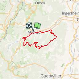
14.8 km | 27 km-effort
5h 0min
No
Trail Walking Hohrod - Circuit historique 1914-18 Hohrodberg - Linge - Photo
Walking
VacheKiri67

Walking

Medium
(1)
Hohrod, Grand Est, Haut-Rhin, France
14 km | 19.8 km-effort
5h 50min
Yes
Trail Walking Munster - 19.06.13.Munster  - Photo
Walking
ROPPJP

Walking

Very easy
(1)
Munster, Grand Est, Haut-Rhin, France
7.3 km | 10.6 km-effort
2h 10min
Yes
Trail Mountain bike Metzeral - Sentier des Névés - Photo
Mountain bike
tracegps

Mountain bike

Very difficult
(1)
Metzeral, Grand Est, Haut-Rhin, France
33 km | 52 km-effort
6h 0min
Yes
Trail Horseback riding Gunsbach - Le petit Hohnack - verkort (23) - Photo
Horseback riding
eddyvermeulen1

Horseback riding

Easy
(1)
Gunsbach, Grand Est, Haut-Rhin, France
13.1 km | 18.4 km-effort
2h 25min
Yes
Trail Walking Soultzeren - 2022-12-27 Marche Soultzeren Lac Forlet Hautes Huttes Glasborn - Photo
Walking
GUIDE
holtzv

Walking

Very difficult
Soultzeren, Grand Est, Haut-Rhin, France
21 km | 34 km-effort
5h 47min
Yes
Trail Horseback riding Stosswihr - 2018-08-26 Picnic CVA Cascades Stosswihr - Photo
Horseback riding
GUIDE
holtzv

Horseback riding

Easy
Stosswihr, Grand Est, Haut-Rhin, France
19.2 km | 29 km-effort
3min
Yes
Trail Walking Hohrod - Hohrodberg - Le Linge - Photo
Walking
sit68000

Walking

Easy
(2)
Hohrod, Grand Est, Haut-Rhin, France
6.5 km | 10.3 km-effort
2h 2min
Yes
Trail Walking Wasserbourg - Autour de Wasserbourg - Photo
Walking
bob68

Walking

Easy
(1)
Wasserbourg, Grand Est, Haut-Rhin, France
8.8 km | 14 km-effort
2h 6min
Yes


Close
My subscriptions