Trail Mountain bike Kintzheim - Le Haut Koenigsbourg - Photo

Le Haut Koenigsbourg

 tracegps
tracegps

User

© OpenStreetMap contributors
Length
Length
12.8 km
Max alt
Max alt
731 m
Uphill gradient
Uphill gradient
543 m
Km-Effort
Km-Effort  
20 km
Min alt
Min alt
207 m
Downhill gradient
Downhill gradient
542 m
Boucle
Boucle
Yes
Creation date :
2014-12-10 00:00:00.0
Updated on :
2014-12-10 00:00:00.0

(0 Reviews)

Mountain bike
Mountain bike
3h00
Difficulty : Medium

Scan this QR Code to open this trail in the SityTrail application

FREE GPS app for hiking

Logo SityTrail SityTrail

IGN / Geographical institutes

Download SityTrail from the App Store Download SityTrail from Google Play

Logo SityTrail SityTrail World

The world is yours!

Download SityTrail from the App Store Download SityTrail from Google Play Download SityTrail on Huawei AppGallery

About

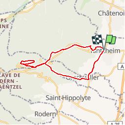
Trail Mountain bike of 12.8 km to be discovered at Grand Est, Bas-Rhin, Kintzheim. This trail is proposed by tracegps.

Description

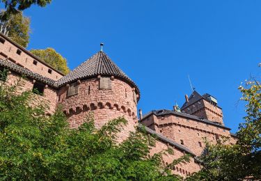
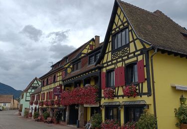
Balade proposée par « Alsace en randonnée.» Le départ s'effectue devant la mairie. Un chemin forestier balisé rectangle rouge-blanc-rouge conduit au Schaflaeger. Traverser la route au niveau du pylône pour arriver à l"'Hôtel du Haut-Koenigsbourg". Le sentier de Grande Randonnée permet d'atteindre le château. A droite de la buvette, suivre le sentier rectangle rouge-blanc-rouge pour rejoindre le sentier de Grande Randonnée 5. Le quitter à la borne hexagonale. Reprendre le balisage rouge-blanc-rouge, traverser la Dl 59, puis passer à côté de l'étang de pèche qui se situe à proximité du château de Kintzheim. Descendre au village de Kintzheim, le traverser et prendre vers la droite la D 35. A la sortie du village, le chemin balisé chevalet bleu ramène à Orschwiller en traversant le vignoble. Remarques ; le château de Kintzheim, construit à l'époque médiévale, abrite aujourd'hui la Volerie des Aigles. On y accède à partir de l'étang de pêche. Remonter la route, puis dans le virage, suivre le chemin forestier qui conduit au château. Balisage : la plupart des sentiers dans la montagne vosgienne sont tracés, entretenus et balisés bénévolement par les membres du Club Vosgien, d'une façon tout à fait remarquable. Les différents signes en couleur (rectangle, disque, triangle, croix, etc...) sont reproduits sur la carte.

Elevation profile

Photos

Positioning

Country:
France
Region :
Grand Est
Department/Province :
Bas-Rhin
Municipality :
Kintzheim
Location:
Unknown
Start:(UTM)
380885 ; 5345862 (32U) N.

Trails nearby

Trail Walking Châtenois - Le Hahnenberg et les balcons Sélestat - Photo
Walking
VacheKiri67

Walking

Medium
(2)
Châtenois, Grand Est, Bas-Rhin, France
12 km | 17.2 km-effort
4h 29min
Yes
Trail Walking Sélestat - Sentier de l'Illwald - Photo
Walking
tracegps

Walking

Medium
(1)
Sélestat, Grand Est, Bas-Rhin, France
13.2 km | 14.6 km-effort
3h 45min
Yes
Trail Walking Châtenois - Le Haut Koenigsbourg de Val de Ville - Photo
Walking
tracegps

Walking

Difficult
(1)
Châtenois, Grand Est, Bas-Rhin, France
16.8 km | 25 km-effort
5h 0min
Yes
Trail Walking Kintzheim - suuntoapp-Hiking-2023-10-15T07-53-44Z - Photo
Walking
GUIDE
holtzv

Walking

Medium
Kintzheim, Grand Est, Bas-Rhin, France
18.5 km | 28 km-effort
6h 16min
Yes
Trail Walking Saint-Hippolyte - St hippolyte ht koenigsbourg - Photo
Walking
legereric

Walking

Medium
(2)
Saint-Hippolyte, Grand Est, Haut-Rhin, France
12 km | 18.7 km-effort
3h 27min
Yes
Trail Walking Scherwiller - chateau  de ortenbourg - Photo
Walking
dudu42

Walking

Very easy
(1)
Scherwiller, Grand Est, Bas-Rhin, France
4.6 km | 7.9 km-effort
1h 29min
Yes
Trail Walking Saint-Hippolyte - St-Hippolyte - Rorschwihr - Grasberg - Bergheim - Reichenberg - Rodern - Photo
Walking
VacheKiri67

Walking

Medium
Saint-Hippolyte, Grand Est, Haut-Rhin, France
17.3 km | 22 km-effort
4h 28min
Yes
Trail Walking Sélestat - Sélestat : balade dans le Ried - Photo
Walking
Bart2015

Walking

Difficult
Sélestat, Grand Est, Bas-Rhin, France
11.4 km | 12.6 km-effort
2h 51min
Yes
Trail Electric bike Sélestat - Vignoble  - Photo
Electric bike
apa

Electric bike

Very easy
Sélestat, Grand Est, Bas-Rhin, France
50 km | 57 km-effort
3h 4min
No


Close
My subscriptions