Trail Mountain bike Scherwiller - VTT autour du Bernstein - Scherwiller - Photo

VTT autour du Bernstein - Scherwiller

 tracegps
tracegps

User

© OpenStreetMap contributors
Length
Length
25 km
Max alt
Max alt
659 m
Uphill gradient
Uphill gradient
800 m
Km-Effort
Km-Effort  
36 km
Min alt
Min alt
185 m
Downhill gradient
Downhill gradient
799 m
Boucle
Boucle
Yes
Creation date :
2014-12-10 00:00:00.0
Updated on :
2014-12-10 00:00:00.0

(1 Reviews)

Mountain bike
Mountain bike
3h00
Difficulty : Difficult

Scan this QR Code to open this trail in the SityTrail application

FREE GPS app for hiking

Logo SityTrail SityTrail

IGN / Geographical institutes

Download SityTrail from the App Store Download SityTrail from Google Play

Logo SityTrail SityTrail World

The world is yours!

Download SityTrail from the App Store Download SityTrail from Google Play Download SityTrail on Huawei AppGallery

About

Trail Mountain bike of 25 km to be discovered at Grand Est, Bas-Rhin, Scherwiller. This trail is proposed by tracegps.

Description

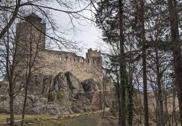
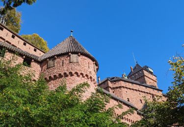
Le départ et l'arrivée ce font à Scherwiller au centre du village, parking à la Mairie et au niveau de l'Eglise. A un moment, vous n'êtes qu'à 400 m du Châteaux de l'Ortenbourg donc un petit crochet s'impose pour ceux qui aiment voir les Châteaux. Vous passerez aussi au Bernstein ( 2x )et oui petite boucle autour de celui-ci. Sinon la première fois maitrisez votre vitesse sur les petits sentiers descendants. Il y a aussi quelques passages techniques ... A Bientôt ! La Grenouille.

Elevation profile

Points of interest

Point of interest Scherwiller - Départ - Arrivée. - Photo
tracegps
SCHERWILLER 
Point of interest Scherwiller - Départ. - Photo
tracegps
SCHERWILLER 
Point of interest Scherwiller - S1 - Photo
tracegps
SCHERWILLER 
Point of interest Dambach-la-Ville - S10. - Photo
tracegps
DAMBACH-LA-VILLE 
Point of interest Dambach-la-Ville - S11. - Photo
tracegps
DAMBACH-LA-VILLE 
Point of interest Dambach-la-Ville - S12. - Photo
tracegps
DAMBACH-LA-VILLE 
Point of interest Dambach-la-Ville - S13. - Photo
tracegps
DAMBACH-LA-VILLE 
Point of interest Dambach-la-Ville - S14. - Photo
tracegps
DAMBACH-LA-VILLE 
Point of interest Dambach-la-Ville - S15. - Photo
tracegps
DAMBACH-LA-VILLE 
Point of interest Dambach-la-Ville - S16. - Photo
tracegps
DAMBACH-LA-VILLE 
Point of interest Dambach-la-Ville - S17. - Photo
tracegps
DAMBACH-LA-VILLE 
Point of interest Dambach-la-Ville - S18. - Photo
tracegps
DAMBACH-LA-VILLE 
Point of interest Dambach-la-Ville - S19. - Photo
tracegps
DAMBACH-LA-VILLE 
Point of interest Scherwiller - S2. - Photo
tracegps
SCHERWILLER 
Point of interest Dambach-la-Ville - S21. - Photo
tracegps
DAMBACH-LA-VILLE 
Point of interest Dambach-la-Ville - S22. - Photo
tracegps
DAMBACH-LA-VILLE 
Point of interest Dambach-la-Ville - S23. - Photo
tracegps
DAMBACH-LA-VILLE 
Point of interest Dambach-la-Ville - S24. - Photo
tracegps
DAMBACH-LA-VILLE 
Point of interest Dambach-la-Ville - S25. - Photo
tracegps
DAMBACH-LA-VILLE 
Point of interest Dambach-la-Ville - S26. - Photo
tracegps
DAMBACH-LA-VILLE 
Point of interest Dambach-la-Ville - S27. - Photo
tracegps
DAMBACH-LA-VILLE 
Point of interest Dambach-la-Ville - S28. - Photo
tracegps
DAMBACH-LA-VILLE 
Point of interest Dieffenthal - S29. - Photo
tracegps
DIEFFENTHAL 
Point of interest Scherwiller - S3. - Photo
tracegps
SCHERWILLER 
Point of interest Scherwiller - S30. - Photo
tracegps
SCHERWILLER 
Point of interest Scherwiller - S31. - Photo
tracegps
SCHERWILLER 
Point of interest Scherwiller - S32. - Photo
tracegps
SCHERWILLER 
Point of interest Scherwiller - S33. - Photo
tracegps
SCHERWILLER 
Point of interest Scherwiller - S34. - Photo
tracegps
SCHERWILLER 
Point of interest Scherwiller - S36. - Photo
tracegps
SCHERWILLER 
Point of interest Scherwiller - S37. - Photo
tracegps
SCHERWILLER 
Point of interest Scherwiller - S4. - Photo
tracegps
SCHERWILLER 
Point of interest Scherwiller - S5. - Photo
tracegps
SCHERWILLER 
Point of interest Scherwiller - S6. - Photo
tracegps
SCHERWILLER 
Point of interest Scherwiller - S7. - Photo
tracegps
SCHERWILLER 
Point of interest Dambach-la-Ville - S8. - Photo
tracegps
DAMBACH-LA-VILLE 
Point of interest Dambach-la-Ville - S9. - Photo
tracegps
DAMBACH-LA-VILLE 

Positioning

Country:
France
Region :
Grand Est
Department/Province :
Bas-Rhin
Municipality :
Scherwiller
Location:
Unknown
Start:(UTM)
382549 ; 5349336 (32U) N.

Comments

Please log in to post a review or rate the element


belle ballade à remettre au programme


Trails nearby

Trail Walking Dambach-la-Ville - Les ruines de Bernstein et d'Ortenbourg par la forêt - Photo
Walking
VacheKiri67

Walking

Medium
(1)
Dambach-la-Ville, Grand Est, Bas-Rhin, France
13 km | 18.5 km-effort
4h 38min
Yes
Trail Walking Châtenois - Le Hahnenberg et les balcons Sélestat - Photo
Walking
VacheKiri67

Walking

Medium
(2)
Châtenois, Grand Est, Bas-Rhin, France
12 km | 17.2 km-effort
4h 29min
Yes
Trail Walking Sélestat - Sentier de l'Illwald - Photo
Walking
tracegps

Walking

Medium
(1)
Sélestat, Grand Est, Bas-Rhin, France
13.2 km | 14.6 km-effort
3h 45min
Yes
Trail Walking Châtenois - Le Haut Koenigsbourg de Val de Ville - Photo
Walking
tracegps

Walking

Difficult
(1)
Châtenois, Grand Est, Bas-Rhin, France
16.8 km | 25 km-effort
5h 0min
Yes
Trail Mountain bike Thanvillé - Circuit de la Gadouille - Photo
Mountain bike
tracegps

Mountain bike

Difficult
(3)
Thanvillé, Grand Est, Bas-Rhin, France
18.4 km | 27 km-effort
1h 40min
Yes
Trail Walking Dambach-la-Ville - suuntoapp-Hiking-2023-12-26T08-42-47Z - Photo
Walking
GUIDE
holtzv

Walking

Very difficult
Dambach-la-Ville, Grand Est, Bas-Rhin, France
14.3 km | 21 km-effort
4h 43min
Yes
Trail Walking Kintzheim - suuntoapp-Hiking-2023-10-15T07-53-44Z - Photo
Walking
GUIDE
holtzv

Walking

Medium
Kintzheim, Grand Est, Bas-Rhin, France
18.5 km | 28 km-effort
6h 16min
Yes
Trail Walking Scherwiller - chateau  de ortenbourg - Photo
Walking
dudu42

Walking

Very easy
(1)
Scherwiller, Grand Est, Bas-Rhin, France
4.6 km | 7.9 km-effort
1h 29min
Yes
Trail Walking Sélestat - Sélestat : balade dans le Ried - Photo
Walking
Bart2015

Walking

Difficult
Sélestat, Grand Est, Bas-Rhin, France
11.4 km | 12.6 km-effort
2h 51min
Yes


Close
My subscriptions