Trail Cycle Doucier - Vallée et cascades du Hérisson -  Doucier - Photo

Vallée et cascades du Hérisson - Doucier

 tracegps
tracegps

User

© OpenStreetMap contributors
Length
Length
17 km
Max alt
Max alt
537 m
Uphill gradient
Uphill gradient
244 m
Km-Effort
Km-Effort  
20 km
Min alt
Min alt
501 m
Downhill gradient
Downhill gradient
243 m
Boucle
Boucle
Yes
Creation date :
2014-12-10 00:00:00.0
Updated on :
2014-12-10 00:00:00.0

(0 Reviews)

Cycle
Cycle
1h07
Difficulty : Easy

Scan this QR Code to open this trail in the SityTrail application

FREE GPS app for hiking

Logo SityTrail SityTrail

IGN / Geographical institutes

Download SityTrail from the App Store Download SityTrail from Google Play

Logo SityTrail SityTrail World

The world is yours!

Download SityTrail from the App Store Download SityTrail from Google Play Download SityTrail on Huawei AppGallery

About

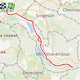
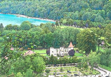
Trail Cycle of 17 km to be discovered at Bourgogne-Franche-Comté, Jura, Doucier. This trail is proposed by tracegps.

Description

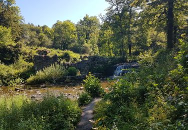
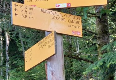
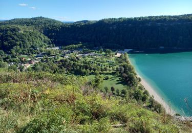
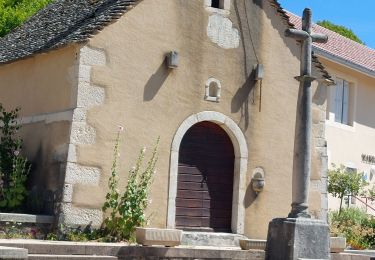
Circuit proposé par l'Office de Tourisme des lacs et petite montagne. Départ de Doucier. Route qui mène au départ de la randonnée des cascades du Hérisson en longeant 2 magnifiques lacs de pêche. N’oubliez pas votre antivol pour poser le vélo et faire une partie voire toute la randonnée des cascades. Attention cette route est très fréquentée en juillet et août. Un carnet de 16 fiches cyclo, en vente 5 € à l’Office de Tourisme, propose des circuits cyclo autour des lacs et en Petite Montagne de 15 à 100 km sur des petites routes tranquilles sans trop de dénivelé pour découvrir les curiosités de la région.

Elevation profile

Photos

Positioning

Country:
France
Region :
Bourgogne-Franche-Comté
Department/Province :
Jura
Municipality :
Doucier
Location:
Unknown
Start:(Dec)
Start:(UTM)
712609 ; 5170526 (31T) N.

Trails nearby

Trail Walking Menétrux-en-Joux - Les cascades du Hérisson : Boucle du randonneur - Photo
Walking
VacheKiri67

Walking

Medium
(3)
Menétrux-en-Joux, Bourgogne-Franche-Comté, Jura, France
14.5 km | 20 km-effort
5h 10min
Yes
Trail Walking Menétrux-en-Joux - Le Hérisson et ses cascades - Photo
Walking
tracegps

Walking

Medium
(7)
Menétrux-en-Joux, Bourgogne-Franche-Comté, Jura, France
11.9 km | 17.6 km-effort
4h 0min
Yes
Trail Mountain bike Doucier -  La Dame Blanche - Doucier - Photo
Mountain bike
tracegps

Mountain bike

Difficult
(1)
Doucier, Bourgogne-Franche-Comté, Jura, France
33 km | 42 km-effort
2h 30min
Yes
Trail Walking Hauteroche - Mirebel avec Taïga - Photo
Walking
GUIDE
David25400

Walking

Easy
Hauteroche, Bourgogne-Franche-Comté, Jura, France
6.6 km | 8.3 km-effort
2h 1min
Yes
Trail Walking Menétrux-en-Joux - Ménétrux-en-Joux - cascades Evantail et Hérisson - Saut de la Forge - La Fromagerie - Photo
Walking
Bart2015

Walking

Very difficult
Menétrux-en-Joux, Bourgogne-Franche-Comté, Jura, France
13.6 km | 19.7 km-effort
4h 28min
Yes
Trail Walking Doucier - Balisage Lac de Chambly - Photo
Walking
drarep

Walking

Difficult
(1)
Doucier, Bourgogne-Franche-Comté, Jura, France
11.4 km | 14.6 km-effort
3h 19min
Yes
Trail Walking Fontenu - Tour du lac de Chalain  - Photo
Walking
grasgilbert

Walking

Medium
Fontenu, Bourgogne-Franche-Comté, Jura, France
12.7 km | 16.3 km-effort
3h 56min
Yes
Trail Walking Menétrux-en-Joux - CASCADES DU HERISSON DEPUIS MENETRUX-EN-JOUX - Photo
Walking
walrou63

Walking

Very difficult
Menétrux-en-Joux, Bourgogne-Franche-Comté, Jura, France
15 km | 21 km-effort
4h 0min
Yes
Trail On foot Marigny - La Queille - Photo
On foot
PRO

On foot

Easy
Marigny, Bourgogne-Franche-Comté, Jura, France
6.7 km | 8.6 km-effort
1h 57min
No


Close
My subscriptions