Trail Walking Ubaye-Serre-Ponçon - Les Sources de la PIsse - Photo
© OpenStreetMap contributors
Length
Length
5 km
Max alt
Max alt
1860 m
Uphill gradient
Uphill gradient
431 m
Km-Effort
Km-Effort  
10.8 km
Min alt
Min alt
1418 m
Downhill gradient
Downhill gradient
431 m
Boucle
Boucle
Yes
Creation date :
2014-12-10 00:00:00.0
Updated on :
2014-12-10 00:00:00.0

(1 Reviews)

Walking
Walking
3h20
Difficulty : Difficult

Scan this QR Code to open this trail in the SityTrail application

FREE GPS app for hiking

Logo SityTrail SityTrail

IGN / Geographical institutes

Download SityTrail from the App Store Download SityTrail from Google Play

Logo SityTrail SityTrail World

The world is yours!

Download SityTrail from the App Store Download SityTrail from Google Play Download SityTrail on Huawei AppGallery

About

Trail Walking of 5 km to be discovered at Provence-Alpes-Côte d'Azur, Alpes-de-Haute-Provence, Ubaye-Serre-Ponçon. This trail is proposed by saintherant.

Description

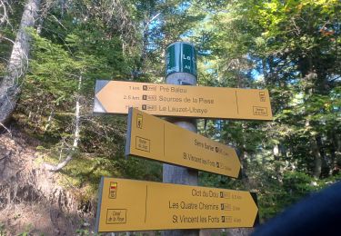
Variante du Canal de la Pisse ou du Rocher du Joug (départ Canal ou Pre Balou)Cette variante  permettra de monter jusqu’aux sources de la Pisse à 1850 mètres d’altitude, vous pourrez admirer les différentes résurgences qui alimentent le torrent qui descend par une série de très belles petites cascades avant le grand saut dans le vallon de Château Rolland
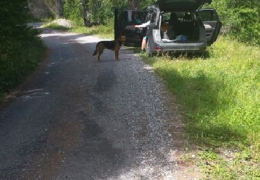
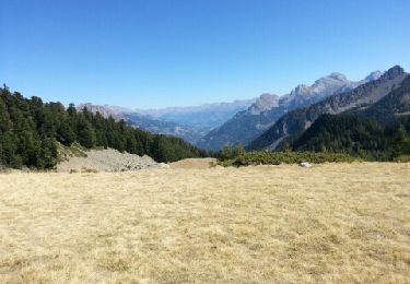
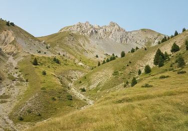
Au point Canal (1430 m), prendre la direction Pré Balou – Sources de la Pisse par une montée assez raide dans les sapins. Après une centaine de mètres, celle-ci débouche sur un large chemin, prendre à gauche. Après à peu près 400 mètres le chemin se transforme en un simple sentier, qu’il conviendra de suivre (bien suivre le balisage jaune et rouge) jusqu’au sommet au point Sources de la Pisse (1850 m). Arrivé à ce point, les plus courageux pourront continuer la montée sur 2 à 300 mètres en rive gauche du torrent et en contournant les cascades pour sortir dans le grand vallon abritant les résurgences d’eau.
La descente se fera par le même chemin, jusqu’au Clot du Dou.

Elevation profile

Positioning

Country:
France
Region :
Provence-Alpes-Côte d'Azur
Department/Province :
Alpes-de-Haute-Provence
Municipality :
Ubaye-Serre-Ponçon
Location:
Saint-Vincent-les-Forts
Start:(UTM)
293140 ; 4923149 (32T) N.

Comments

Please log in to post a review or rate the element


Trails nearby

Trail Walking Ubaye-Serre-Ponçon - MONTCLAR , les Rollands  , canal de la Pisse , Pre Balou , fontaine du loup , fontaine de l mane o l m s - Photo
Walking
RobinMicheline

Walking

Medium
(1)
Ubaye-Serre-Ponçon, Provence-Alpes-Côte d'Azur, Alpes-de-Haute-Provence, France
15.6 km | 23 km-effort
4h 22min
Yes
Trail Walking Le Lauzet-Ubaye - lac noir (col du bas) - Photo
Walking
gildascb

Walking

Easy
(1)
Le Lauzet-Ubaye, Provence-Alpes-Côte d'Azur, Alpes-de-Haute-Provence, France
11.9 km | 22 km-effort
4h 29min
Yes
Trail Walking Le Lauzet-Ubaye - lac du milieu - Photo
Walking
GebleuxGaetan

Walking

Easy
(2)
Le Lauzet-Ubaye, Provence-Alpes-Côte d'Azur, Alpes-de-Haute-Provence, France
8.2 km | 15.6 km-effort
2h 53min
Yes
Trail Walking Le Lauzet-Ubaye - Trou du Duc  - Photo
Walking
GUIDE
David25400

Walking

Medium
Le Lauzet-Ubaye, Provence-Alpes-Côte d'Azur, Alpes-de-Haute-Provence, France
14 km | 29 km-effort
6h 44min
Yes
Trail Walking Le Lauzet-Ubaye - Trou du Duc - Photo
Walking
GUIDE
David25400

Walking

Medium
Le Lauzet-Ubaye, Provence-Alpes-Côte d'Azur, Alpes-de-Haute-Provence, France
14 km | 29 km-effort
7h 19min
Yes
Trail Walking Montclar - SAINT JEAN MONTCLAR Le tour des chapelles par les chemins d autrefois  o   - Photo
Walking
RobinMicheline

Walking

Medium
(1)
Montclar, Provence-Alpes-Côte d'Azur, Alpes-de-Haute-Provence, France
14.5 km | 22 km-effort
4h 57min
Yes
Trail Walking Ubaye-Serre-Ponçon - Du Lac au Village - Photo
Walking
saintherant

Walking

Medium
(1)
Ubaye-Serre-Ponçon, Provence-Alpes-Côte d'Azur, Alpes-de-Haute-Provence, France
8.8 km | 15.1 km-effort
3h 40min
Yes
Trail Walking Le Lauzet-Ubaye - La Roche - Roche Rousse Taïga - Photo
Walking
GUIDE
David25400

Walking

Very easy
Le Lauzet-Ubaye, Provence-Alpes-Côte d'Azur, Alpes-de-Haute-Provence, France
5.6 km | 9.4 km-effort
1h 43min
Yes
Trail Walking Ubaye-Serre-Ponçon - S VINCENT LES FORTS . CANAL DE LA PISSE . FONTAINE DE LANE . FONTAINE DU LOIUP . O L S. NZ . - Photo
Walking
RobinMicheline

Walking

Medium
Ubaye-Serre-Ponçon, Provence-Alpes-Côte d'Azur, Alpes-de-Haute-Provence, France
8.5 km | 13.9 km-effort
2h 46min
Yes


Close
My subscriptions