Trail Walking Gerde - Casque du Lhéris - Gerde - Photo

Casque du Lhéris - Gerde

 tracegps
tracegps

User

© OpenStreetMap contributors
Length
Length
14.1 km
Max alt
Max alt
1577 m
Uphill gradient
Uphill gradient
736 m
Km-Effort
Km-Effort  
24 km
Min alt
Min alt
910 m
Downhill gradient
Downhill gradient
735 m
Boucle
Boucle
Yes
Creation date :
2014-12-10 00:00:00.0
Updated on :
2014-12-10 00:00:00.0

(0 Reviews)

Walking
Walking
5h00
Difficulty : Medium

Scan this QR Code to open this trail in the SityTrail application

FREE GPS app for hiking

Logo SityTrail SityTrail

IGN / Geographical institutes

Download SityTrail from the App Store Download SityTrail from Google Play

Logo SityTrail SityTrail World

The world is yours!

Download SityTrail from the App Store Download SityTrail from Google Play Download SityTrail on Huawei AppGallery

About

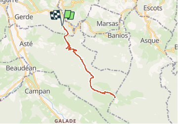
Trail Walking of 14.1 km to be discovered at Occitania, Hautespyrenees, Gerde. This trail is proposed by tracegps.

Description

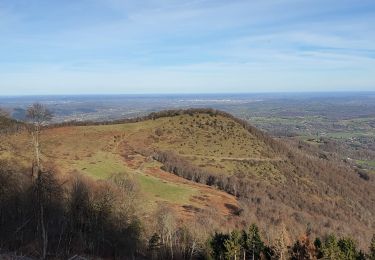
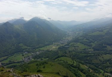
Départ d'un parking à la côte 910 au dessus du col des Palomières. Cheminement sur des sentiers de sous-bois jusqu'au pied du Casque. Au sommet de belles vues sur la chaîne. Randonnée un peu longue mais sans difficulté majeure mise à part la montée au Casque un peu raide.

Elevation profile

Photos

Positioning

Country:
France
Region :
Occitania
Department/Province :
Hautespyrenees
Municipality :
Gerde
Location:
Unknown
Start:(UTM)
271550 ; 4770212 (31T) N.

Trails nearby

Trail Walking Asque - Asque G3 2023 soum det Raygade - Photo
Walking
LouisROGER

Walking

Difficult
(1)
Asque, Occitania, Hautespyrenees, France
9.8 km | 16.7 km-effort
3h 47min
Yes
Trail Walking Beaudéan - LESPONNE entre torrents et cascades (G3) fait le 17 Juillet 2020
Walking
GUIDE
marmotte65

Walking

Very easy
Beaudéan, Occitania, Hautespyrenees, France
8.8 km | 12.9 km-effort
4h 30min
Yes
Trail Walking Bagnères-de-Bigorre - FEU 2015 - Etape 5 - Photo
Walking
Blavis

Walking

Easy
(1)
Bagnères-de-Bigorre, Occitania, Hautespyrenees, France
18.2 km | 30 km-effort
6h 29min
No
Trail Walking Castillon - FEU 2015 - Etape 4 - Photo
Walking
Blavis

Walking

Easy
(2)
Castillon, Occitania, Hautespyrenees, France
11.6 km | 18.1 km-effort
3h 43min
No
Trail Walking Gerde - Casque du Lheris - Photo
Walking
chrisgps

Walking

Medium
Gerde, Occitania, Hautespyrenees, France
16.8 km | 28 km-effort
6h 25min
Yes
Trail Road bike Beaudéan - hourquette - Photo
Road bike
BARAN

Road bike

Very difficult
(1)
Beaudéan, Occitania, Hautespyrenees, France
50 km | 65 km-effort
2h 54min
Yes
Trail Mountain bike Bagnères-de-Bigorre - Randonnée 1 mai haut de Bagneres  - Photo
Mountain bike
fred47

Mountain bike

Very difficult
Bagnères-de-Bigorre, Occitania, Hautespyrenees, France
28 km | 38 km-effort
3h 18min
Yes
Trail Walking Bagnères-de-Bigorre - tour du castelmouly - Photo
Walking
Martinet.Claude

Walking

Easy
(2)
Bagnères-de-Bigorre, Occitania, Hautespyrenees, France
12.7 km | 20 km-effort
4h 3min
Yes
Trail Walking Campan - Le Tour de la Bouche  - Campan - Photo
Walking
tracegps

Walking

Difficult
Campan, Occitania, Hautespyrenees, France
15.2 km | 28 km-effort
7h 0min
Yes


Close
My subscriptions