Trail Walking Saint-Hippolyte - Le tour de St Hippolyte - Photo

Le tour de St Hippolyte

 tracegps
tracegps

User

© OpenStreetMap contributors
Length
Length
1.5 km
Max alt
Max alt
265 m
Uphill gradient
Uphill gradient
28 m
Km-Effort
Km-Effort  
1.9 km
Min alt
Min alt
231 m
Downhill gradient
Downhill gradient
30 m
Boucle
Boucle
Yes
Creation date :
2014-12-10 00:00:00.0
Updated on :
2014-12-10 00:00:00.0

(0 Reviews)

Walking
Walking
45m
Difficulty : Easy

Scan this QR Code to open this trail in the SityTrail application

FREE GPS app for hiking

Logo SityTrail SityTrail

IGN / Geographical institutes

Download SityTrail from the App Store Download SityTrail from Google Play

Logo SityTrail SityTrail World

The world is yours!

Download SityTrail from the App Store Download SityTrail from Google Play Download SityTrail on Huawei AppGallery

About

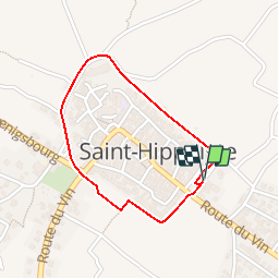
Trail Walking of 1.5 km to be discovered at Grand Est, Haut-Rhin, Saint-Hippolyte. This trail is proposed by tracegps.

Description

Une belle rando pour voir un beau petit village du Haut-Rhin et voir de bonne cave. Départ de l'allée des cygnes.

Elevation profile

Photos

Positioning

Country:
France
Region :
Grand Est
Department/Province :
Haut-Rhin
Municipality :
Saint-Hippolyte
Location:
Unknown
Start:(UTM)
379081 ; 5343361 (32U) N.

Trails nearby

Trail Walking Châtenois - Le Hahnenberg et les balcons Sélestat - Photo
Walking
VacheKiri67

Walking

Medium
(2)
Châtenois, Grand Est, Bas-Rhin, France
12 km | 17.2 km-effort
4h 29min
Yes
Trail Mountain bike Ribeauvillé - Ribeauvillé Riquewihr - Photo
Mountain bike
tracegps

Mountain bike

Medium
(1)
Ribeauvillé, Grand Est, Haut-Rhin, France
19.3 km | 24 km-effort
1h 30min
Yes
Trail Walking Kintzheim - suuntoapp-Hiking-2023-10-15T07-53-44Z - Photo
Walking
GUIDE
holtzv

Walking

Medium
Kintzheim, Grand Est, Bas-Rhin, France
18.5 km | 28 km-effort
6h 16min
Yes
Trail Walking Saint-Hippolyte - St hippolyte ht koenigsbourg - Photo
Walking
legereric

Walking

Medium
(2)
Saint-Hippolyte, Grand Est, Haut-Rhin, France
12 km | 18.7 km-effort
3h 27min
Yes
Trail Walking Bergheim - Berghien  - Photo
Walking
2433e59

Walking

Easy
Bergheim, Grand Est, Haut-Rhin, France
12.1 km | 15.6 km-effort
3h 37min
Yes
Trail Walking Saint-Hippolyte - St-Hippolyte - Rorschwihr - Grasberg - Bergheim - Reichenberg - Rodern - Photo
Walking
VacheKiri67

Walking

Medium
Saint-Hippolyte, Grand Est, Haut-Rhin, France
17.3 km | 22 km-effort
4h 28min
Yes
Trail Mountain bike Bergheim - 1 ère sortie - Photo
Mountain bike
Jeje Seuil

Mountain bike

Easy
Bergheim, Grand Est, Haut-Rhin, France
12.6 km | 19.1 km-effort
1h 53min
Yes
Trail Walking Rorschwihr - rorschwihr ac3 - Photo
Walking
colsonandre

Walking

Medium
Rorschwihr, Grand Est, Haut-Rhin, France
6.8 km | 9.2 km-effort
3h 54min
Yes
Trail Walking Thannenkirch - Taennchel par Thannenkirch - Photo
Walking
Mich&Agnès

Walking

Medium
(2)
Thannenkirch, Grand Est, Haut-Rhin, France
15.5 km | 23 km-effort
5h 19min
Yes


Close
My subscriptions