Trail Walking Chorges - Le Fein- crète du Ruban- CHORGES - Photo

Le Fein- crète du Ruban- CHORGES

 BLANCHET
BLANCHET

User

© OpenStreetMap contributors
Length
Length
15 km
Max alt
Max alt
1551 m
Uphill gradient
Uphill gradient
767 m
Km-Effort
Km-Effort  
25 km
Min alt
Min alt
921 m
Downhill gradient
Downhill gradient
620 m
Boucle
Boucle
No
Creation date :
2015-06-30 00:00:00.0
Updated on :
2015-06-30 00:00:00.0

(0 Reviews)

Walking
Walking
4h23
Difficulty : Medium

Scan this QR Code to open this trail in the SityTrail application

FREE GPS app for hiking

Logo SityTrail SityTrail

IGN / Geographical institutes

Download SityTrail from the App Store Download SityTrail from Google Play

Logo SityTrail SityTrail World

The world is yours!

Download SityTrail from the App Store Download SityTrail from Google Play Download SityTrail on Huawei AppGallery

About

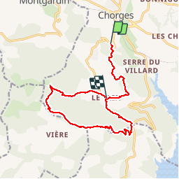
Trail Walking of 15 km to be discovered at Provence-Alpes-Côte d'Azur, Hautes-Alpes, Chorges. This trail is proposed by BLANCHET.

Description

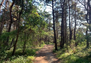
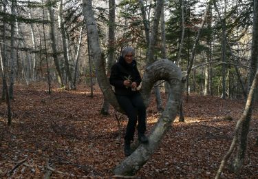
Belle rando menée tambour battant; Soleil dans les sous bois le matin, orage de grêle à la descente l''aprés-midi.
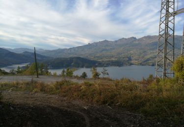
Superbe panorama sur Serre-Ponçon et l''Ubaye.

Elevation profile

Photos

Points of interest

Point of interest Chorges - Point 17 - Photo
BLANCHET
CHORGES 

Positioning

Country:
France
Region :
Provence-Alpes-Côte d'Azur
Department/Province :
Hautes-Alpes
Municipality :
Chorges
Location:
Unknown
Start:(UTM)
283318 ; 4934915 (32T) N.

Trails nearby

Trail Walking Chorges - Chanteloube et lac de Serre Ponçon - Photo
Walking
gildascb

Walking

Very easy
(2)
Chorges, Provence-Alpes-Côte d'Azur, Hautes-Alpes, France
5.9 km | 8.2 km-effort
1h 47min
Yes
Trail Walking Chorges - clôt c l'avais sur fein - Photo
Walking
Didier.kiehl

Walking

Very easy
(2)
Chorges, Provence-Alpes-Côte d'Azur, Hautes-Alpes, France
8 km | 12.6 km-effort
2h 24min
Yes
Trail Walking Chorges - Les Parias et la Pousterle par le col de Chorges - Photo
Walking
GUIDE
David25400

Walking

Medium
Chorges, Provence-Alpes-Côte d'Azur, Hautes-Alpes, France
15.4 km | 32 km-effort
6h 18min
Yes
Trail Walking Chorges - Montagne du Ruban - Photo
Walking
BLANCHET

Walking

Easy
(2)
Chorges, Provence-Alpes-Côte d'Azur, Hautes-Alpes, France
11 km | 17.4 km-effort
3h 39min
No
Trail Walking Chorges - CHORGES camping clé des champs Cantheloube retour par le nord - Photo
Walking
jll7513

Walking

Easy
Chorges, Provence-Alpes-Côte d'Azur, Hautes-Alpes, France
8.7 km | 12.1 km-effort
2h 44min
Yes
Trail Walking Le Sauze-du-Lac - balcons du lac 171121 - Photo
Walking
GUIDE
David25400

Walking

Very easy
Le Sauze-du-Lac, Provence-Alpes-Côte d'Azur, Hautes-Alpes, France
5.5 km | 8 km-effort
1h 29min
No
Trail Walking Le Sauze-du-Lac - La Chauchière  Grange Cézilly 181021 - Photo
Walking
GUIDE
David25400

Walking

Very easy
Le Sauze-du-Lac, Provence-Alpes-Côte d'Azur, Hautes-Alpes, France
4.7 km | 7.2 km-effort
2h 30min
Yes
Trail Walking Le Sauze-du-Lac - Crestioulin Champoutet Serre Gardette 031021 - Photo
Walking
GUIDE
David25400

Walking

Very easy
Le Sauze-du-Lac, Provence-Alpes-Côte d'Azur, Hautes-Alpes, France
6.2 km | 9.6 km-effort
3h 35min
Yes
Trail Walking Le Sauze-du-Lac - balcons du lac 270921 - Photo
Walking
GUIDE
David25400

Walking

Very easy
Le Sauze-du-Lac, Provence-Alpes-Côte d'Azur, Hautes-Alpes, France
3.3 km | 5 km-effort
1h 57min
Yes


Close
My subscriptions