Trail Walking Champs-Romain - Champs-Romain Tacot 12km - Photo

Champs-Romain Tacot 12km

 YV24
YV24

User

© OpenStreetMap contributors
Length
Length
11.6 km
Max alt
Max alt
304 m
Uphill gradient
Uphill gradient
205 m
Km-Effort
Km-Effort  
14.3 km
Min alt
Min alt
169 m
Downhill gradient
Downhill gradient
205 m
Boucle
Boucle
Yes
Creation date :
2019-02-11 18:21:49.886
Updated on :
2020-02-22 16:01:30.734

(0 Reviews)

Walking
Walking
3h06
Difficulty : Difficult

Scan this QR Code to open this trail in the SityTrail application

FREE GPS app for hiking

Logo SityTrail SityTrail

IGN / Geographical institutes

Download SityTrail from the App Store Download SityTrail from Google Play

Logo SityTrail SityTrail World

The world is yours!

Download SityTrail from the App Store Download SityTrail from Google Play Download SityTrail on Huawei AppGallery

About

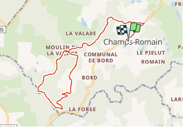
Trail Walking of 11.6 km to be discovered at New Aquitaine, Dordogne, Champs-Romain. This trail is proposed by YV24.

Description

Selon carte PDIPR St Pardoux-la-rivière.
Voir le saut du Chalard sur la Dronne

Elevation profile

Positioning

Country:
France
Region :
New Aquitaine
Department/Province :
Dordogne
Municipality :
Champs-Romain
Location:
Unknown
Start:(UTM)
326229 ; 5044514 (31T) N.

Trails nearby

Trail Walking Saint-Pardoux-la-Rivière - St-Pardoux-la-Rivière Dorie 13km - Photo
Walking
YV24

Walking

Easy
(1)
Saint-Pardoux-la-Rivière, New Aquitaine, Dordogne, France
12.4 km | 15.8 km-effort
3h 26min
Yes
Trail Walking Saint-Saud-Lacoussière - Boucle de la Dronne - Saint Saud - Photo
Walking
tracegps

Walking

Medium
(1)
Saint-Saud-Lacoussière, New Aquitaine, Dordogne, France
13.7 km | 17.2 km-effort
2h 30min
Yes
Trail Walking Augignac - les chaufauds - Photo
Walking
temmichel

Walking

Medium
Augignac, New Aquitaine, Dordogne, France
8.7 km | 10.4 km-effort
2h 14min
Yes
Trail Walking Champs-Romain - saut du chalard par Larret - Photo
Walking
Zygomat

Walking

Difficult
Champs-Romain, New Aquitaine, Dordogne, France
9.9 km | 13.5 km-effort
2h 56min
Yes
Trail Hybrid bike Saint-Pardoux-la-Rivière - Balade à vélo voie verte st pardaux la rivière - Photo
Hybrid bike
jumbo0861

Hybrid bike

Very easy
Saint-Pardoux-la-Rivière, New Aquitaine, Dordogne, France
34 km | 40 km-effort
3h 3min
No
Trail Walking Champs-Romain - Périgord vert saut du chalard - Photo
Walking
attelageplaisir

Walking

Very easy
Champs-Romain, New Aquitaine, Dordogne, France
3.8 km | 5.2 km-effort
1h 39min
Yes
Trail Walking Saint-Pardoux-la-Rivière - Boucle- st  pardoux - Photo
Walking
Melifera

Walking

Very difficult
Saint-Pardoux-la-Rivière, New Aquitaine, Dordogne, France
19.4 km | 25 km-effort
5h 34min
No
Trail sport Saint-Pardoux-la-Rivière - 2021-02-24_01h29m54_Boucle PNR 191 km Variante Avril 2019 - Photo
sport
vimpere

sport

Very easy
Saint-Pardoux-la-Rivière, New Aquitaine, Dordogne, France
195 km | 241 km-effort
Unknown
Yes
Trail Walking Saint-Saud-Lacoussière - Saint Saud Lacoussiere - Photo
Walking
Zygomat

Walking

Easy
Saint-Saud-Lacoussière, New Aquitaine, Dordogne, France
11.8 km | 15.2 km-effort
3h 16min
Yes


Close
My subscriptions