Trail Walking Vauvenargues - SAINTE VICTOIRE   VAUVENARGUES - Photo
© OpenStreetMap contributors
Length
Length
14.3 km
Max alt
Max alt
997 m
Uphill gradient
Uphill gradient
768 m
Km-Effort
Km-Effort  
24 km
Min alt
Min alt
353 m
Downhill gradient
Downhill gradient
760 m
Boucle
Boucle
Yes
Creation date :
2019-04-14 08:24:47.08
Updated on :
2019-04-27 18:53:15.305

(0 Reviews)

Walking
Walking
6h50
Difficulty : Difficult

Scan this QR Code to open this trail in the SityTrail application

FREE GPS app for hiking

Logo SityTrail SityTrail

IGN / Geographical institutes

Download SityTrail from the App Store Download SityTrail from Google Play

Logo SityTrail SityTrail World

The world is yours!

Download SityTrail from the App Store Download SityTrail from Google Play Download SityTrail on Huawei AppGallery

About

Trail Walking of 14.3 km to be discovered at Provence-Alpes-Côte d'Azur, Bouches-du-Rhône, Vauvenargues. This trail is proposed by FLORENSAC.

Description

Bonjour
Départ du parking  à l'entrée de Vauvenargues  
traverser le village et passer devant le parking à étages
prendre sur la gauche le balisage est vert jusqu'au sommet des crêtes
(sentier un peu ardu avec des marches assez abruptes)
continuer ensuite sur la droite pour arriver en suivant le GR jusqu'à la croix
le retour en descendant sur la gauche visiter le prieuré
magnifique endroit
continuer par la piste  jusqu'à l'arrivée au parking

Elevation profile

Photos

Positioning

Country:
France
Region :
Provence-Alpes-Côte d'Azur
Department/Province :
Bouches-du-Rhône
Municipality :
Vauvenargues
Location:
Unknown
Start:(UTM)
710522 ; 4825655 (31T) N.

Trails nearby

Trail Walking Saint-Antonin-sur-Bayon - Ste Victoire - Le Garagaï - Photo
Walking
ETMU5496

Walking

Difficult
(1)
Saint-Antonin-sur-Bayon, Provence-Alpes-Côte d'Azur, Bouches-du-Rhône, France
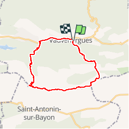
15.8 km | 28 km-effort
4h 36min
Yes
Trail Walking Vauvenargues - Le Signal, Montagne Sainte-Victoire - Photo
Walking
tracegps

Walking

Medium
(2)
Vauvenargues, Provence-Alpes-Côte d'Azur, Bouches-du-Rhône, France
15 km | 25 km-effort
6h 19min
Yes
Trail Walking Saint-Antonin-sur-Bayon - 2023-02-10 Sainte Victoire Bau des Vespres - Photo
Walking
GUIDE
Kargil

Walking

Difficult
Saint-Antonin-sur-Bayon, Provence-Alpes-Côte d'Azur, Bouches-du-Rhône, France
10 km | 18.8 km-effort
3h 30min
Yes
Trail On foot Vauvenargues - Sentier des Venturiers - Photo
On foot
PRO

On foot

Easy
Vauvenargues, Provence-Alpes-Côte d'Azur, Bouches-du-Rhône, France
5 km | 10.5 km-effort
2h 23min
No
Trail Walking Saint-Antonin-sur-Bayon - pas du clapier et tracé vert - Photo
Walking
GUIDE
amiral13

Walking

Difficult
Saint-Antonin-sur-Bayon, Provence-Alpes-Côte d'Azur, Bouches-du-Rhône, France
10.5 km | 21 km-effort
5h 24min
Yes
Trail Walking Saint-Antonin-sur-Bayon - Sainte Victoire - Bau Cézanne - tracé jaune - Photo
Walking
GUIDE
amiral13

Walking

Difficult
(1)
Saint-Antonin-sur-Bayon, Provence-Alpes-Côte d'Azur, Bouches-du-Rhône, France
5.3 km | 12.2 km-effort
2h 28min
Yes
Trail Walking Saint-Antonin-sur-Bayon - Sommet Croix de Provence - Barrage du Bimont - Photo
Walking
GUIDE
lhomme.ph

Walking

Medium
Saint-Antonin-sur-Bayon, Provence-Alpes-Côte d'Azur, Bouches-du-Rhône, France
14.2 km | 25 km-effort
5h 3min
Yes
Trail Walking Jouques - le Concors - Photo
Walking
GUIDE
amiral13

Walking

Easy
Jouques, Provence-Alpes-Côte d'Azur, Bouches-du-Rhône, France
8.5 km | 14.4 km-effort
3h 31min
Yes
Trail Walking Puyloubier - traversée St Ser, le pic des Mouches, Puyloubier - Photo
Walking
GUIDE
amiral13

Walking

Difficult
(1)
Puyloubier, Provence-Alpes-Côte d'Azur, Bouches-du-Rhône, France
8.4 km | 16.5 km-effort
5h 47min
No


Close
My subscriptions