Trail Walking Fillière - LE PARMELAN: ANGLETTAZ - GRANDE GLACIERE - GROTTE DE L'ENFER - LAPIAZ - REFUGE... RETOUR PAR GRAND & PETIT MONTOIR - Photo

LE PARMELAN: ANGLETTAZ - GRANDE GLACIERE - GROTTE DE L'ENFER - LAPIAZ - REFUGE... RETOUR PAR GRAND & PETIT MONTOIR

© OpenStreetMap contributors
Length
Length
9 km
Max alt
Max alt
1820 m
Uphill gradient
Uphill gradient
497 m
Km-Effort
Km-Effort  
15.6 km
Min alt
Min alt
1491 m
Downhill gradient
Downhill gradient
483 m
Boucle
Boucle
Yes
Creation date :
2019-05-25 15:41:43.439
Updated on :
2019-08-10 05:56:39.117

(2 Reviews)

Walking
Walking
4h30
Difficulty : Difficult

Scan this QR Code to open this trail in the SityTrail application

FREE GPS app for hiking

Logo SityTrail SityTrail

IGN / Geographical institutes

Download SityTrail from the App Store Download SityTrail from Google Play

Logo SityTrail SityTrail World

The world is yours!

Download SityTrail from the App Store Download SityTrail from Google Play Download SityTrail on Huawei AppGallery

About

Trail Walking of 9 km to be discovered at Auvergne-Rhône-Alpes, Upper Savoy, Fillière. This trail is proposed by djeepee74.
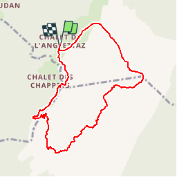
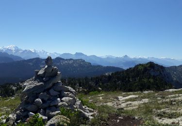
Description

BOUCLE
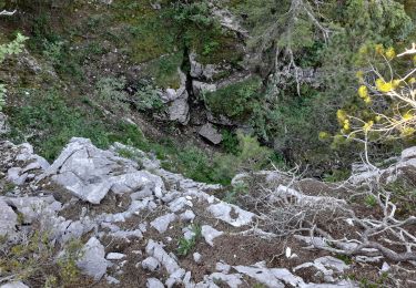
Il faut compter 03h00 pour rejoindre le refuge du Parmelan à partir d'Anglettaz... la marche sur lapiaz est plus lente que sur sentier !
Au retour, pour "agrémenter" le circuit, descendre le grand montoir... pour remonter ensuite par le petit montoir... afin de bien mériter un "grand Monaco" au chalet de l'Anglettaz.
Ce circuit doit se faire par temps dégagé... méfiance au brouillard dans les lapiaz... ET, bien entendu, ne pas s'aventurer dans le "grand montoir", surtout à la descente, par terrain glissant.

Elevation profile

Photos

Positioning

Country:
France
Region :
Auvergne-Rhône-Alpes
Department/Province :
Upper Savoy
Municipality :
Fillière
Location:
Aviernoz
Start:(UTM)
286431 ; 5093728 (32T) N.

Comments

Please log in to post a review or rate the element


ah... les lapiaz... comptez plutôt 04:30 pour la rando dans son intégralité


Trails nearby

Trail Walking Fillière - Les Molliets-Pertuis-Ablon 10 Mai 2018 - Photo
Walking
GUIDE
Kargil

Walking

Difficult
Fillière, Auvergne-Rhône-Alpes, Upper Savoy, France
18.2 km | 32 km-effort
7h 6min
Yes
Trail Walking Fillière - 20170806115426 90167 data - Photo
Walking
domcobe

Walking

Easy
(1)
Fillière, Auvergne-Rhône-Alpes, Upper Savoy, France
3.2 km | 8.6 km-effort
1h 53min
No
Trail Walking Fillière - tour parmelan - Photo
Walking
micfor

Walking

Easy
(2)
Fillière, Auvergne-Rhône-Alpes, Upper Savoy, France
12.9 km | 22 km-effort
4h 0min
Yes
Trail Walking Fillière - SOUS DINE PAR LE PAS DU ROC - Photo
Walking
djeepee74

Walking

Difficult
Fillière, Auvergne-Rhône-Alpes, Upper Savoy, France
18.2 km | 34 km-effort
7h 44min
Yes
Trail Walking Fillière - refuge Patmelan via anglettaz . gd glacière . fontaine du tour . grotte de l enfer  / retour via gd montoir et pt montoir  - Photo
Walking
stef789

Walking

Medium
Fillière, Auvergne-Rhône-Alpes, Upper Savoy, France
10.2 km | 16.1 km-effort
6h 1min
Yes
Trail Walking Fillière - LE PARMELAN: ANGLETTAZ - GRANDE GLACIERE -
Walking
djeepee74

Walking

Medium
Fillière, Auvergne-Rhône-Alpes, Upper Savoy, France
9.4 km | 14.5 km-effort
4h 35min
Yes
Trail On foot Dingy-Saint-Clair - PR Boucle du Parmelan - Photo
On foot
PRO

On foot

Medium
Dingy-Saint-Clair, Auvergne-Rhône-Alpes, Upper Savoy, France
11.3 km | 25 km-effort
5h 38min
No
Trail Walking Fillière - Tete du Parmelan - Photo
Walking
GuyVachet

Walking

Difficult
Fillière, Auvergne-Rhône-Alpes, Upper Savoy, France
14.9 km | 26 km-effort
7h 15min
Yes
Trail Walking Fillière - GLIERES: TRAVERSEE PAS DU ROC - MONUMENT DES GLIERES - Photo
Walking
djeepee74

Walking

Medium
Fillière, Auvergne-Rhône-Alpes, Upper Savoy, France
6.3 km | 14.1 km-effort
3h 0min
No


Close
My subscriptions