Trail Walking Thônes - Les Glières depuis le Crêt - Photo

Les Glières depuis le Crêt

 Chabard
Chabard

User

© OpenStreetMap contributors
Length
Length
24 km
Max alt
Max alt
1813 m
Uphill gradient
Uphill gradient
1260 m
Km-Effort
Km-Effort  
41 km
Min alt
Min alt
910 m
Downhill gradient
Downhill gradient
1255 m
Boucle
Boucle
Yes
Creation date :
2019-08-15 05:15:44.0
Updated on :
2019-08-17 16:30:50.341

(0 Reviews)

Walking
Walking
6h30
Difficulty : Unknown

Scan this QR Code to open this trail in the SityTrail application

FREE GPS app for hiking

Logo SityTrail SityTrail

IGN / Geographical institutes

Download SityTrail from the App Store Download SityTrail from Google Play

Logo SityTrail SityTrail World

The world is yours!

Download SityTrail from the App Store Download SityTrail from Google Play Download SityTrail on Huawei AppGallery

About

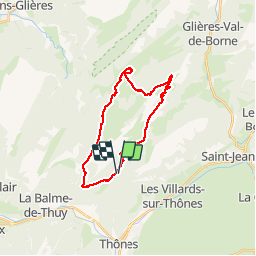
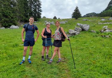
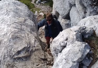
Trail Walking of 24 km to be discovered at Auvergne-Rhône-Alpes, Upper Savoy, Thônes. This trail is proposed by Chabard.

Description

La Tetaz, la Rosière, la maison du Plateau, le monument, la montagne des Auges, la Buffaz, le Crêt

Elevation profile

Photos

Positioning

Country:
France
Region :
Auvergne-Rhône-Alpes
Department/Province :
Upper Savoy
Municipality :
Thônes
Location:
Unknown
Start:(UTM)
292445 ; 5088213 (32T) N.

Trails nearby

Trail Walking Thônes - Mont Lachat - Le Belvédère  par grotte de Barmafi - Photo
Walking
GUIDE
Kargil

Walking

Medium
Thônes, Auvergne-Rhône-Alpes, Upper Savoy, France
9.5 km | 21 km-effort
3h 57min
Yes
Trail Walking Thônes - Tour Montagne des Auges par Tetaz et Buffaz - Photo
Walking
GUIDE
Kargil

Walking

Medium
Thônes, Auvergne-Rhône-Alpes, Upper Savoy, France
19.1 km | 33 km-effort
5h 45min
Yes
Trail Walking Fillière - Les Molliets-Pertuis-Ablon 10 Mai 2018 - Photo
Walking
GUIDE
Kargil

Walking

Difficult
Fillière, Auvergne-Rhône-Alpes, Upper Savoy, France
18.2 km | 32 km-effort
7h 6min
Yes
Trail Snowshoes Thônes - Mlande Platenet Frassot  Mlande - Photo
Snowshoes
thierryd

Snowshoes

Very easy
(1)
Thônes, Auvergne-Rhône-Alpes, Upper Savoy, France
7.3 km | 13.7 km-effort
3h 24min
Yes
Trail Walking Thônes - Col de l'ovine - Photo
Walking
Mariolebeno

Walking

Medium
(1)
Thônes, Auvergne-Rhône-Alpes, Upper Savoy, France
15.8 km | 29 km-effort
6h 0min
Yes
Trail Walking Thônes - Sarrasins (arche des) - Photo
Walking
Patricelecerf

Walking

Medium
(1)
Thônes, Auvergne-Rhône-Alpes, Upper Savoy, France
12.2 km | 23 km-effort
7h 5min
Yes
Trail Walking Thônes - Boucle des Glières à partir du Sapey de Thônes  - Photo
Walking
Chabard

Walking

Difficult
Thônes, Auvergne-Rhône-Alpes, Upper Savoy, France
20 km | 36 km-effort
6h 23min
Yes
Trail Walking Fillière - GLIERES: PACCOT - COL DE L'OVINE - POINTE DE LA QUEBLETTE - Photo
Walking
djeepee74

Walking

Medium
Fillière, Auvergne-Rhône-Alpes, Upper Savoy, France
10.3 km | 17.2 km-effort
3h 45min
Yes
Trail Walking Fillière - tête de l'Apertaz, tête ronde et tête noire - Photo
Walking
nadd73

Walking

Medium
Fillière, Auvergne-Rhône-Alpes, Upper Savoy, France
12.6 km | 21 km-effort
5h 55min
Yes


Close
My subscriptions