Trail Walking Bélesta - Caladroy  - Photo
 ThonyM
ThonyM

User

© OpenStreetMap contributors
Length
Length
15.9 km
Max alt
Max alt
514 m
Uphill gradient
Uphill gradient
433 m
Km-Effort
Km-Effort  
22 km
Min alt
Min alt
226 m
Downhill gradient
Downhill gradient
431 m
Boucle
Boucle
Yes
Creation date :
2020-02-19 07:42:56.0
Updated on :
2020-02-19 12:04:41.798

(0 Reviews)

Walking
Walking
4h20
Difficulty : Medium

Scan this QR Code to open this trail in the SityTrail application

FREE GPS app for hiking

Logo SityTrail SityTrail

IGN / Geographical institutes

Download SityTrail from the App Store Download SityTrail from Google Play

Logo SityTrail SityTrail World

The world is yours!

Download SityTrail from the App Store Download SityTrail from Google Play Download SityTrail on Huawei AppGallery

About

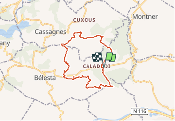
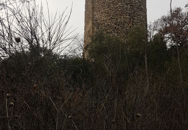
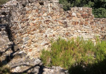
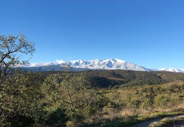
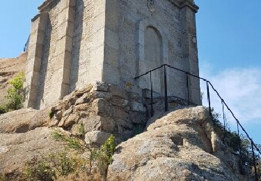
Trail Walking of 15.9 km to be discovered at Occitania, Pyrénées-Orientales, Bélesta. This trail is proposed by ThonyM.

Description

Un parcours facile et ludique. Peut-être à éviter en plein été

Elevation profile

Photos

Positioning

Country:
France
Region :
Occitania
Department/Province :
Pyrénées-Orientales
Municipality :
Bélesta
Location:
Unknown
Start:(UTM)
471269 ; 4729960 (31T) N.

Trails nearby

Trail Walking Bélesta - Boucle du Pic Aubeill - Photo
Walking
bfrogneux

Walking

Easy
(1)
Bélesta, Occitania, Pyrénées-Orientales, France
8 km | 10.9 km-effort
2h 24min
Yes
Trail Walking Cassagnes - pic d'abeille - Photo
Walking
randovivi

Walking

Very easy
(2)
Cassagnes, Occitania, Pyrénées-Orientales, France
8.1 km | 10.8 km-effort
3h 0min
Yes
Trail Walking Millas - millas n'efface millas fait le 27 02 2023 - Photo
Walking
66Gribouille83

Walking

Medium
Millas, Occitania, Pyrénées-Orientales, France
8.3 km | 9 km-effort
2h 33min
Yes
Trail Walking Cassagnes - F66 Cassagnes pic Aubeill - Photo
Walking
ageo

Walking

Easy
Cassagnes, Occitania, Pyrénées-Orientales, France
6.3 km | 8.4 km-effort
2h 20min
No
Trail Walking Ille-sur-Têt - Ille belesta ille  - Photo
Walking
Erius

Walking

Medium
Ille-sur-Têt, Occitania, Pyrénées-Orientales, France
16.1 km | 22 km-effort
4h 17min
Yes
Trail Walking Bélesta - 20200907 tour depuis Bélesta - Photo
Walking
ThonyM

Walking

Easy
Bélesta, Occitania, Pyrénées-Orientales, France
15.5 km | 21 km-effort
4h 3min
Yes
Trail Walking Bélesta - Belesta  - Photo
Walking
ThonyM

Walking

Medium
Bélesta, Occitania, Pyrénées-Orientales, France
48 km | 0 m-effort
6h 42min
No
Trail Other activity Ille-sur-Têt - ille sur tet orgues église casenove et truffiere - Photo
Other activity
Erius

Other activity

Very easy
Ille-sur-Têt, Occitania, Pyrénées-Orientales, France
16.2 km | 20 km-effort
4h 36min
No
Trail Walking Ille-sur-Têt - Ille sur tet - Photo
Walking
Fildesir

Walking

Very easy
Ille-sur-Têt, Occitania, Pyrénées-Orientales, France
16.4 km | 22 km-effort
6h 31min
No


Close
My subscriptions