Trail On foot Castellane - Rando sans boucle de 11km avec 221 + et 500 - arrivée SENEZ - Photo

Rando sans boucle de 11km avec 221 + et 500 - arrivée SENEZ

© OpenStreetMap contributors
Length
Length
10.7 km
Max alt
Max alt
1167 m
Uphill gradient
Uphill gradient
221 m
Km-Effort
Km-Effort  
14.6 km
Min alt
Min alt
778 m
Downhill gradient
Downhill gradient
497 m
Boucle
Boucle
No
Creation date :
2020-10-20 08:51:22.976
Updated on :
2020-10-20 08:56:38.318

(0 Reviews)

On foot
On foot
5h00
Difficulty : Medium

Scan this QR Code to open this trail in the SityTrail application

FREE GPS app for hiking

Logo SityTrail SityTrail

IGN / Geographical institutes

Download SityTrail from the App Store Download SityTrail from Google Play

Logo SityTrail SityTrail World

The world is yours!

Download SityTrail from the App Store Download SityTrail from Google Play Download SityTrail on Huawei AppGallery

About

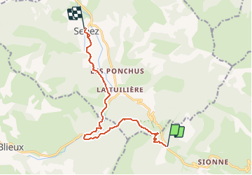
Trail On foot of 10.7 km to be discovered at Provence-Alpes-Côte d'Azur, Alpes-de-Haute-Provence, Castellane. This trail is proposed by eaea7charles.

Description

Le départ se fait peu après TAULANNE, vers SENEZ, sur la route Napoléon. Elle emprunte les sentiers suivis par l'empereur, vers SENEZ. Lieu d'arrivée l'hotel AZIMUT , à la sortie de Senez.

Elevation profile

Positioning

Country:
France
Region :
Provence-Alpes-Côte d'Azur
Department/Province :
Alpes-de-Haute-Provence
Municipality :
Castellane
Location:
Unknown
Start:(UTM)
294833 ; 4860872 (32T) N.

Trails nearby

Trail Walking Castellane - Sentier des Siréniens  - Photo
Walking
Dervalmarc

Walking

Very easy
(1)
Castellane, Provence-Alpes-Côte d'Azur, Alpes-de-Haute-Provence, France
3.8 km | 5.5 km-effort
1h 9min
Yes
Trail Walking Senez - La Voie Impériale (Etape 2 : Senez - Chaudon-Norante (La Clappe)) - Photo
Walking
tracegps

Walking

Difficult
(1)
Senez, Provence-Alpes-Côte d'Azur, Alpes-de-Haute-Provence, France
19.5 km | 30 km-effort
6h 0min
No
Trail Walking Castellane - cadiere de brandis - Photo
Walking
choux83

Walking

Very easy
(1)
Castellane, Provence-Alpes-Côte d'Azur, Alpes-de-Haute-Provence, France
8.9 km | 14.6 km-effort
2h 27min
No
Trail Walking Castellane - La Baume-Ruines du Vieux Courchons - Photo
Walking
Salomi

Walking

Difficult
(1)
Castellane, Provence-Alpes-Côte d'Azur, Alpes-de-Haute-Provence, France
12.2 km | 18.5 km-effort
4h 11min
Yes
Trail Mountain bike Castellane - vtt-de-castellane-au-lac-de-castillon - Photo
Mountain bike
GUIDE
pascalou73

Mountain bike

Very easy
Castellane, Provence-Alpes-Côte d'Azur, Alpes-de-Haute-Provence, France
14.7 km | 19.5 km-effort
Unknown
Yes
Trail Walking Castellane - Cadières de Brandis - Photo
Walking
jmheydorff

Walking

Medium
(1)
Castellane, Provence-Alpes-Côte d'Azur, Alpes-de-Haute-Provence, France
10.7 km | 18.4 km-effort
3h 51min
Yes
Trail Walking Castellane - La Colle : Cadières de Brandis - Photo
Walking
ETMU5496

Walking

Difficult
Castellane, Provence-Alpes-Côte d'Azur, Alpes-de-Haute-Provence, France
17.5 km | 30 km-effort
6h 54min
Yes
Trail Walking Castellane - Col des lèques - Cadières de branlis - Photo
Walking
RayFab

Walking

Difficult
Castellane, Provence-Alpes-Côte d'Azur, Alpes-de-Haute-Provence, France
7.8 km | 13.4 km-effort
3h 2min
Yes
Trail Walking Castellane - Chasteuil (04) ; Cadières de Brandis - Photo
Walking
ETMU5496

Walking

Difficult
Castellane, Provence-Alpes-Côte d'Azur, Alpes-de-Haute-Provence, France
18.3 km | 33 km-effort
5h 13min
Yes


Close
My subscriptions