Trail Walking Lus-la-Croix-Haute - Le Rognon - Photo
 GAPIAN43
GAPIAN43

User

© OpenStreetMap contributors
Length
Length
12.3 km
Max alt
Max alt
1830 m
Uphill gradient
Uphill gradient
761 m
Km-Effort
Km-Effort  
22 km
Min alt
Min alt
1231 m
Downhill gradient
Downhill gradient
761 m
Boucle
Boucle
Yes
Creation date :
2014-12-10 00:00:00.0
Updated on :
2014-12-10 00:00:00.0

(1 Reviews)

Walking
Walking
4h33
Difficulty : Medium

Scan this QR Code to open this trail in the SityTrail application

FREE GPS app for hiking

Logo SityTrail SityTrail

IGN / Geographical institutes

Download SityTrail from the App Store Download SityTrail from Google Play

Logo SityTrail SityTrail World

The world is yours!

Download SityTrail from the App Store Download SityTrail from Google Play Download SityTrail on Huawei AppGallery

About

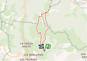
Trail Walking of 12.3 km to be discovered at Auvergne-Rhône-Alpes, Drôme, Lus-la-Croix-Haute. This trail is proposed by GAPIAN43.

Description

Ballade dans le Triève Le Rognon depuis les Siezes

Elevation profile

Positioning

Country:
France
Region :
Auvergne-Rhône-Alpes
Department/Province :
Drôme
Municipality :
Lus-la-Croix-Haute
Location:
Unknown
Start:(UTM)
714597 ; 4952511 (31T) N.

Comments

Please log in to post a review or rate the element


Trails nearby

Trail Walking Lus-la-Croix-Haute - R48 - Gorges des Amayères - Photo
Walking
GUIDE+

Walking

Easy
Lus-la-Croix-Haute, Auvergne-Rhône-Alpes, Drôme, France
10.3 km | 17.5 km-effort
3h 1min
No
Trail Walking Lus-la-Croix-Haute - R38   Col des Aiguilles depuis Lus - Photo
Walking
GUIDE+

Walking

Medium
Lus-la-Croix-Haute, Auvergne-Rhône-Alpes, Drôme, France
5.6 km | 15 km-effort
2h 53min
Yes
Trail Walking Glandage - Le Jocou 2 - Photo
Walking
Marco05

Walking

Difficult
Glandage, Auvergne-Rhône-Alpes, Drôme, France
8.5 km | 18.1 km-effort
4h 0min
Yes
Trail Walking Lus-la-Croix-Haute - Pointe Feuillette - Photo
Walking
Marco05

Walking

Difficult
Lus-la-Croix-Haute, Auvergne-Rhône-Alpes, Drôme, France
10.5 km | 20 km-effort
4h 36min
Yes
Trail Walking Lus-la-Croix-Haute - Pointe feuillette  - Photo
Walking
ajd26

Walking

Medium
Lus-la-Croix-Haute, Auvergne-Rhône-Alpes, Drôme, France
11.4 km | 21 km-effort
4h 52min
Yes
Trail Walking Lus-la-Croix-Haute - MAS REBUFAT - POINTE FEUILLETTE  - Photo
Walking
RD78-38

Walking

Medium
Lus-la-Croix-Haute, Auvergne-Rhône-Alpes, Drôme, France
11.7 km | 20 km-effort
3h 33min
Yes
Trail Walking Tréminis - Le col de La Croix - Photo
Walking
dominiq

Walking

Difficult
Tréminis, Auvergne-Rhône-Alpes, Isère, France
8.8 km | 16.5 km-effort
3h 31min
Yes
Trail Walking Lus-la-Croix-Haute - Antécime de La Toussière - Photo
Walking
GuyVachet

Walking

Difficult
Lus-la-Croix-Haute, Auvergne-Rhône-Alpes, Drôme, France
8.6 km | 17.4 km-effort
5h 44min
Yes
Trail Walking Lalley - Serre Motaire et Lazare - Photo
Walking
PapouBertrand

Walking

Very difficult
Lalley, Auvergne-Rhône-Alpes, Isère, France
14.6 km | 24 km-effort
23h 45min
Yes


Close
My subscriptions