Trail Horseback riding Gunsbach - Randonnée Equestre Chateaux du Pflixbourg et Hohlandsbourg - Photo

Randonnée Equestre Chateaux du Pflixbourg et Hohlandsbourg

© OpenStreetMap contributors
Length
Length
24 km
Max alt
Max alt
629 m
Uphill gradient
Uphill gradient
583 m
Km-Effort
Km-Effort  
32 km
Min alt
Min alt
272 m
Downhill gradient
Downhill gradient
579 m
Boucle
Boucle
Yes
Creation date :
2021-06-29 19:33:30.557
Updated on :
2021-06-29 19:52:40.186

(0 Reviews)

Horseback riding
Horseback riding
4h08
Difficulty : Difficult

Scan this QR Code to open this trail in the SityTrail application

FREE GPS app for hiking

Logo SityTrail SityTrail

IGN / Geographical institutes

Download SityTrail from the App Store Download SityTrail from Google Play

Logo SityTrail SityTrail World

The world is yours!

Download SityTrail from the App Store Download SityTrail from Google Play Download SityTrail on Huawei AppGallery

About

Trail Horseback riding of 24 km to be discovered at Grand Est, Haut-Rhin, Gunsbach. This trail is proposed by Gaelle Hugg.

Description

Randonnée à la journée au départ de Gunsbach, possibilité de garée à la maison du Fromage (sur demande).
Passage par le château de Pflixbourg et le château du Hohlandsbourg.

Elevation profile

Photos

Points of interest

Point of interest Wintzenheim - Maison Forestière - Photo
Gaelle Hugg
WINTZENHEIM 
Point of interest Wintzenheim - Chateau du Pflixbourg - Photo
Gaelle Hugg
Point of interest Wintzenheim - Roche du Corbeau - Photo
Gaelle Hugg
WINTZENHEIM 
Point of interest Wintzenheim - Chateau du Hohlandsbourg - Photo
Gaelle Hugg
Point of interest Wintzenheim - Fontaine de la Dame - Photo
Gaelle Hugg
WINTZENHEIM 

Positioning

Country:
France
Region :
Grand Est
Department/Province :
Haut-Rhin
Municipality :
Gunsbach
Location:
Unknown
Start:(UTM)
363497 ; 5323247 (32U) N.

Trails nearby

Trail Walking Munster - De Munster aux 3 Fours (Aller) - Munster - Photo
Walking
tracegps

Walking

Difficult
(1)
Munster, Grand Est, Haut-Rhin, France
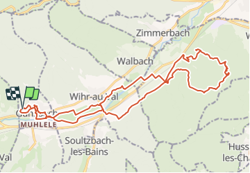
14.8 km | 27 km-effort
5h 0min
No
Trail Walking Hohrod - Circuit historique 1914-18 Hohrodberg - Linge - Photo
Walking
VacheKiri67

Walking

Medium
(1)
Hohrod, Grand Est, Haut-Rhin, France
14 km | 19.8 km-effort
5h 50min
Yes
Trail Walking Munster - 19.06.13.Munster  - Photo
Walking
ROPPJP

Walking

Very easy
(1)
Munster, Grand Est, Haut-Rhin, France
7.3 km | 10.6 km-effort
2h 10min
Yes
Trail Horseback riding Gunsbach - Le petit Hohnack - verkort (23) - Photo
Horseback riding
eddyvermeulen1

Horseback riding

Easy
(1)
Gunsbach, Grand Est, Haut-Rhin, France
13.1 km | 18.4 km-effort
2h 25min
Yes
Trail Walking Soultzeren - 2022-12-27 Marche Soultzeren Lac Forlet Hautes Huttes Glasborn - Photo
Walking
GUIDE
holtzv

Walking

Very difficult
Soultzeren, Grand Est, Haut-Rhin, France
21 km | 34 km-effort
5h 47min
Yes
Trail Walking Hohrod - Hohrodberg - Le Linge - Photo
Walking
sit68000

Walking

Easy
(2)
Hohrod, Grand Est, Haut-Rhin, France
6.5 km | 10.3 km-effort
2h 2min
Yes
Trail Walking Munster - Munster Narrenstein - Photo
Walking
serge.rougerie

Walking

Medium
(1)
Munster, Grand Est, Haut-Rhin, France
4.7 km | 7.7 km-effort
1h 24min
No
Trail Walking Orbey - Les Pierres tremblantes - Photo
Walking
VacheKiri67

Walking

Medium
Orbey, Grand Est, Haut-Rhin, France
11.7 km | 17.4 km-effort
3h 57min
Yes
Trail Walking Orbey - Circuit des 2 lacs : lac du Forlet et lac Vert - Photo
Walking
VacheKiri67

Walking

Medium
Orbey, Grand Est, Haut-Rhin, France
14.2 km | 20 km-effort
4h 48min
Yes


Close
My subscriptions