Trail Walking Bagnères-de-Luchon - 2022 08 -Transpyrénéen 2 : Bagnères de Luchon -Fos - Photo

2022 08 -Transpyrénéen 2 : Bagnères de Luchon -Fos

 LEGUE
LEGUE

User

© OpenStreetMap contributors
Length
Length
30 km
Max alt
Max alt
2190 m
Uphill gradient
Uphill gradient
1846 m
Km-Effort
Km-Effort  
55 km
Min alt
Min alt
535 m
Downhill gradient
Downhill gradient
1920 m
Boucle
Boucle
No
Creation date :
2022-08-02 04:32:39.0
Updated on :
2022-08-02 21:16:15.926

(0 Reviews)

Walking
Walking
7h08
Difficulty : Very difficult

Scan this QR Code to open this trail in the SityTrail application

FREE GPS app for hiking

Logo SityTrail SityTrail

IGN / Geographical institutes

Download SityTrail from the App Store Download SityTrail from Google Play

Logo SityTrail SityTrail World

The world is yours!

Download SityTrail from the App Store Download SityTrail from Google Play Download SityTrail on Huawei AppGallery

About

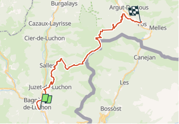
Trail Walking of 30 km to be discovered at Occitania, Haute-Garonne, Bagnères-de-Luchon. This trail is proposed by LEGUE.

Description

2000m de positif
2000m de négatif
Parti à 7h15 arrivé épuisé à 19h
28km

Elevation profile

Photos

Positioning

Country:
France
Region :
Occitania
Department/Province :
Haute-Garonne
Municipality :
Bagnères-de-Luchon
Location:
Unknown
Start:(UTM)
303330 ; 4739715 (31T) N.

Trails nearby

Trail Snowshoes Juzet-de-Luchon - JUZET - PAS DE LA COMBE (LABACH) - Photo
Snowshoes
Marcocroco

Snowshoes

Medium
(1)
Juzet-de-Luchon, Occitania, Haute-Garonne, France
7.1 km | 12.5 km-effort
2h 33min
Yes
Trail Walking Saint-Mamet - Fonds de Burbe - Saint Mamet - Photo
Walking
tracegps

Walking

Difficult
(1)
Saint-Mamet, Occitania, Haute-Garonne, France
15.6 km | 27 km-effort
4h 0min
Yes
Trail Mountain bike Saint-Aventin - Luchon Kbour - Photo
Mountain bike
tracegps

Mountain bike

Very difficult
(1)
Saint-Aventin, Occitania, Haute-Garonne, France
11 km | 16.7 km-effort
1h 0min
No
Trail Walking Saccourvielle - Cap de Salières en boucle depuis Saccourvielle - Photo
Walking
GUIDE
lhomme.ph

Walking

Medium
Saccourvielle, Occitania, Haute-Garonne, France
12.1 km | 24 km-effort
6h 23min
Yes
Trail Walking Bagnères-de-Luchon - GR 10 - 3 - Photo
Walking
loic09

Walking

Medium
(2)
Bagnères-de-Luchon, Occitania, Haute-Garonne, France
250 km | 489 km-effort
89h 8min
No
Trail Walking Saint-Aventin - Cabane de Courreau en boucle depuis St Aventin  - Photo
Walking
GUIDE
lhomme.ph

Walking

Medium
Saint-Aventin, Occitania, Haute-Garonne, France
13.3 km | 24 km-effort
6h 10min
Yes
Trail Walking Artigue - Artigue par la cabane du plan Bosc et la cabane de Saunères - Photo
Walking
swp648

Walking

Difficult
Artigue, Occitania, Haute-Garonne, France
10.5 km | 18.3 km-effort
4h 10min
Yes
Trail On foot Saint-Aventin - La Forestière - Photo
On foot
PRO

On foot

Easy
Saint-Aventin, Occitania, Haute-Garonne, France
7.3 km | 11.7 km-effort
2h 39min
No
Trail On foot Castillon-de-Larboust - Le cirque des Crabioules - Photo
On foot
PRO

On foot

Easy
Castillon-de-Larboust, Occitania, Haute-Garonne, France
8.2 km | 15.2 km-effort
3h 26min
No


Close
My subscriptions