Trail Walking Ille-sur-Têt - Ille sur Têt -Rodès -Ropidère - Photo

Ille sur Têt -Rodès -Ropidère

© OpenStreetMap contributors
Length
Length
23 km
Max alt
Max alt
467 m
Uphill gradient
Uphill gradient
759 m
Km-Effort
Km-Effort  
33 km
Min alt
Min alt
143 m
Downhill gradient
Downhill gradient
757 m
Boucle
Boucle
Yes
Creation date :
2019-05-27 16:40:53.551
Updated on :
2019-05-27 16:40:53.759

(0 Reviews)

Walking
Walking
6h53
Difficulty : Medium

Scan this QR Code to open this trail in the SityTrail application

FREE GPS app for hiking

Logo SityTrail SityTrail

IGN / Geographical institutes

Download SityTrail from the App Store Download SityTrail from Google Play

Logo SityTrail SityTrail World

The world is yours!

Download SityTrail from the App Store Download SityTrail from Google Play Download SityTrail on Huawei AppGallery

About

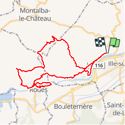
Trail Walking of 23 km to be discovered at Occitania, Pyrénées-Orientales, Ille-sur-Têt. This trail is proposed by MarieFrancoise.

Description

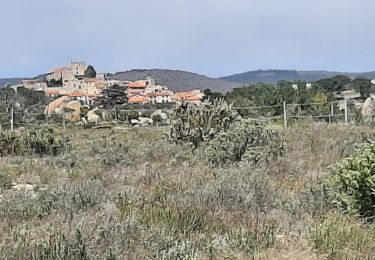
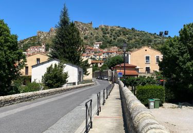
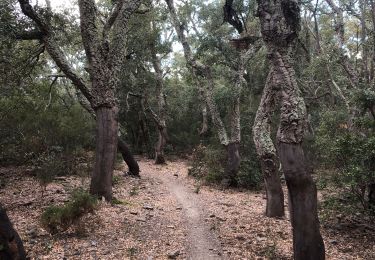
jolie rando. se garer au bord de la Têt
peut aussi s arrêter au château de Rodès

Elevation profile

Photos

Positioning

Country:
France
Region :
Occitania
Department/Province :
Pyrénées-Orientales
Municipality :
Ille-sur-Têt
Location:
Unknown
Start:(UTM)
468156 ; 4724914 (31T) N.

Trails nearby

Trail Walking Ille-sur-Têt - ILLE TÊT 66 - PIC PEDROUS - CASESNOVES - Photo
Walking
jeff66

Walking

Medium
(10)
Ille-sur-Têt, Occitania, Pyrénées-Orientales, France
11 km | 15.3 km-effort
2h 22min
Yes
Trail Walking Bélesta - Boucle du Pic Aubeill - Photo
Walking
bfrogneux

Walking

Easy
(1)
Bélesta, Occitania, Pyrénées-Orientales, France
8 km | 10.9 km-effort
2h 24min
Yes
Trail Walking Montalba-le-Château - Montauban le château corral grandes or - Photo
Walking
66Gribouille83

Walking

Difficult
Montalba-le-Château, Occitania, Pyrénées-Orientales, France
12.9 km | 16.3 km-effort
3h 42min
Yes
Trail Walking Montalba-le-Château - montant a - Photo
Walking
66Gribouille83

Walking

Difficult
Montalba-le-Château, Occitania, Pyrénées-Orientales, France
11.8 km | 14.7 km-effort
5h 2min
No
Trail Walking Rodès - 20221222  Rodés - Domanova…. Boucle  - Photo
Walking
ThonyM

Walking

Medium
Rodès, Occitania, Pyrénées-Orientales, France
21 km | 33 km-effort
5h 49min
Yes
Trail Walking Ille-sur-Têt - Ille st jules - Photo
Walking
66Gribouille83

Walking

Difficult
Ille-sur-Têt, Occitania, Pyrénées-Orientales, France
11.2 km | 12.7 km-effort
3h 2min
Yes
Trail Walking Rodès - Gorges de la Guillera - Photo
Walking
Dadou 1

Walking

Easy
Rodès, Occitania, Pyrénées-Orientales, France
3.2 km | 4.9 km-effort
1h 37min
Yes
Trail Walking Rodès - 20220217 au départ de Rodes - Photo
Walking
ThonyM

Walking

Medium
Rodès, Occitania, Pyrénées-Orientales, France
15.2 km | 26 km-effort
4h 56min
Yes
Trail Walking Bouleternère - Bouleternere - Photo
Walking
ombrabella

Walking

Medium
Bouleternère, Occitania, Pyrénées-Orientales, France
13.9 km | 20 km-effort
3h 52min
Yes


Close
My subscriptions