Trail Walking Villac - 2023-03-10_15h30m09_Cirkwi-Boucle_du_village_rouge - Photo

2023-03-10_15h30m09_Cirkwi-Boucle_du_village_rouge

 swp648
swp648

User

© OpenStreetMap contributors
Length
Length
8.1 km
Max alt
Max alt
308 m
Uphill gradient
Uphill gradient
305 m
Km-Effort
Km-Effort  
12.1 km
Min alt
Min alt
141 m
Downhill gradient
Downhill gradient
305 m
Boucle
Boucle
Yes
Creation date :
2023-03-10 14:30:09.808
Updated on :
2023-03-10 14:37:20.219

(1 Reviews)

Walking
Walking
2h45
Difficulty : Difficult

Scan this QR Code to open this trail in the SityTrail application

FREE GPS app for hiking

Logo SityTrail SityTrail

IGN / Geographical institutes

Download SityTrail from the App Store Download SityTrail from Google Play

Logo SityTrail SityTrail World

The world is yours!

Download SityTrail from the App Store Download SityTrail from Google Play Download SityTrail on Huawei AppGallery

About

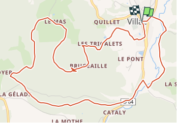
Trail Walking of 8.1 km to be discovered at New Aquitaine, Dordogne, Villac. This trail is proposed by swp648.

Description

Dans le bourg aux maisons en grès rouge, vous pourrez visiter l'église du XIIe siècle de style roman, découvrir les nombreux cours d'eau et sources, puits, lavoirs et fontaine. Le viaduc de l'Elle est désormais incontournable dans la découverte de la commune.

Elevation profile

Positioning

Country:
France
Region :
New Aquitaine
Department/Province :
Dordogne
Municipality :
Villac
Location:
Unknown
Start:(UTM)
362856 ; 5005132 (31T) N.

Comments

Please log in to post a review or rate the element


Trails nearby

Trail Walking Louignac - Louignac-Les sarcophages - Photo
Walking
houbart

Walking

Easy
(2)
Louignac, New Aquitaine, Corrèze, France
5.3 km | 6.9 km-effort
1h 36min
Yes
Trail Walking Peyrignac - boucle de la nuelle  - Photo
Walking
dmortier

Walking

Medium
Peyrignac, New Aquitaine, Dordogne, France
6.9 km | 9.3 km-effort
2h 14min
Yes
Trail Walking Beauregard-de-Terrasson - track - Photo
Walking
swp648

Walking

Difficult
Beauregard-de-Terrasson, New Aquitaine, Dordogne, France
11.4 km | 15.7 km-effort
3h 34min
Yes
Trail Walking Villac - 2023-03-10_16h12m44_UTF-8''%56%69%6C%6C%61%63%20%43%C3%B4%74%65%20%64%65%20%6C%61%20%47%65%6C%6C%61%64%65%2E%67%70%78 - Photo
Walking
swp648

Walking

Difficult
(1)
Villac, New Aquitaine, Dordogne, France
11 km | 16.9 km-effort
3h 50min
Yes
Trail Walking Villac - 2023-03-10_15h54m09_gpx-trace villac - Photo
Walking
swp648

Walking

Difficult
Villac, New Aquitaine, Dordogne, France
10 km | 12.6 km-effort
2h 51min
Yes
Trail Walking Châtres - boucle chatres - Photo
Walking
fab0202

Walking

Easy
(1)
Châtres, New Aquitaine, Dordogne, France
10.9 km | 14.7 km-effort
2h 42min
Yes
Trail Walking Cublac - Les mines long - Photo
Walking
fanthou

Walking

Medium
Cublac, New Aquitaine, Corrèze, France
8.3 km | 11.1 km-effort
2h 52min
Yes
Trail Walking Cublac - Les mines long - Photo
Walking
caro94

Walking

Medium
(3)
Cublac, New Aquitaine, Corrèze, France
8.3 km | 11.1 km-effort
2h 52min
Yes
Trail Walking Louignac - Les sarcophages - Photo
Walking
houbart

Walking

Easy
Louignac, New Aquitaine, Corrèze, France
6 km | 7.9 km-effort
1h 42min
Yes


Close
My subscriptions