Trail Walking Villac - 2023-03-10_15h54m09_gpx-trace villac - Photo

2023-03-10_15h54m09_gpx-trace villac

 swp648
swp648

User

© OpenStreetMap contributors
Length
Length
10 km
Max alt
Max alt
240 m
Uphill gradient
Uphill gradient
197 m
Km-Effort
Km-Effort  
12.6 km
Min alt
Min alt
148 m
Downhill gradient
Downhill gradient
196 m
Boucle
Boucle
Yes
Creation date :
2023-03-10 14:54:10.048
Updated on :
2023-03-10 15:03:35.634

(0 Reviews)

Walking
Walking
2h51
Difficulty : Difficult

Scan this QR Code to open this trail in the SityTrail application

FREE GPS app for hiking

Logo SityTrail SityTrail

IGN / Geographical institutes

Download SityTrail from the App Store Download SityTrail from Google Play

Logo SityTrail SityTrail World

The world is yours!

Download SityTrail from the App Store Download SityTrail from Google Play Download SityTrail on Huawei AppGallery

About

Trail Walking of 10 km to be discovered at New Aquitaine, Dordogne, Villac. This trail is proposed by swp648.

Description

Source randogps
Petit village de caractère,
Parcours agréable et sans difficulté qui emprunte
l'ancienne voie de chemin de fer,
des chemins en sous-bois et un peu de route.

Bonne randonnée.

Elevation profile

Positioning

Country:
France
Region :
New Aquitaine
Department/Province :
Dordogne
Municipality :
Villac
Location:
Unknown
Start:(UTM)
362964 ; 5005105 (31T) N.

Trails nearby

Trail Walking Louignac - Louignac-Les sarcophages - Photo
Walking
houbart

Walking

Easy
(2)
Louignac, New Aquitaine, Corrèze, France
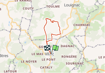
5.3 km | 6.9 km-effort
1h 36min
Yes
Trail Walking Beauregard-de-Terrasson - track - Photo
Walking
swp648

Walking

Difficult
Beauregard-de-Terrasson, New Aquitaine, Dordogne, France
11.4 km | 15.7 km-effort
3h 34min
Yes
Trail Walking Villac - 2023-03-10_16h12m44_UTF-8''%56%69%6C%6C%61%63%20%43%C3%B4%74%65%20%64%65%20%6C%61%20%47%65%6C%6C%61%64%65%2E%67%70%78 - Photo
Walking
swp648

Walking

Difficult
(1)
Villac, New Aquitaine, Dordogne, France
11 km | 16.9 km-effort
3h 50min
Yes
Trail Walking Villac - 2023-03-10_15h30m09_Cirkwi-Boucle_du_village_rouge - Photo
Walking
swp648

Walking

Difficult
(1)
Villac, New Aquitaine, Dordogne, France
8.1 km | 12.1 km-effort
2h 45min
Yes
Trail Walking Châtres - boucle chatres - Photo
Walking
fab0202

Walking

Easy
(1)
Châtres, New Aquitaine, Dordogne, France
10.9 km | 14.7 km-effort
2h 42min
Yes
Trail Walking Cublac - Les mines long - Photo
Walking
fanthou

Walking

Medium
Cublac, New Aquitaine, Corrèze, France
8.3 km | 11.1 km-effort
2h 52min
Yes
Trail Walking Cublac - Les mines long - Photo
Walking
caro94

Walking

Medium
(3)
Cublac, New Aquitaine, Corrèze, France
8.3 km | 11.1 km-effort
2h 52min
Yes
Trail Walking Louignac - Les sarcophages - Photo
Walking
houbart

Walking

Easy
Louignac, New Aquitaine, Corrèze, France
6 km | 7.9 km-effort
1h 42min
Yes
Trail Walking Châtres - Chatres (21-10-2017) Après-midi - Photo
Walking
godardenys

Walking

Easy
Châtres, New Aquitaine, Dordogne, France
14.5 km | 21 km-effort
4h 23min
Yes


Close
My subscriptions