Trail Walking Beauregard-de-Terrasson - track - Photo
 swp648
swp648

User

© OpenStreetMap contributors
Length
Length
11.4 km
Max alt
Max alt
316 m
Uphill gradient
Uphill gradient
320 m
Km-Effort
Km-Effort  
15.7 km
Min alt
Min alt
154 m
Downhill gradient
Downhill gradient
320 m
Boucle
Boucle
Yes
Creation date :
2024-03-08 09:47:57.6
Updated on :
2024-03-08 09:53:28.605

(0 Reviews)

Walking
Walking
3h34
Difficulty : Difficult

Scan this QR Code to open this trail in the SityTrail application

FREE GPS app for hiking

Logo SityTrail SityTrail

IGN / Geographical institutes

Download SityTrail from the App Store Download SityTrail from Google Play

Logo SityTrail SityTrail World

The world is yours!

Download SityTrail from the App Store Download SityTrail from Google Play Download SityTrail on Huawei AppGallery

About

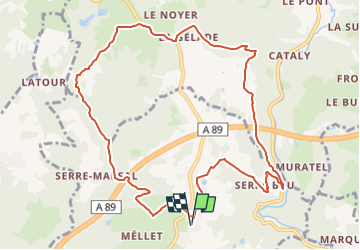
Trail Walking of 11.4 km to be discovered at New Aquitaine, Dordogne, Beauregard-de-Terrasson. This trail is proposed by swp648.

Description

Parking du terrain de sport de Beauregard-de-Terrasson (Dordogne 24)
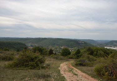
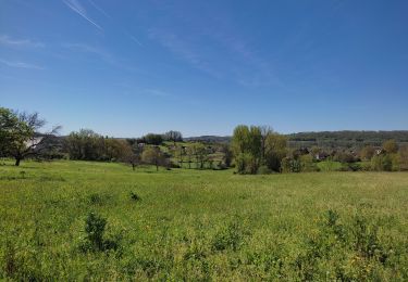
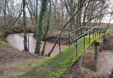
Circuit à faire en famille car sans difficulté au nord de Beauregard.
Le parcours est une succession de chemins, pistes et petites routes très peu fréquentées.
Source Randogps

Elevation profile

Positioning

Country:
France
Region :
New Aquitaine
Department/Province :
Dordogne
Municipality :
Beauregard-de-Terrasson
Location:
Unknown
Start:(UTM)
361088 ; 5001662 (31T) N.

Trails nearby

Trail On foot Condat-sur-Vézère - Boucle de la Commanderie - Photo
On foot
dmortier

On foot

Easy
Condat-sur-Vézère, New Aquitaine, Dordogne, France
9.5 km | 12.6 km-effort
2h 20min
Yes
Trail Walking Les Farges - vezere_6 - Photo
Walking
fanthou

Walking

Medium
(1)
Les Farges, New Aquitaine, Dordogne, France
8.7 km | 11.8 km-effort
2h 31min
Yes
Trail Walking Les Farges - vezere_5 - Photo
Walking
fanthou

Walking

Medium
(2)
Les Farges, New Aquitaine, Dordogne, France
7 km | 9.6 km-effort
2h 3min
Yes
Trail Walking Peyrignac - boucle de la nuelle  - Photo
Walking
dmortier

Walking

Medium
Peyrignac, New Aquitaine, Dordogne, France
6.9 km | 9.3 km-effort
2h 14min
Yes
Trail Walking Terrasson-Lavilledieu - sur les hauts de terrasson  - Photo
Walking
dmortier

Walking

Difficult
Terrasson-Lavilledieu, New Aquitaine, Dordogne, France
12.4 km | 16.1 km-effort
3h 11min
Yes
Trail Walking Les Farges - 2024-01-31 13:41 - Photo
Walking
Reider

Walking

Difficult
Les Farges, New Aquitaine, Dordogne, France
10.9 km | 15.1 km-effort
3h 26min
Yes
Trail Walking Villac - 2023-03-10_16h12m44_UTF-8''%56%69%6C%6C%61%63%20%43%C3%B4%74%65%20%64%65%20%6C%61%20%47%65%6C%6C%61%64%65%2E%67%70%78 - Photo
Walking
swp648

Walking

Difficult
(1)
Villac, New Aquitaine, Dordogne, France
11 km | 16.9 km-effort
3h 50min
Yes
Trail Walking Villac - 2023-03-10_15h54m09_gpx-trace villac - Photo
Walking
swp648

Walking

Difficult
Villac, New Aquitaine, Dordogne, France
10 km | 12.6 km-effort
2h 51min
Yes
Trail Walking Villac - 2023-03-10_15h30m09_Cirkwi-Boucle_du_village_rouge - Photo
Walking
swp648

Walking

Difficult
(1)
Villac, New Aquitaine, Dordogne, France
8.1 km | 12.1 km-effort
2h 45min
Yes


Close
My subscriptions