Trail Walking Chambéry - 170323 premiers pas après opération Bissy - Photo

170323 premiers pas après opération Bissy

© OpenStreetMap contributors
Length
Length
4 km
Max alt
Max alt
478 m
Uphill gradient
Uphill gradient
140 m
Km-Effort
Km-Effort  
5.8 km
Min alt
Min alt
341 m
Downhill gradient
Downhill gradient
139 m
Boucle
Boucle
Yes
Creation date :
2023-03-17 14:22:31.061
Updated on :
2023-03-18 22:43:03.472

(0 Reviews)

Walking
Walking
1h20
Difficulty : Very easy

Scan this QR Code to open this trail in the SityTrail application

FREE GPS app for hiking

Logo SityTrail SityTrail

IGN / Geographical institutes

Download SityTrail from the App Store Download SityTrail from Google Play

Logo SityTrail SityTrail World

The world is yours!

Download SityTrail from the App Store Download SityTrail from Google Play Download SityTrail on Huawei AppGallery

About

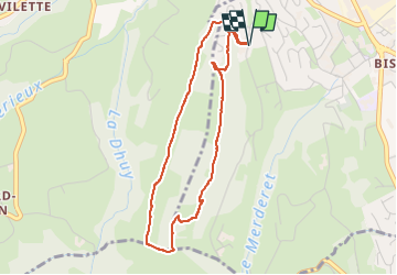
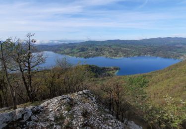
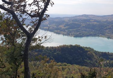
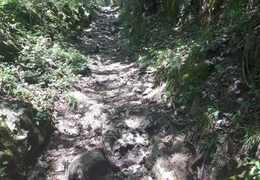
Trail Walking of 4 km to be discovered at Auvergne-Rhône-Alpes, Savoy, Chambéry. This trail is proposed by mzonzon05.

Description

petit viron post opératoire bien agréable sur le chemin de Coirat. C'est globalement plat et peut donc se faire en famille, avec des personnes âgées, en courant, en VTT pépère ... Les points de vue sur Belledonne, les Bauges et le lac sont sympas.

Elevation profile

Positioning

Country:
France
Region :
Auvergne-Rhône-Alpes
Department/Province :
Savoy
Municipality :
Chambéry
Location:
Unknown
Start:(UTM)
724468 ; 5051638 (31T) N.

Trails nearby

Trail Mountain bike Le Bourget-du-Lac - Chartreuse - Col du Crucifix - Photo
Mountain bike
tracegps

Mountain bike

Difficult
(2)
Le Bourget-du-Lac, Auvergne-Rhône-Alpes, Savoy, France
27 km | 40 km-effort
4h 0min
Yes
Trail Mountain bike Cognin - Autour du Corbeley - Photo
Mountain bike
baudrine

Mountain bike

Medium
(1)
Cognin, Auvergne-Rhône-Alpes, Savoy, France
25 km | 38 km-effort
2h 23min
Yes
Trail Walking Aiguebelette-le-Lac - Mont grêle  - Photo
Walking
grattounette

Walking

Difficult
(2)
Aiguebelette-le-Lac, Auvergne-Rhône-Alpes, Savoy, France
17.8 km | 32 km-effort
8h 5min
Yes
Trail Trail La Motte-Servolex - Château Richard et croix du Signal  - Photo
Trail
nadd73

Trail

Medium
La Motte-Servolex, Auvergne-Rhône-Alpes, Savoy, France
11.1 km | 20 km-effort
2h 1min
Yes
Trail Walking Aiguebelette-le-Lac - Mont Grêle  - Photo
Walking
Zasa

Walking

Medium
Aiguebelette-le-Lac, Auvergne-Rhône-Alpes, Savoy, France
16.3 km | 30 km-effort
5h 0min
Yes
Trail Walking Aiguebelette-le-Lac - Belvédère du Rocher du Corbeau - Photo
Walking
GuyVachet

Walking

Difficult
(1)
Aiguebelette-le-Lac, Auvergne-Rhône-Alpes, Savoy, France
5 km | 9.3 km-effort
2h 7min
Yes
Trail Walking Aiguebelette-le-Lac - aiguebelette, col du crucifix - Photo
Walking
francislassauce

Walking

Difficult
Aiguebelette-le-Lac, Auvergne-Rhône-Alpes, Savoy, France
9.8 km | 17.4 km-effort
4h 14min
Yes
Trail Walking Saint-Sulpice - Col du Crucifix par St Sulpice - Photo
Walking
brigittesontag

Walking

Medium
Saint-Sulpice, Auvergne-Rhône-Alpes, Savoy, France
5.5 km | 10.5 km-effort
2h 40min
Yes
Trail Walking Aiguebelette-le-Lac - l'épine d'Aiguelette - Photo
Walking
gwenola63

Walking

Difficult
Aiguebelette-le-Lac, Auvergne-Rhône-Alpes, Savoy, France
7.5 km | 12.9 km-effort
3h 38min
Yes


Close
My subscriptions