Trail Walking Saint-Franc - Boucle autour de saint Franc - Photo

Boucle autour de saint Franc

© OpenStreetMap contributors
Length
Length
6.1 km
Max alt
Max alt
686 m
Uphill gradient
Uphill gradient
138 m
Km-Effort
Km-Effort  
8 km
Min alt
Min alt
617 m
Downhill gradient
Downhill gradient
132 m
Boucle
Boucle
Yes
Creation date :
2023-10-29 13:23:54.0
Updated on :
2023-10-29 15:02:11.671

(0 Reviews)

Walking
Walking
1h37
Difficulty : Very easy

Scan this QR Code to open this trail in the SityTrail application

FREE GPS app for hiking

Logo SityTrail SityTrail

IGN / Geographical institutes

Download SityTrail from the App Store Download SityTrail from Google Play

Logo SityTrail SityTrail World

The world is yours!

Download SityTrail from the App Store Download SityTrail from Google Play Download SityTrail on Huawei AppGallery

About

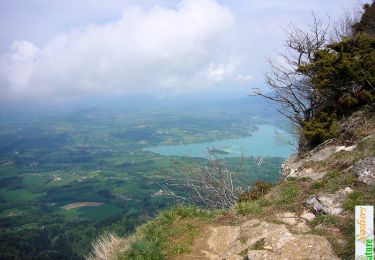
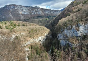
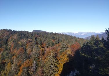
Trail Walking of 6.1 km to be discovered at Auvergne-Rhône-Alpes, Savoy, Saint-Franc. This trail is proposed by choubaka77.

Description

Boucle très sympathique avec de belles vues.
ATTENTION A LA CHASSE en automne 🍂

Elevation profile

Photos

Positioning

Country:
France
Region :
Auvergne-Rhône-Alpes
Department/Province :
Savoy
Municipality :
Saint-Franc
Location:
Unknown
Start:(UTM)
714550 ; 5040982 (31T) N.

Trails nearby

Trail Walking Attignat-Oncin - Le Mont Grelle 1425m, depuis Attignat - Oncin - Photo
Walking
tracegps

Walking

Medium
(3)
Attignat-Oncin, Auvergne-Rhône-Alpes, Savoy, France
9.6 km | 17.6 km-effort
4h 30min
Yes
Trail Walking Saint-Christophe - la voie SARDE / tunnel des l'Echelles /st Christophe sur Guiers - Photo
Walking
okfred26

Walking

Very difficult
Saint-Christophe, Auvergne-Rhône-Alpes, Savoy, France
15.1 km | 23 km-effort
5h 12min
Yes
Trail Walking Saint-Christophe - 190323 Boucle voie Sarde - Photo
Walking
mzonzon05

Walking

Difficult
Saint-Christophe, Auvergne-Rhône-Alpes, Savoy, France
9.7 km | 15.6 km-effort
3h 50min
Yes
Trail Walking Saint-Christophe - Grottes des Echelles - Photo
Walking
cousam

Walking

Medium
Saint-Christophe, Auvergne-Rhône-Alpes, Savoy, France
7.4 km | 12.1 km-effort
3h 16min
Yes
Trail Walking La Bauche - Ballade vers la Bauche - Photo
Walking
nadd73

Walking

Easy
La Bauche, Auvergne-Rhône-Alpes, Savoy, France
11.7 km | 23 km-effort
6h 19min
Yes
Trail Walking Attignat-Oncin - Le Mont Grelle (Boucle) - Photo
Walking
Michel_Martin

Walking

Medium
Attignat-Oncin, Auvergne-Rhône-Alpes, Savoy, France
14.2 km | 26 km-effort
5h 16min
Yes
Trail Walking Saint-Christophe - grottes de Saint-Christophe  - Photo
Walking
phil88

Walking

Medium
Saint-Christophe, Auvergne-Rhône-Alpes, Savoy, France
7.7 km | 12.3 km-effort
5h 14min
Yes
Trail Trail La Bauche - Mont Beauvoir  - Photo
Trail
nadd73

Trail

Easy
La Bauche, Auvergne-Rhône-Alpes, Savoy, France
9.2 km | 18.7 km-effort
1h 47min
Yes
Trail Walking La Bridoire - GRENANT-G1-26-0623 - Photo
Walking
papou73

Walking

Difficult
La Bridoire, Auvergne-Rhône-Alpes, Savoy, France
6.6 km | 12.1 km-effort
2h 45min
Yes


Close
My subscriptions