13.5 km | 15.2 km-effort
Santeny bois ND 2
dmj41
User
Length
11.2 km
Max alt
110 m
Uphill gradient
88 m
Km-Effort
12.3 km
Min alt
65 m
Downhill gradient
89 m
Boucle
Yes
Creation date :
2023-11-28 14:32:13.163
Updated on :
2024-02-05 16:03:00.164
2h48
Difficulty : Difficult
FREE GPS app for hiking
About
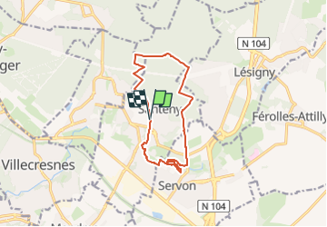
Trail Walking of 11.2 km to be discovered at Ile-de-France, Val-de-Marne, Santeny. This trail is proposed by dmj41.
Description
Voiture jusqu'au point de départ
Positioning
Country:
France
Region :
Ile-de-France
Department/Province :
Val-de-Marne
Municipality :
Santeny
Location:
Unknown
Start:(Dec)
Start:(UTM)
468774 ; 5397783 (31U) N.
Comments
Trails nearby
GRP CV-IDF 05
Walking
Difficult
(1)
Marolles-en-Brie,
Ile-de-France,
Val-de-Marne,
France
3h 27min
No
J 26 Mandres, Boussy , Brunoy le chemin des fresques
Walking
Medium
(2)
Mandres-les-Roses,
Ile-de-France,
Val-de-Marne,
France
12.2 km | 13.8 km-effort
3h 7min
Yes
J 01 11.97 km les 5 châteaux
On foot
Medium
(1)
Servon,
Ile-de-France,
Seine-et-Marne,
France
11.7 km | 13.2 km-effort
3h 3min
Yes
R 04 - 8 km - Servon, Santeny, Servon
On foot
Very difficult
(4)
Servon,
Ile-de-France,
Seine-et-Marne,
France
7.9 km | 9.1 km-effort
2h 3min
Yes
brie comte robert
Walking
Easy
(2)
Brie-Comte-Robert,
Ile-de-France,
Seine-et-Marne,
France
16.7 km | 18.8 km-effort
4h 21min
Yes
BM Foret Regionale de Grobois 10km
Walking
Medium
(1)
Yerres,
Ile-de-France,
Essonne,
France
10.4 km | 11 km-effort
2h 30min
Yes
BM Foret Regionale Grosbois 10km
Walking
Medium
(1)
Yerres,
Ile-de-France,
Essonne,
France
9.8 km | 10.5 km-effort
2h 23min
Yes
L 32: Boussy St Antoine l'Yerres et le Gord
On foot
Very easy
(3)
Boussy-Saint-Antoine,
Ile-de-France,
Essonne,
France
6.2 km | 7.2 km-effort
1h 38min
Yes
JC 24 Servon , Villecresnes, forêt de la Grange
Walking
Difficult
(3)
Servon,
Ile-de-France,
Seine-et-Marne,
France
20 km | 22 km-effort
5h 6min
Yes