Trail Walking Orbey - Du Lac Noir au Gazon du Faing - Photo

Du Lac Noir au Gazon du Faing

© OpenStreetMap contributors
Length
Length
12 km
Max alt
Max alt
1299 m
Uphill gradient
Uphill gradient
538 m
Km-Effort
Km-Effort  
19.2 km
Min alt
Min alt
950 m
Downhill gradient
Downhill gradient
539 m
Boucle
Boucle
Yes
Creation date :
2015-02-20 00:00:00.0
Updated on :
2015-02-20 00:00:00.0

(0 Reviews)

Walking
Walking
4h07
Difficulty : Medium

Scan this QR Code to open this trail in the SityTrail application

FREE GPS app for hiking

Logo SityTrail SityTrail

IGN / Geographical institutes

Download SityTrail from the App Store Download SityTrail from Google Play

Logo SityTrail SityTrail World

The world is yours!

Download SityTrail from the App Store Download SityTrail from Google Play Download SityTrail on Huawei AppGallery

About

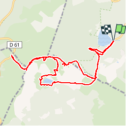
Trail Walking of 12 km to be discovered at Grand Est, Haut-Rhin, Orbey. This trail is proposed by jeanclaude12.

Description

Au départ du Lac Noir, rejoindre l'Altenkraehkopf puis la crête par le Soultzeren Eck. Poursuivre jusqu'au Rocher du Cri du Pigeon (Taubenklangfelsen -1299m) et l'Auberge du Gazon du Faing. Retour vers le Lac Noir par le Soultzeren Eck puis descendre vers le Lac du Forlet ou Lac des Truites pour reprendre le Sentier du départ.

Elevation profile

Photos

Points of interest

Point of interest Soultzeren - Le Taubenklangfelsen - Photo
jeanclaude12
Point of interest Soultzeren - Lac des Truites ou Forlet - Photo
jeanclaude12

Positioning

Country:
France
Region :
Grand Est
Department/Province :
Haut-Rhin
Municipality :
Orbey
Location:
Unknown
Start:(UTM)
358591 ; 5330565 (32U) N.

Trails nearby

Trail Horseback riding Orbey - 2020-06-28 WE Orbey Petit Hohnack Glasborn - Photo
Horseback riding
GUIDE
holtzv

Horseback riding

Difficult
(1)
Orbey, Grand Est, Haut-Rhin, France
22 km | 31 km-effort
4h 5min
Yes
Trail Horseback riding Orbey - 2020-06-27 WE Orbey Noir Gazon Vert Forlet - Photo
Horseback riding
GUIDE
holtzv

Horseback riding

Medium
(1)
Orbey, Grand Est, Haut-Rhin, France
21 km | 30 km-effort
3h 59min
Yes
Trail Walking Stosswihr - Tour du belvedere avec le passage sur les crêtes  - Photo
Walking
ocepee

Walking

Very easy
(2)
Stosswihr, Grand Est, Haut-Rhin, France
8.5 km | 0 m-effort
2h 28min
Yes
Trail Other activity Soultzeren - Totom 4 lacs - Photo
Other activity
dinozore

Other activity

Medium
(1)
Soultzeren, Grand Est, Haut-Rhin, France
15.6 km | 26 km-effort
4h 37min
Yes
Trail Walking Orbey - Le Tour du Lac Blanc par le Rocher Hans et le sentier de crête - Photo
Walking
tracegps

Walking

Difficult
(3)
Orbey, Grand Est, Haut-Rhin, France
4.4 km | 7.7 km-effort
2h 30min
Yes
Trail Walking Le Bonhomme - Tête des faux . - Photo
Walking
heurtinpatrick

Walking

Medium
(1)
Le Bonhomme, Grand Est, Haut-Rhin, France
11.9 km | 16.6 km-effort
3h 46min
Yes
Trail Walking Soultzeren - Tanet-Gazon du faing par lac vert et retour sommet du Tanet - Photo
Walking
ride-in-Elsass

Walking

Medium
(1)
Soultzeren, Grand Est, Haut-Rhin, France
10 km | 15.6 km-effort
4h 24min
Yes
Trail Walking Lapoutroie - 2012-06-16 Marche aux Alisiers Orbey - Photo
Walking
GUIDE
holtzv

Walking

Easy
(2)
Lapoutroie, Grand Est, Haut-Rhin, France
11.1 km | 16.6 km-effort
2h 49min
Yes
Trail Mountain bike Orbey - Lac Blanc  - Têtes des Faux - Photo
Mountain bike
tracegps

Mountain bike

Medium
(1)
Orbey, Grand Est, Haut-Rhin, France
15.3 km | 21 km-effort
1h 0min
Yes


Close
My subscriptions