Trail Walking Elne - ALENYA 66 - entre l'Agouille de la Mar et le Réart - Photo

ALENYA 66 - entre l'Agouille de la Mar et le Réart

 jeff66
jeff66

User

© OpenStreetMap contributors
Length
Length
12.6 km
Max alt
Max alt
16 m
Uphill gradient
Uphill gradient
44 m
Km-Effort
Km-Effort  
13.1 km
Min alt
Min alt
-1 m
Downhill gradient
Downhill gradient
44 m
Boucle
Boucle
Yes
Creation date :
2015-05-21 00:00:00.0
Updated on :
2015-05-21 00:00:00.0

(0 Reviews)

Walking
Walking
1h57
Difficulty : Easy

Scan this QR Code to open this trail in the SityTrail application

FREE GPS app for hiking

Logo SityTrail SityTrail

IGN / Geographical institutes

Download SityTrail from the App Store Download SityTrail from Google Play

Logo SityTrail SityTrail World

The world is yours!

Download SityTrail from the App Store Download SityTrail from Google Play Download SityTrail on Huawei AppGallery

About

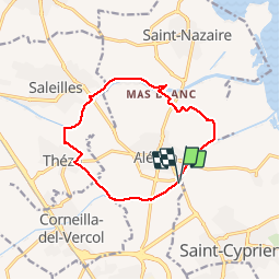
Trail Walking of 12.6 km to be discovered at Occitania, Pyrénées-Orientales, Elne. This trail is proposed by jeff66.

Description

ALENYA 66 - Agouille de la mar - pont del pas del Pilo - pont del pas de la Mar - Mas del Parer - Mas Franc Alleu -  Mas les Ripouilles - le Réart - passage à gué - berges - vue sur les Albères - la Colomina de Canet - SALEILLES - D22 pont sur le Réart - berge opposée - piste cyclable - Mas Tronyo - THEZA - les 4 Aiminades - chemin de Charlemagne - Negabous - Mas de la méridienne - petit mas blanc - les Cent - Mas Chichet - Serres et parc photovoltaïque

Elevation profile

Photos

Positioning

Country:
France
Region :
Occitania
Department/Province :
Pyrénées-Orientales
Municipality :
Elne
Location:
Unknown
Start:(UTM)
499049 ; 4720111 (31T) N.

Trails nearby

Trail Walking Théza - 66 THEZA - CORNEILLA-DEL-VERCOL - Photo
Walking
jeff66

Walking

Easy
(2)
Théza, Occitania, Pyrénées-Orientales, France
7 km | 7.5 km-effort
1h 8min
Yes
Trail Walking Saint-Cyprien - SAINT-CYPRIEN 66 - front de mer - les CAPELLANS - Photo
Walking
jeff66

Walking

Easy
(2)
Saint-Cyprien, Occitania, Pyrénées-Orientales, France
9.9 km | 10.3 km-effort
2h 11min
Yes
Trail Equestrian Saint-Cyprien - bocal du Tech - Photo
Equestrian
sandymocko

Equestrian

Medium
(1)
Saint-Cyprien, Occitania, Pyrénées-Orientales, France
17 km | 17.7 km-effort
3h 20min
Yes
Trail Walking Saleilles - 66 SALEILLES - St-NAZAIRE, entre FOSSEILLE et REART - Photo
Walking
jeff66

Walking

Easy
(1)
Saleilles, Occitania, Pyrénées-Orientales, France
7.3 km | 7.7 km-effort
1h 8min
Yes
Trail Walking Corneilla-del-Vercol - thématique mo tescot du 18 02 2023 - Photo
Walking
66Gribouille83

Walking

Medium
(1)
Corneilla-del-Vercol, Occitania, Pyrénées-Orientales, France
8.9 km | 9.4 km-effort
1h 57min
Yes
Trail Walking Saint-Cyprien - 66 SAINT-CYPRIEN - ALENYA - LATOUR-BAS-ELNE - de berges en berges  - Photo
Walking
jeff66

Walking

Medium
Saint-Cyprien, Occitania, Pyrénées-Orientales, France
7.9 km | 8.3 km-effort
1h 16min
Yes
Trail Walking Saint-Nazaire - 66 SAINT-NAZAIRE - CABESTANY promenade dans le vignoble de galets - Photo
Walking
jeff66

Walking

Medium
Saint-Nazaire, Occitania, Pyrénées-Orientales, France
9 km | 9.9 km-effort
1h 29min
Yes
Trail Walking Montescot - 66 MONTESCOT - ELNE - promenade entre Prairies du Vercol et vignobles des contreforts des Aspres - Photo
Walking
jeff66

Walking

Medium
Montescot, Occitania, Pyrénées-Orientales, France
10.3 km | 11.4 km-effort
1h 41min
Yes
Trail Walking Corneilla-del-Vercol - CORNEILLA-DEL-VERCOL 66 - THEZA - l'Agouille de la Mar - le VERCOL - Photo
Walking
jeff66

Walking

Easy
(1)
Corneilla-del-Vercol, Occitania, Pyrénées-Orientales, France
12.3 km | 13.1 km-effort
2h 12min
Yes


Close
My subscriptions