Trail Walking Saint-Nazaire - 66 SAINT-NAZAIRE - CABESTANY promenade dans le vignoble de galets - Photo

66 SAINT-NAZAIRE - CABESTANY promenade dans le vignoble de galets

 jeff66
jeff66

User

© OpenStreetMap contributors
Length
Length
9 km
Max alt
Max alt
34 m
Uphill gradient
Uphill gradient
65 m
Km-Effort
Km-Effort  
9.9 km
Min alt
Min alt
-1 m
Downhill gradient
Downhill gradient
61 m
Boucle
Boucle
Yes
Creation date :
2015-08-24 00:00:00.0
Updated on :
2015-08-24 00:00:00.0

(0 Reviews)

Walking
Walking
1h29
Difficulty : Medium

Scan this QR Code to open this trail in the SityTrail application

FREE GPS app for hiking

Logo SityTrail SityTrail

IGN / Geographical institutes

Download SityTrail from the App Store Download SityTrail from Google Play

Logo SityTrail SityTrail World

The world is yours!

Download SityTrail from the App Store Download SityTrail from Google Play Download SityTrail on Huawei AppGallery

About

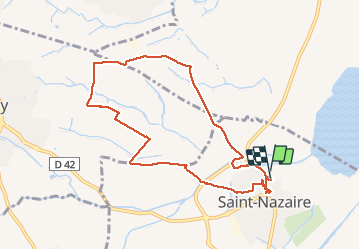
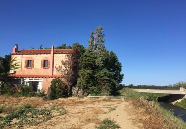
Trail Walking of 9 km to be discovered at Occitania, Pyrénées-Orientales, Saint-Nazaire. This trail is proposed by jeff66.

Description

66 SAINT-NAZAIRE - parking des écoles et halle aux sports, avenue de Canet, camping les flamands roses, station de pompage, Solellop, château de Rey, mas d'en Sisquella, mas Victor, les Portes - Cabestany, chemin de Charlemagne, via Domitia, château de Lacroix, el mas'd'Alla - mas del Moli - SAINT-NAZAIRE, les garrigues, camp d'en Barrera, radier, stade marc-henri Tanyères, domaine de l'Arca, rue des amandiers, avenue de Paris, rue Serrat de madame. Rue de la mairie, rue du maréchal Joffre rue aristide Maillol, rue de l'église

Elevation profile

Photos

Positioning

Country:
France
Region :
Occitania
Department/Province :
Pyrénées-Orientales
Municipality :
Saint-Nazaire
Location:
Unknown
Start:(UTM)
499310 ; 4724252 (31T) N.

Trails nearby

Trail Walking Théza - 66 THEZA - CORNEILLA-DEL-VERCOL - Photo
Walking
jeff66

Walking

Easy
(2)
Théza, Occitania, Pyrénées-Orientales, France
7 km | 7.5 km-effort
1h 8min
Yes
Trail Walking Saint-Cyprien - SAINT-CYPRIEN 66 - front de mer - les CAPELLANS - Photo
Walking
jeff66

Walking

Easy
(2)
Saint-Cyprien, Occitania, Pyrénées-Orientales, France
9.9 km | 10.3 km-effort
2h 11min
Yes
Trail Equestrian Saint-Cyprien - bocal du Tech - Photo
Equestrian
sandymocko

Equestrian

Medium
(1)
Saint-Cyprien, Occitania, Pyrénées-Orientales, France
17 km | 17.7 km-effort
3h 20min
Yes
Trail Walking Cabestany - Chemins autour de Cabestany - Photo
Walking
tracegps

Walking

Medium
(2)
Cabestany, Occitania, Pyrénées-Orientales, France
11.8 km | 12.7 km-effort
3h 0min
Yes
Trail Walking Saleilles - 66 SALEILLES - St-NAZAIRE, entre FOSSEILLE et REART - Photo
Walking
jeff66

Walking

Easy
(1)
Saleilles, Occitania, Pyrénées-Orientales, France
7.3 km | 7.7 km-effort
1h 8min
Yes
Trail Walking Corneilla-del-Vercol - CORNEILLA-DEL-VERCOL 66 - THEZA - l'Agouille de la Mar - le VERCOL - Photo
Walking
jeff66

Walking

Easy
(1)
Corneilla-del-Vercol, Occitania, Pyrénées-Orientales, France
12.3 km | 13.1 km-effort
2h 12min
Yes
Trail Walking Canet-en-Roussillon - CANET-EN-ROUSSILLON 66 - entre TÊT, marais. étang et RÉART  - Photo
Walking
jeff66

Walking

Medium
(1)
Canet-en-Roussillon, Occitania, Pyrénées-Orientales, France
16.3 km | 17.5 km-effort
2h 49min
Yes
Trail Walking Canet-en-Roussillon - CANET-EN-ROUSSILLON 66 - entre mer, plage, dunes et étang - SAINT-CYPRIEN-PLAGE - Photo
Walking
jeff66

Walking

Medium
Canet-en-Roussillon, Occitania, Pyrénées-Orientales, France
12.5 km | 12.9 km-effort
2h 14min
Yes
Trail Walking Elne - ALENYA 66 - entre l'Agouille de la Mar et le Réart - Photo
Walking
jeff66

Walking

Easy
Elne, Occitania, Pyrénées-Orientales, France
12.6 km | 13.1 km-effort
1h 57min
Yes


Close
My subscriptions