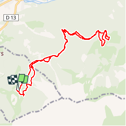
7.4 km | 12.1 km-effort
St Leger les Melezes - Cabane de tante Yvonne
R@ph
User GUIDE
Length
10.8 km
Max alt
1903 m
Uphill gradient
546 m
Km-Effort
18.1 km
Min alt
1650 m
Downhill gradient
562 m
Boucle
Yes
Creation date :
2015-06-22 00:00:00.0
Updated on :
2015-06-22 00:00:00.0
3h54
Difficulty : Difficult
FREE GPS app for hiking
About
Trail Walking of 10.8 km to be discovered at Provence-Alpes-Côte d'Azur, Hautes-Alpes, Saint-Léger-les-Mélèzes. This trail is proposed by R@ph.
Positioning
Country:
France
Region :
Provence-Alpes-Côte d'Azur
Department/Province :
Hautes-Alpes
Municipality :
Saint-Léger-les-Mélèzes
Location:
Unknown
Start:(Dec)
Start:(UTM)
280001 ; 4947161 (32T) N.
Comments
Trails nearby
Circuit de Costebelle
Walking
Very easy
(2)
Saint-Jean-Saint-Nicolas,
Provence-Alpes-Côte d'Azur,
Hautes-Alpes,
France
2h 16min
Yes
Ancelle-Tour du Cuchon
Running
Very easy
(2)
Ancelle,
Provence-Alpes-Côte d'Azur,
Hautes-Alpes,
France
15.4 km | 26 km-effort
3h 15min
Yes
col de la coupa et tour de la rouanne
Walking
Difficult
(1)
Ancelle,
Provence-Alpes-Côte d'Azur,
Hautes-Alpes,
France
16.2 km | 28 km-effort
4h 56min
Yes
L'arche et L'aiguille 01/09/23
Walking
Very difficult
Ancelle,
Provence-Alpes-Côte d'Azur,
Hautes-Alpes,
France
8.6 km | 19.6 km-effort
4h 27min
Yes
Le Piolt par la Pourrachiere 21/07/23
Walking
Very difficult
Ancelle,
Provence-Alpes-Côte d'Azur,
Hautes-Alpes,
France
13.7 km | 25 km-effort
5h 41min
Yes
Le Piolit par Rouanne Haute 27/09/19
Walking
Very difficult
Ancelle,
Provence-Alpes-Côte d'Azur,
Hautes-Alpes,
France
14.2 km | 26 km-effort
5h 15min
Yes
Tour de Pourrachière
Snowshoes
Difficult
(1)
Ancelle,
Provence-Alpes-Côte d'Azur,
Hautes-Alpes,
France
14.9 km | 26 km-effort
6h 0min
No
Pont Ricous Pelissier Coste Belle Pont du Fossé
Walking
Easy
(2)
Saint-Jean-Saint-Nicolas,
Provence-Alpes-Côte d'Azur,
Hautes-Alpes,
France
11.3 km | 21 km-effort
1h 57min
Yes
col pourrachere pour les cools
Walking
Difficult
(1)
Ancelle,
Provence-Alpes-Côte d'Azur,
Hautes-Alpes,
France
9.9 km | 17.4 km-effort
3h 57min
Yes
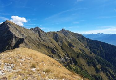
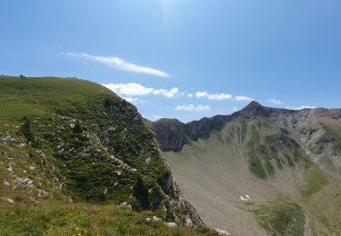
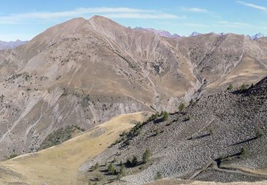
Super petite rando, très agréable à faire en famille. Suivre le Gros 50.