Trail Walking Maury - 66 MAURY - mas Amiel - Promenade dans le vignoble - mas de las Fredes  - Photo

66 MAURY - mas Amiel - Promenade dans le vignoble - mas de las Fredes

 jeff66
jeff66

User

© OpenStreetMap contributors
Length
Length
7.4 km
Max alt
Max alt
224 m
Uphill gradient
Uphill gradient
144 m
Km-Effort
Km-Effort  
9.3 km
Min alt
Min alt
115 m
Downhill gradient
Downhill gradient
141 m
Boucle
Boucle
Yes
Creation date :
2016-04-18 00:00:00.0
Updated on :
2016-04-18 00:00:00.0

(0 Reviews)

Walking
Walking
1h32
Difficulty : Medium

Scan this QR Code to open this trail in the SityTrail application

FREE GPS app for hiking

Logo SityTrail SityTrail

IGN / Geographical institutes

Download SityTrail from the App Store Download SityTrail from Google Play

Logo SityTrail SityTrail World

The world is yours!

Download SityTrail from the App Store Download SityTrail from Google Play Download SityTrail on Huawei AppGallery

About

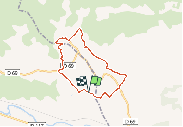
Trail Walking of 7.4 km to be discovered at Occitania, Pyrénées-Orientales, Maury. This trail is proposed by jeff66.

Description

66 MAURY. Promenade vignobles du Mas Amiel, Le Peyssounie, traverser la RD69, Cabirou, RD69a, Mas de l'as Fredes, piste DFCI F93, Traou, camp del Baquié, L ouille

Elevation profile

Points of interest

Point of interest Tautavel - Point 1 - Photo
jeff66
TAUTAVEL 

Positioning

Country:
France
Region :
Occitania
Department/Province :
Pyrénées-Orientales
Municipality :
Maury
Location:
Unknown
Start:(UTM)
472205 ; 4739508 (31T) N.

Trails nearby

Trail Walking Estagel - ESTAGEL Chapelle St Laurent MARDI FAIT - Photo
Walking
MarcOBRECHT

Walking

Medium
Estagel, Occitania, Pyrénées-Orientales, France
12.2 km | 16.9 km-effort
3h 26min
Yes
Trail Walking Latour-de-France - Latour de France 08/12/2021 - Photo
Walking
andre66

Walking

Medium
Latour-de-France, Occitania, Pyrénées-Orientales, France
12.4 km | 16.2 km-effort
3h 12min
Yes
Trail Walking Estagel - 20201216 Estagel - Calce  - Photo
Walking
ThonyM

Walking

Medium
Estagel, Occitania, Pyrénées-Orientales, France
15.8 km | 22 km-effort
3h 36min
Yes
Trail Walking Latour-de-France - 66 LATOUR-DE-FRANCE, visite du village, massif de Tourèze et vallée de l'Agly - Photo
Walking
Phidel66

Walking

Medium
Latour-de-France, Occitania, Pyrénées-Orientales, France
8.3 km | 11 km-effort
1h 47min
Yes
Trail Walking Tautavel - mas amiel - Photo
Walking
Fildesir

Walking

Very easy
Tautavel, Occitania, Pyrénées-Orientales, France
19 km | 24 km-effort
6h 15min
Yes
Trail Walking Planèzes - PLANÈZES (10/10/2017) - Photo
Walking
Richard68500

Walking

Easy
Planèzes, Occitania, Pyrénées-Orientales, France
9.9 km | 13.6 km-effort
3h 0min
Yes
Trail Walking Cucugnan - Cucugnan Quéribus - Photo
Walking
emileverschueren

Walking

Medium
(2)
Cucugnan, Occitania, Aude, France
9.3 km | 15.1 km-effort
3h 14min
Yes
Trail Walking Latour-de-France - au départ de la Tour de France - Photo
Walking
ThonyM

Walking

Easy
Latour-de-France, Occitania, Pyrénées-Orientales, France
19.9 km | 27 km-effort
4h 57min
Yes
Trail Walking Latour-de-France - 66 LATOUR-DE-FRANCE, visite du village, massif de Tourèze et vallée de l'Agly - Photo
Walking
jeff66

Walking

Medium
(1)
Latour-de-France, Occitania, Pyrénées-Orientales, France
8.3 km | 11 km-effort
1h 47min
Yes


Close
My subscriptions