Trail Walking Bagnères-de-Bigorre - Tourmalet pic du midi-fait - Photo

convivialite, sport et fiesta

© OpenStreetMap contributors
Length
Length
14.8 km
Max alt
Max alt
2851 m
Uphill gradient
Uphill gradient
826 m
Km-Effort
Km-Effort  
26 km
Min alt
Min alt
2097 m
Downhill gradient
Downhill gradient
814 m
Boucle
Boucle
Yes
Creation date :
2019-04-29 08:27:14.901
Updated on :
2019-04-29 08:27:14.939

(0 Reviews)

Walking
Walking
5h58
Difficulty : Difficult

Scan this QR Code to open this trail in the SityTrail application

FREE GPS app for hiking

Logo SityTrail SityTrail

IGN / Geographical institutes

Download SityTrail from the App Store Download SityTrail from Google Play

Logo SityTrail SityTrail World

The world is yours!

Download SityTrail from the App Store Download SityTrail from Google Play Download SityTrail on Huawei AppGallery

About

Trail Walking of 14.8 km to be discovered at Occitania, Hautespyrenees, Bagnères-de-Bigorre. This trail is proposed by Lous Passa camins.

Description

départ parking du col du Tourmalet, prendre l'ancienne piste, jusqu’à l'hostellerie.
Apres c'est un peu plus raide mais la récompense est au bout. Allez encore un petit effort.

Elevation profile

Positioning

Country:
France
Region :
Occitania
Department/Province :
Hautespyrenees
Municipality :
Bagnères-de-Bigorre
Location:
Unknown
Start:(UTM)
267061 ; 4754647 (31T) N.

Trails nearby

Trail Walking Campan - Lac d'Arizes - Campan - Photo
Walking
tracegps

Walking

Medium
(1)
Campan, Occitania, Hautespyrenees, France
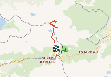
10.2 km | 20 km-effort
3h 30min
Yes
Trail Walking Barèges - Pic des Trois Conseillers - Photo
Walking
tracegps

Walking

Very difficult
(1)
Barèges, Occitania, Hautespyrenees, France
16 km | 34 km-effort
9h 0min
Yes
Trail Walking Barèges - Pic de Madamète en boucle par les lacs - Photo
Walking
tracegps

Walking

Difficult
(1)
Barèges, Occitania, Hautespyrenees, France
21 km | 40 km-effort
9h 0min
Yes
Trail On foot Campan - SityTrail - 2444920 - artigues-la-mongie-g3-lpc-corrigex - Photo
On foot
JACQUESD

On foot

Very easy
(1)
Campan, Occitania, Hautespyrenees, France
7.8 km | 15.7 km-effort
Unknown
Yes
Trail Walking Barèges - En boucle, Grand Tourmalet- Aygues Cluses-Col de Madamète- Lac  Dets Coubous. - Photo
Walking
2034

Walking

Difficult
(3)
Barèges, Occitania, Hautespyrenees, France
16.7 km | 32 km-effort
6h 26min
Yes
Trail Walking Campan - Pic Midi Bigorres - Photo
Walking
doume82

Walking

Difficult
(1)
Campan, Occitania, Hautespyrenees, France
9.2 km | 25 km-effort
4h 30min
No
Trail Horseback riding Sers - Plateau d’Aoube par la cabane d’Aoube - Photo
Horseback riding
orsel

Horseback riding

Easy
Sers, Occitania, Hautespyrenees, France
7.4 km | 15.1 km-effort
4h 43min
Yes
Trail Walking Barèges - le circuit des 5 lacs - Photo
Walking
Vero7684

Walking

Difficult
(2)
Barèges, Occitania, Hautespyrenees, France
13.1 km | 24 km-effort
5h 13min
Yes
Trail On foot Barèges - Grande boucle dans la région du Néouvielle - Photo
On foot
PRO

On foot

Medium
Barèges, Occitania, Hautespyrenees, France
16.5 km | 31 km-effort
7h 1min
Yes


Close
My subscriptions