Trail Walking Saint-Méard-de-Drône - St Méard de Drône - Photo
 swp648
swp648

User

© OpenStreetMap contributors
Length
Length
10.6 km
Max alt
Max alt
165 m
Uphill gradient
Uphill gradient
220 m
Km-Effort
Km-Effort  
13.5 km
Min alt
Min alt
72 m
Downhill gradient
Downhill gradient
218 m
Boucle
Boucle
Yes
Creation date :
2018-04-17 16:24:39.37
Updated on :
2018-04-17 16:24:39.37

(0 Reviews)

Walking
Walking
2h55
Difficulty : Very easy

Scan this QR Code to open this trail in the SityTrail application

FREE GPS app for hiking

Logo SityTrail SityTrail

IGN / Geographical institutes

Download SityTrail from the App Store Download SityTrail from Google Play

Logo SityTrail SityTrail World

The world is yours!

Download SityTrail from the App Store Download SityTrail from Google Play Download SityTrail on Huawei AppGallery

About

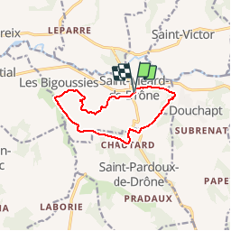
Trail Walking of 10.6 km to be discovered at New Aquitaine, Dordogne, Saint-Méard-de-Drône. This trail is proposed by swp648.

Description

Départ du monument aux morts.
Randonnée bien balisée sans difficulté, beaux chemins, praticables par tous les temps.
La randonnée passe devant le château de Fontenille.

Elevation profile

Positioning

Country:
France
Region :
New Aquitaine
Department/Province :
Dordogne
Municipality :
Saint-Méard-de-Drône
Location:
Unknown
Start:(UTM)
297517 ; 5013692 (31T) N.

Trails nearby

Trail Walking Saint-Victor - 24 Boucle de Saint-Victor  - Photo
Walking
Patxito

Walking

Easy
(1)
Saint-Victor, New Aquitaine, Dordogne, France
11.7 km | 16.1 km-effort
3h 24min
Yes
Trail Walking Montagrier - 2023-03-10_16h37m21_joyeux-randonneurs-a-montagrier-2 - Photo
Walking
swp648

Walking

Difficult
(1)
Montagrier, New Aquitaine, Dordogne, France
10.7 km | 14.5 km-effort
3h 18min
Yes
Trail Walking Montagrier - montagrier - Photo
Walking
ANNIEXAVE

Walking

Medium
Montagrier, New Aquitaine, Dordogne, France
10.5 km | 14.2 km-effort
2h 33min
Yes
Trail Walking Saint-Méard-de-Drône - boucle saint meard sur dronne - Photo
Walking
fab0202

Walking

Easy
Saint-Méard-de-Drône, New Aquitaine, Dordogne, France
10.5 km | 13.5 km-effort
2h 38min
Yes
Trail Walking Douchapt - boucle des fontaines - Photo
Walking
descardm

Walking

Difficult
Douchapt, New Aquitaine, Dordogne, France
10.6 km | 13.7 km-effort
2h 54min
Yes
Trail Walking Saint-Victor - HB étape 4 - Photo
Walking
CASAURANCQ

Walking

Medium
Saint-Victor, New Aquitaine, Dordogne, France
23 km | 30 km-effort
8h 9min
No
Trail Walking Douchapt - Douchapt circuit des 12 fontaines  - Photo
Walking
phil24

Walking

Easy
(1)
Douchapt, New Aquitaine, Dordogne, France
10.4 km | 13.4 km-effort
2h 51min
Yes
Trail Walking Segonzac - tour de segonzac - Photo
Walking
gersimcar

Walking

Easy
Segonzac, New Aquitaine, Dordogne, France
17.2 km | 21 km-effort
5h 50min
Yes


Close
My subscriptions