Trail Walking Veynes - R10   Le tour des Eygaux - Photo

Les Hautes Alpes à découvrir ! GUIDE+

© OpenStreetMap contributors
Length
Length
7.8 km
Max alt
Max alt
972 m
Uphill gradient
Uphill gradient
263 m
Km-Effort
Km-Effort  
11.3 km
Min alt
Min alt
797 m
Downhill gradient
Downhill gradient
263 m
Boucle
Boucle
Yes
Creation date :
2018-03-23 05:41:19.143
Updated on :
2018-10-16 11:46:33.42

(4 Reviews)

Walking
Walking
2h24
Difficulty : Very easy

Scan this QR Code to open this trail in the SityTrail application

FREE GPS app for hiking

Logo SityTrail SityTrail

IGN / Geographical institutes

Download SityTrail from the App Store Download SityTrail from Google Play

Logo SityTrail SityTrail World

The world is yours!

Download SityTrail from the App Store Download SityTrail from Google Play Download SityTrail on Huawei AppGallery

About

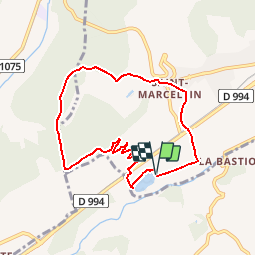
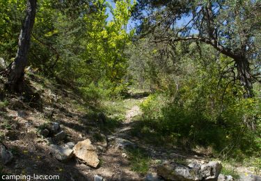
Trail Walking of 7.8 km to be discovered at Provence-Alpes-Côte d'Azur, Hautes-Alpes, Veynes. This trail is proposed by Camping Les Rives du Lac.

Description

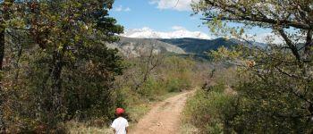
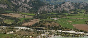
Pleasant hike mostly in the woods, which crosses the 2 trays of Eygaux. Beautiful view of Dévoluy, the Longeagne mountain and the Veynes valley. Famous place for mushrooms in autumn and spring!

Elevation profile

Photos

Points of interest

Point of interest Veynes - Parcours Sportif - Photo
CampingLesRivesduLac
Point of interest Veynes - Vue Dévoluy - Photo
CampingLesRivesduLac
VEYNES 
Point of interest Veynes - Vue Plan d'eau - Photo
CampingLesRivesduLac

Positioning

Country:
France
Region :
Provence-Alpes-Côte d'Azur
Department/Province :
Hautes-Alpes
Municipality :
Veynes
Location:
Unknown
Start:(UTM)
722374 ; 4933343 (31T) N.

Comments

Please log in to post a review or rate the element


Parcours qui grimpe sur 200m quasiment des le début, environ 20 min de montée puis du plat et de la descente sur le reste du trajet. Dommage que le parcours ne puisse être suivi entièrement, car manque d'entretien sur la liaison des 2 "cols" Village de St Marcelin très joli et pitorresque


Trails nearby

Trail Walking Le Saix - R08 La boucle des cascades jaunes - Photo
Walking
GUIDE+

Walking

Very easy
(1)
Le Saix, Provence-Alpes-Côte d'Azur, Hautes-Alpes, France
5.5 km | 10.3 km-effort
2h 10min
Yes
Trail Mountain bike Veynes - VTT29 - Rando famille - Photo
Mountain bike
GUIDE+

Mountain bike

Easy
(1)
Veynes, Provence-Alpes-Côte d'Azur, Hautes-Alpes, France
10.9 km | 13.6 km-effort
54min
Yes
Trail Mountain bike Veynes - VTT14 - Les crêtes de la Longeagne - Photo
Mountain bike
GUIDE+

Mountain bike

Very difficult
(1)
Veynes, Provence-Alpes-Côte d'Azur, Hautes-Alpes, France
39 km | 57 km-effort
3h 15min
Yes
Trail Mountain bike Veynes - VTT03 - Tous les Eygaux - Photo
Mountain bike
GUIDE+

Mountain bike

Medium
(2)
Veynes, Provence-Alpes-Côte d'Azur, Hautes-Alpes, France
23 km | 31 km-effort
1h 31min
Yes
Trail Mountain bike Veynes - VTT02 - Aiguebelle - Photo
Mountain bike
GUIDE+

Mountain bike

Easy
(2)
Veynes, Provence-Alpes-Côte d'Azur, Hautes-Alpes, France
16.7 km | 21 km-effort
1h 23min
Yes
Trail Mountain bike Veynes - VTT01 - Les Eygaux - Photo
Mountain bike
GUIDE+

Mountain bike

Easy
(3)
Veynes, Provence-Alpes-Côte d'Azur, Hautes-Alpes, France
14.1 km | 19.2 km-effort
1h 13min
Yes
Trail Walking Veynes - R09   Le tour de Veynes - Photo
Walking
GUIDE+

Walking

Very easy
(3)
Veynes, Provence-Alpes-Côte d'Azur, Hautes-Alpes, France
9.5 km | 12.3 km-effort
2h 40min
Yes
Trail Walking Le Saix - R07   le fai - Photo
Walking
GUIDE+

Walking

Easy
(4)
Le Saix, Provence-Alpes-Côte d'Azur, Hautes-Alpes, France
5.1 km | 8 km-effort
1h 42min
Yes
Trail Walking Veynes - R06   glaise - Photo
Walking
GUIDE+

Walking

Easy
(1)
Veynes, Provence-Alpes-Côte d'Azur, Hautes-Alpes, France
9.1 km | 14.9 km-effort
3h 4min
Yes


Close
My subscriptions