Trail Mountain bike Munster - Munster: Crêtes du Steinberg - Photo

Munster: Crêtes du Steinberg

 tracegps
tracegps

User

© OpenStreetMap contributors
Length
Length
24 km
Max alt
Max alt
1266 m
Uphill gradient
Uphill gradient
1005 m
Km-Effort
Km-Effort  
37 km
Min alt
Min alt
380 m
Downhill gradient
Downhill gradient
1005 m
Boucle
Boucle
Yes
Creation date :
2014-12-10 00:00:00.0
Updated on :
2014-12-10 00:00:00.0

(0 Reviews)

Mountain bike
Mountain bike
4h00
Difficulty : Difficult

Scan this QR Code to open this trail in the SityTrail application

FREE GPS app for hiking

Logo SityTrail SityTrail

IGN / Geographical institutes

Download SityTrail from the App Store Download SityTrail from Google Play

Logo SityTrail SityTrail World

The world is yours!

Download SityTrail from the App Store Download SityTrail from Google Play Download SityTrail on Huawei AppGallery

About

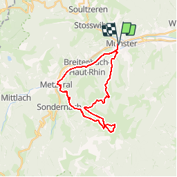
Trail Mountain bike of 24 km to be discovered at Grand Est, Haut-Rhin, Munster. This trail is proposed by tracegps.

Description

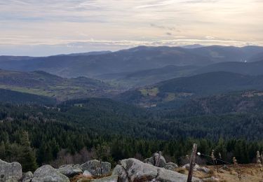
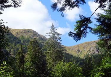
En gros, une montée, une descente, mais quelle descente! La montée est soutenue en raison de la dénivellation. La descente est un beau morceau, surtout au départ du Petit Ballon avec le passage du Steinberg qui est magnifique. La fin de la descente est plus classique et plus roulante. Itinéraire: Au départ du parking de la Gare se diriger vers Metzeral en prenant la route. Depuis Metzeral monter au Rothenbrunnen. Achever la montée jusqu'au Petit Ballon. Redescendre au niveau de la route, la traverser et suivre la Crête du Steinberg. Lorsque le sentier rejoint un bon chemin prendre à droite sur quelques centaines de mètres, puis monter quelques mètres et atteindre un petit col bien marqué qui permet de basculer dans une pente herbeuse. Reprendre le chemin et poursuivre la descente jusqu'à Munster.

Elevation profile

Photos

Positioning

Country:
France
Region :
Grand Est
Department/Province :
Haut-Rhin
Municipality :
Munster
Location:
Unknown
Start:(UTM)
360917 ; 5322282 (32U) N.

Trails nearby

Trail Walking Munster - De Munster aux 3 Fours (Aller) - Munster - Photo
Walking
tracegps

Walking

Difficult
(1)
Munster, Grand Est, Haut-Rhin, France
14.8 km | 27 km-effort
5h 0min
No
Trail Walking Hohrod - Circuit historique 1914-18 Hohrodberg - Linge - Photo
Walking
VacheKiri67

Walking

Medium
(1)
Hohrod, Grand Est, Haut-Rhin, France
14 km | 19.8 km-effort
5h 50min
Yes
Trail Walking Munster - 19.06.13.Munster  - Photo
Walking
ROPPJP

Walking

Very easy
(1)
Munster, Grand Est, Haut-Rhin, France
7.3 km | 10.6 km-effort
2h 10min
Yes
Trail Mountain bike Metzeral - Sentier des Névés - Photo
Mountain bike
tracegps

Mountain bike

Very difficult
(1)
Metzeral, Grand Est, Haut-Rhin, France
33 km | 52 km-effort
6h 0min
Yes
Trail Horseback riding Gunsbach - Le petit Hohnack - verkort (23) - Photo
Horseback riding
eddyvermeulen1

Horseback riding

Easy
(1)
Gunsbach, Grand Est, Haut-Rhin, France
13.1 km | 18.4 km-effort
2h 25min
Yes
Trail Walking Soultzeren - 2022-12-27 Marche Soultzeren Lac Forlet Hautes Huttes Glasborn - Photo
Walking
GUIDE
holtzv

Walking

Very difficult
Soultzeren, Grand Est, Haut-Rhin, France
21 km | 34 km-effort
5h 47min
Yes
Trail Horseback riding Stosswihr - 2018-08-26 Picnic CVA Cascades Stosswihr - Photo
Horseback riding
GUIDE
holtzv

Horseback riding

Easy
Stosswihr, Grand Est, Haut-Rhin, France
19.2 km | 29 km-effort
3min
Yes
Trail Walking Hohrod - Hohrodberg - Le Linge - Photo
Walking
sit68000

Walking

Easy
(2)
Hohrod, Grand Est, Haut-Rhin, France
6.5 km | 10.3 km-effort
2h 2min
Yes
Trail Walking Wasserbourg - Autour de Wasserbourg - Photo
Walking
bob68

Walking

Easy
(1)
Wasserbourg, Grand Est, Haut-Rhin, France
8.8 km | 14 km-effort
2h 6min
Yes


Close
My subscriptions