Trail Walking Saou - Entre Roc et Estang - Photo

Entre Roc et Estang

 tracegps
tracegps

User

© OpenStreetMap contributors
Length
Length
5.2 km
Max alt
Max alt
437 m
Uphill gradient
Uphill gradient
171 m
Km-Effort
Km-Effort  
7.5 km
Min alt
Min alt
329 m
Downhill gradient
Downhill gradient
172 m
Boucle
Boucle
Yes
Creation date :
2014-12-10 00:00:00.0
Updated on :
2014-12-10 00:00:00.0

(1 Reviews)

Walking
Walking
1h15
Difficulty : Medium

Scan this QR Code to open this trail in the SityTrail application

FREE GPS app for hiking

Logo SityTrail SityTrail

IGN / Geographical institutes

Download SityTrail from the App Store Download SityTrail from Google Play

Logo SityTrail SityTrail World

The world is yours!

Download SityTrail from the App Store Download SityTrail from Google Play Download SityTrail on Huawei AppGallery

About

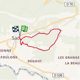
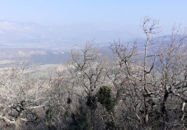
Trail Walking of 5.2 km to be discovered at Auvergne-Rhône-Alpes, Drôme, Saou. This trail is proposed by tracegps.

Description

Jolis points de vues, passage au Pas de l'Estang où ont eu lieu des fouilles révélant les premiers vestiges d'un village édifié en 750 avant JC. Départ du parcours par la rue de l'Houmme, en haut à gauche pour les piétons, à droite en sens inverse pour les vttistes. C'est une rando casse-croûte, plus de détails au gîte du Pré bossu.

Elevation profile

Photos

Positioning

Country:
France
Region :
Auvergne-Rhône-Alpes
Department/Province :
Drôme
Municipality :
Saou
Location:
Unknown
Start:(UTM)
663698 ; 4945779 (31T) N.

Comments

Please log in to post a review or rate the element


Trails nearby

Trail Walking Francillon-sur-Roubion - Balade à francillon sur roubion - description et photos - Photo
Walking
bob2023

Walking

Easy
(1)
Francillon-sur-Roubion, Auvergne-Rhône-Alpes, Drôme, France
5 km | 6.7 km-effort
1h 36min
Yes
Trail Walking Saou - roche Colombe - Photo
Walking
bob2023

Walking

Medium
(1)
Saou, Auvergne-Rhône-Alpes, Drôme, France
10.9 km | 16.8 km-effort
3h 58min
Yes
Trail Walking Saou - Saou Lestang 7 km. - Photo
Walking
chancha

Walking

Medium
(1)
Saou, Auvergne-Rhône-Alpes, Drôme, France
6.6 km | 8.7 km-effort
1h 59min
Yes
Trail Walking Piégros-la-Clastre - Pas de Lauzen Col de la Chaudière - Photo
Walking
denis.benoit

Walking

Very difficult
(1)
Piégros-la-Clastre, Auvergne-Rhône-Alpes, Drôme, France
19.6 km | 42 km-effort
7h 36min
No
Trail Walking Soyans - Soyans 17km - Photo
Walking
GUIDE
thonyc

Walking

Medium
(1)
Soyans, Auvergne-Rhône-Alpes, Drôme, France
15.5 km | 21 km-effort
5h 0min
Yes
Trail Walking Soyans - 26 la repara - Photo
Walking
himba26100

Walking

Medium
Soyans, Auvergne-Rhône-Alpes, Drôme, France
13.6 km | 20 km-effort
5h 12min
Yes
Trail Walking Saou - Saou : petite balade en forêt  - Photo
Walking
Jgar

Walking

Medium
Saou, Auvergne-Rhône-Alpes, Drôme, France
7.4 km | 10.9 km-effort
2h 28min
Yes
Trail Walking Mornans - Mornans-tour de Bezaudun - Photo
Walking
ajd26

Walking

Medium
Mornans, Auvergne-Rhône-Alpes, Drôme, France
17.9 km | 27 km-effort
4h 57min
Yes
Trail Walking Pont-de-Barret - Plateau d'Éson - Photo
Walking
parastat

Walking

Difficult
Pont-de-Barret, Auvergne-Rhône-Alpes, Drôme, France
7.1 km | 12.2 km-effort
2h 44min
Yes


Close
My subscriptions