Trail Walking Saou - Saou : petite balade en forêt  - Photo

Saou : petite balade en forêt

 Jgar
Jgar

User

© OpenStreetMap contributors
Length
Length
7.4 km
Max alt
Max alt
656 m
Uphill gradient
Uphill gradient
259 m
Km-Effort
Km-Effort  
10.9 km
Min alt
Min alt
419 m
Downhill gradient
Downhill gradient
260 m
Boucle
Boucle
Yes
Creation date :
2023-06-21 07:45:17.0
Updated on :
2023-06-26 07:37:38.145

(0 Reviews)

Walking
Walking
2h28
Difficulty : Medium

Scan this QR Code to open this trail in the SityTrail application

FREE GPS app for hiking

Logo SityTrail SityTrail

IGN / Geographical institutes

Download SityTrail from the App Store Download SityTrail from Google Play

Logo SityTrail SityTrail World

The world is yours!

Download SityTrail from the App Store Download SityTrail from Google Play Download SityTrail on Huawei AppGallery

About

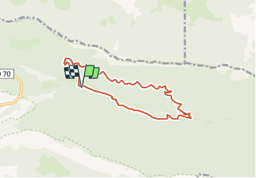
Trail Walking of 7.4 km to be discovered at Auvergne-Rhône-Alpes, Drôme, Saou. This trail is proposed by Jgar.

Description

Parking des Sables Blancs. Traverser la petite route et prendre immédiatement à droite le chemin qui conduit à l'Auberge  des Dauphins. Poursuivre une centaine de mètres et monter à gauche le chemin muletier.
Vers la cote 651, tourner à gauche sur la route forestière et la descendre sur environ 3 km, en suivant les courbes de niveau.  Peu après le sentier qui monte à droite à la chapelle St Médard, bifurquer à gauche afin de redescendre au parking.

Elevation profile

Photos

Positioning

Country:
France
Region :
Auvergne-Rhône-Alpes
Department/Province :
Drôme
Municipality :
Saou
Location:
Unknown
Start:(UTM)
667327 ; 4946990 (31T) N.

Trails nearby

Trail Walking Francillon-sur-Roubion - Balade à francillon sur roubion - description et photos - Photo
Walking
bob2023

Walking

Easy
(1)
Francillon-sur-Roubion, Auvergne-Rhône-Alpes, Drôme, France
5 km | 6.7 km-effort
1h 36min
Yes
Trail Walking Saou - roche Colombe - Photo
Walking
bob2023

Walking

Medium
(1)
Saou, Auvergne-Rhône-Alpes, Drôme, France
10.9 km | 16.8 km-effort
3h 58min
Yes
Trail Walking Saou - saou.les 3 becs - Photo
Walking
Lemichmich

Walking

Difficult
(3)
Saou, Auvergne-Rhône-Alpes, Drôme, France
22 km | 40 km-effort
6h 46min
Yes
Trail Walking Saou - Saou Lestang 7 km. - Photo
Walking
chancha

Walking

Medium
(1)
Saou, Auvergne-Rhône-Alpes, Drôme, France
6.6 km | 8.7 km-effort
1h 59min
Yes
Trail Walking Piégros-la-Clastre - La Chapelle Saint-Médard - Description et vidéo - Photo
Walking
bob2023

Walking

Medium
(1)
Piégros-la-Clastre, Auvergne-Rhône-Alpes, Drôme, France
14.9 km | 25 km-effort
5h 16min
Yes
Trail Walking Piégros-la-Clastre - Pas de Lauzen Col de la Chaudière - Photo
Walking
denis.benoit

Walking

Very difficult
(1)
Piégros-la-Clastre, Auvergne-Rhône-Alpes, Drôme, France
19.6 km | 42 km-effort
7h 36min
No
Trail Walking Saou - Les 3 Becs, le Veyou, le Signal et Rochecourbe - Photo
Walking
tracegps

Walking

Difficult
(3)
Saou, Auvergne-Rhône-Alpes, Drôme, France
18.5 km | 36 km-effort
8h 0min
Yes
Trail Walking Saou - Entre Roc et Estang - Photo
Walking
tracegps

Walking

Medium
(1)
Saou, Auvergne-Rhône-Alpes, Drôme, France
5.2 km | 7.5 km-effort
1h 15min
Yes
Trail Walking Saint-Sauveur-en-Diois - saint sauveur en diois - Photo
Walking
Fanchon_24

Walking

Very easy
Saint-Sauveur-en-Diois, Auvergne-Rhône-Alpes, Drôme, France
5 km | 6.7 km-effort
1h 46min
Yes


Close
My subscriptions