Trail Mountain bike Lautenbach - Espace VTT - FFC Région de Guebwiller - n°07 - Circuit du Dreibannstein  - Photo

Espace VTT - FFC Région de Guebwiller - n°07 - Circuit du Dreibannstein

 tracegps
tracegps

User

© OpenStreetMap contributors
Length
Length
8.2 km
Max alt
Max alt
590 m
Uphill gradient
Uphill gradient
191 m
Km-Effort
Km-Effort  
10.8 km
Min alt
Min alt
484 m
Downhill gradient
Downhill gradient
201 m
Boucle
Boucle
Yes
Creation date :
2014-12-10 00:00:00.0
Updated on :
2014-12-10 00:00:00.0

(0 Reviews)

Mountain bike
Mountain bike
34m
Difficulty : Easy

Scan this QR Code to open this trail in the SityTrail application

FREE GPS app for hiking

Logo SityTrail SityTrail

IGN / Geographical institutes

Download SityTrail from the App Store Download SityTrail from Google Play

Logo SityTrail SityTrail World

The world is yours!

Download SityTrail from the App Store Download SityTrail from Google Play Download SityTrail on Huawei AppGallery

About

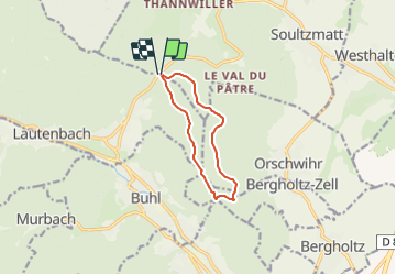
Trail Mountain bike of 8.2 km to be discovered at Grand Est, Haut-Rhin, Lautenbach. This trail is proposed by tracegps.

Description

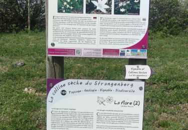
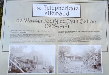
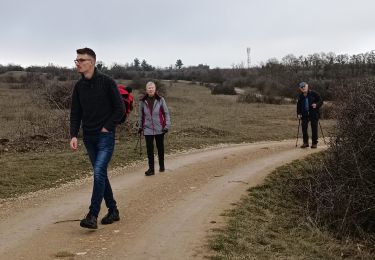
Espace VTT - FFC Région de Guebwiller - n°07 - Circuit du Dreibannstein Circuit officiel labellisé par la Fédération Française de Cyclisme. Départ du Col de Bannstein - Saint Gangolphe – Lautenbach. Entièrement en forêt, ce circuit familial vous permettra une très belle balade, une halte à l’abri du Dreibannstein s’imposera. Bannstein : emplacement d’une borne marquant la limite du ban, en l’occurrence celui de Schweighouse. Dreibannstein : magnifique empreinte que l’organisation politique a pu laisser dans la toponymie : c’est là que se rencontrent les terres de Buhl, Guebwiller et Orschwihr. Topo guide VTT en vente à l’Office du Tourisme de Guebwiller-Soultz et les Pays du Florival - Antenne de Guebwiller - 71 Rue de la République - 68500 – Guebwiller Tel. : 03 89 76 10 63 - Fax :03 89 76 52 72 Crédit photos ; ©Pays d’Art et d’Histoire de la Région de Guebwiller

Elevation profile

Photos

Positioning

Country:
France
Region :
Grand Est
Department/Province :
Haut-Rhin
Municipality :
Lautenbach
Location:
Unknown
Start:(UTM)
365123 ; 5312711 (32T) N.

Trails nearby

Trail Walking Lautenbach - Tour du Petit Ballon - Photo
Walking
VacheKiri67

Walking

Medium
(1)
Lautenbach, Grand Est, Haut-Rhin, France
12.7 km | 20 km-effort
4h 46min
Yes
Trail Walking Osenbach - Osenbach - Sentier des Sols - Photo
Walking
gscheven

Walking

Easy
(1)
Osenbach, Grand Est, Haut-Rhin, France
4.7 km | 6.6 km-effort
3h 0min
Yes
Trail Walking Rouffach - suuntoapp-Hiking-2023-10-22T08-43-15Z - Photo
Walking
GUIDE
holtzv

Walking

Medium
Rouffach, Grand Est, Haut-Rhin, France
19 km | 33 km-effort
7h 34min
Yes
Trail On foot Wasserbourg - Boenlesgrab - Drei Schöpf - Bannwald - Chalet St Hubert - Brunnemaëttlé - Wassmatt - Hansen et retour - Photo
On foot
patrickbeyrath

On foot

Medium
(1)
Wasserbourg, Grand Est, Haut-Rhin, France
10.2 km | 14.2 km-effort
Unknown
Yes
Trail Walking Wasserbourg - SityTrail - Boenlesgrab- Strohberg - Photo
Walking

Walking

Difficult
(1)
Wasserbourg, Grand Est, Haut-Rhin, France
9.6 km | 15.1 km-effort
3h 0min
Yes
Trail Mountain bike Westhalten - Westhalten - Le tour de la vallée Noble - Photo
Mountain bike
sit68000

Mountain bike

Difficult
(1)
Westhalten, Grand Est, Haut-Rhin, France
24 km | 33 km-effort
2h 30min
Yes
Trail Walking Westhalten - WESTHALTEN ZINKOEPHLE - Photo
Walking
MarcOBRECHT

Walking

Medium
Westhalten, Grand Est, Haut-Rhin, France
10.6 km | 15.3 km-effort
2h 56min
Yes
Trail Walking Rouffach - Boenlesgrab - Ried (14.03.2024) - Photo
Walking
Richard68500

Walking

Medium
Rouffach, Grand Est, Haut-Rhin, France
10.2 km | 15.3 km-effort
3h 28min
Yes
Trail Walking Westhalten - Westhalten - Rouffach  - Photo
Walking
Richard68500

Walking

Difficult
Westhalten, Grand Est, Haut-Rhin, France
8.9 km | 13 km-effort
3h 22min
Yes


Close
My subscriptions