Trail Walking Wasserbourg - SityTrail - Boenlesgrab- Strohberg - Photo

SityTrail - Boenlesgrab- Strohberg

Jetz geht's wieder los, noch dem bloede COVID19

© OpenStreetMap contributors
Length
Length
9.6 km
Max alt
Max alt
1150 m
Uphill gradient
Uphill gradient
410 m
Km-Effort
Km-Effort  
15.1 km
Min alt
Min alt
834 m
Downhill gradient
Downhill gradient
403 m
Boucle
Boucle
Yes
Creation date :
2020-07-20 17:03:26.216
Updated on :
2020-07-20 17:18:07.237

(1 Reviews)

Walking
Walking
3h00
Difficulty : Difficult

Scan this QR Code to open this trail in the SityTrail application

FREE GPS app for hiking

Logo SityTrail SityTrail

IGN / Geographical institutes

Download SityTrail from the App Store Download SityTrail from Google Play

Logo SityTrail SityTrail World

The world is yours!

Download SityTrail from the App Store Download SityTrail from Google Play Download SityTrail on Huawei AppGallery

About

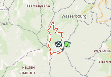
Trail Walking of 9.6 km to be discovered at Grand Est, Haut-Rhin, Wasserbourg. This trail is proposed by Seppala - Balades du jeudi.

Description

Une balade en altitude vers la ferme auberge du Strohberg, près du Petit Ballon.
               Dénivelé de 408 m et distance totale de 9.2 km.
               Si le beau temps se maintient nous pourrons manger dehors.

ACCÈS :
-Par Guebwiller => Lautenbach =>puis la petite route à droite après la scierie en direction du petit Ballon .


PARKING :
-Au col du Boenlesgrab.
47.97679, 7.147654  ou  
N 47°58'36", E 07°08'52"

RESTAURATION :      
Ferme auberge du Strohberg.
Tél: 03 89 77 56 00


Elevation profile

Positioning

Country:
France
Region :
Grand Est
Department/Province :
Haut-Rhin
Municipality :
Wasserbourg
Location:
Unknown
Start:(UTM)
361786 ; 5315356 (32T) N.

Comments

Please log in to post a review or rate the element


Trails nearby

Trail Walking Lautenbach - Tour du Petit Ballon - Photo
Walking
VacheKiri67

Walking

Medium
(1)
Lautenbach, Grand Est, Haut-Rhin, France
12.7 km | 20 km-effort
4h 46min
Yes
Trail Walking Linthal - Tour de la grande Vallée de Munster (refuge du Hilsen - Munster) - Photo
Walking
tracegps

Walking

Difficult
(1)
Linthal, Grand Est, Haut-Rhin, France
18.1 km | 24 km-effort
5h 0min
No
Trail Walking Lautenbachzell - Le Markstein - Photo
Walking
tracegps

Walking

Difficult
(1)
Lautenbachzell, Grand Est, Haut-Rhin, France
22 km | 35 km-effort
6h 0min
Yes
Trail Walking Rouffach - suuntoapp-Hiking-2023-10-22T08-43-15Z - Photo
Walking
GUIDE
holtzv

Walking

Medium
Rouffach, Grand Est, Haut-Rhin, France
19 km | 33 km-effort
7h 34min
Yes
Trail Walking Linthal - SityTrail - Remspach-Hilsen - Photo
Walking

Walking

Medium
(1)
Linthal, Grand Est, Haut-Rhin, France
9.9 km | 14.6 km-effort
3h 3min
Yes
Trail On foot Wasserbourg - Boenlesgrab - Drei Schöpf - Bannwald - Chalet St Hubert - Brunnemaëttlé - Wassmatt - Hansen et retour - Photo
On foot
patrickbeyrath

On foot

Medium
(1)
Wasserbourg, Grand Est, Haut-Rhin, France
10.2 km | 14.2 km-effort
Unknown
Yes
Trail Walking Wasserbourg - Autour de Wasserbourg - Photo
Walking
bob68

Walking

Easy
(1)
Wasserbourg, Grand Est, Haut-Rhin, France
8.8 km | 14 km-effort
2h 6min
Yes
Trail Walking Rouffach - Boenlesgrab - Ried (14.03.2024) - Photo
Walking
Richard68500

Walking

Medium
Rouffach, Grand Est, Haut-Rhin, France
10.2 km | 15.3 km-effort
3h 28min
Yes
Trail Walking Linthal - Hilsen-Petit Ballon-Hilsen - Photo
Walking
griffet

Walking

Medium
Linthal, Grand Est, Haut-Rhin, France
9.5 km | 14.1 km-effort
3h 27min
Yes


Close
My subscriptions