Trail Walking Mimet - Mimet - Photo
 tracegps
tracegps

User

© OpenStreetMap contributors
Length
Length
4.9 km
Max alt
Max alt
591 m
Uphill gradient
Uphill gradient
231 m
Km-Effort
Km-Effort  
8 km
Min alt
Min alt
420 m
Downhill gradient
Downhill gradient
231 m
Boucle
Boucle
Yes
Creation date :
2014-12-10 00:00:00.0
Updated on :
2014-12-10 00:00:00.0

(0 Reviews)

Walking
Walking
2h49
Difficulty : Difficult

Scan this QR Code to open this trail in the SityTrail application

FREE GPS app for hiking

Logo SityTrail SityTrail

IGN / Geographical institutes

Download SityTrail from the App Store Download SityTrail from Google Play

Logo SityTrail SityTrail World

The world is yours!

Download SityTrail from the App Store Download SityTrail from Google Play Download SityTrail on Huawei AppGallery

About

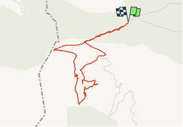
Trail Walking of 4.9 km to be discovered at Provence-Alpes-Côte d'Azur, Bouches-du-Rhône, Mimet. This trail is proposed by tracegps.

Description

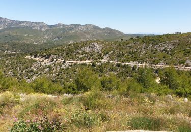
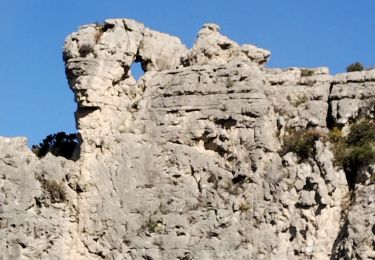
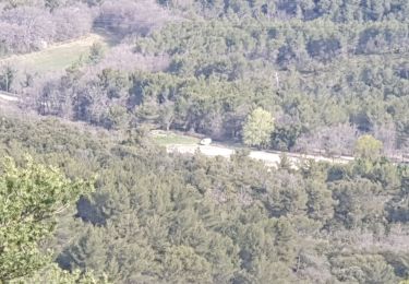
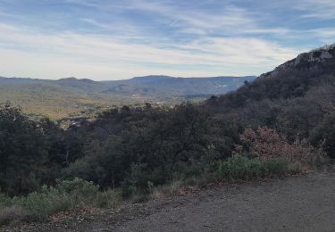
Du goudron au début qui cède vite la place à un chemin qui lui-même cède la place à un sentier qu'il faut plus ou moins "franchir" plus que "parcourir" dès le 3e kilomètre. Là, ça devient un peu physique comme l'indique clairement la carte de dénivelé, en bas de cette page. Cette sortie laisse un sentiment d’émerveillement devant une si belle nature, un point de vue si extraordinaire que gâche à peine ... tous ces poteaux électriques qui balafrent ce lieu si magnifique.

Elevation profile

Photos

Positioning

Country:
France
Region :
Provence-Alpes-Côte d'Azur
Department/Province :
Bouches-du-Rhône
Municipality :
Mimet
Location:
Unknown
Start:(UTM)
701680 ; 4809442 (31T) N.

Trails nearby

Trail Walking Allauch - Le tour des Grands Ubacs au départ de Pichauris - Photo
Walking
Coqorico

Walking

Easy
(1)
Allauch, Provence-Alpes-Côte d'Azur, Bouches-du-Rhône, France
13.3 km | 20 km-effort
4h 25min
Yes
Trail Walking Allauch - Domaine de Pichauris - Allauch - Photo
Walking
tracegps

Walking

Medium
(1)
Allauch, Provence-Alpes-Côte d'Azur, Bouches-du-Rhône, France
10.5 km | 15 km-effort
2h 30min
Yes
Trail Walking Allauch - le pic du Taoumé par Pichauris - Photo
Walking
GUIDE
amiral13

Walking

Easy
Allauch, Provence-Alpes-Côte d'Azur, Bouches-du-Rhône, France
13.3 km | 20 km-effort
4h 32min
Yes
Trail Mountain bike Allauch - les antennes du garlaban à modifier - Photo
Mountain bike
GUIDE
harydh

Mountain bike

Medium
Allauch, Provence-Alpes-Côte d'Azur, Bouches-du-Rhône, France
19.3 km | 28 km-effort
2h 8min
Yes
Trail Mountain bike Allauch - les antennes du garlaban - Photo
Mountain bike
GUIDE
harydh

Mountain bike

Medium
Allauch, Provence-Alpes-Côte d'Azur, Bouches-du-Rhône, France
19.3 km | 28 km-effort
2h 8min
Yes
Trail Mountain bike Allauch - de Pichauris au mont du Marseillais - Photo
Mountain bike
GUIDE
amiral13

Mountain bike

Medium
Allauch, Provence-Alpes-Côte d'Azur, Bouches-du-Rhône, France
14 km | 19.2 km-effort
2h 34min
Yes
Trail Walking Allauch - N D des Anges massif de l'étoile - Photo
Walking
cousam

Walking

Medium
Allauch, Provence-Alpes-Côte d'Azur, Bouches-du-Rhône, France
13.1 km | 19.5 km-effort
6h 51min
Yes
Trail Electric bike Simiane-Collongue - LES MARRES PILON DU ROI - Photo
Electric bike
GUIDE
harydh

Electric bike

Easy
Simiane-Collongue, Provence-Alpes-Côte d'Azur, Bouches-du-Rhône, France
26 km | 36 km-effort
2h 18min
Yes
Trail Walking Saint-Savournin - St Savourin Col Ste Anne - Photo
Walking
sereton

Walking

Medium
Saint-Savournin, Provence-Alpes-Côte d'Azur, Bouches-du-Rhône, France
9.2 km | 15.2 km-effort
2h 59min
Yes


Close
My subscriptions