Trail Walking Metzeral - Sentier de Giesenbach - Photo

Sentier de Giesenbach

© OpenStreetMap contributors
Length
Length
5.7 km
Max alt
Max alt
780 m
Uphill gradient
Uphill gradient
300 m
Km-Effort
Km-Effort  
9.7 km
Min alt
Min alt
494 m
Downhill gradient
Downhill gradient
299 m
Boucle
Boucle
Yes
Creation date :
2014-12-10 00:00:00.0
Updated on :
2014-12-10 00:00:00.0

(0 Reviews)

Walking
Walking
2h06
Difficulty : Easy

Scan this QR Code to open this trail in the SityTrail application

FREE GPS app for hiking

Logo SityTrail SityTrail

IGN / Geographical institutes

Download SityTrail from the App Store Download SityTrail from Google Play

Logo SityTrail SityTrail World

The world is yours!

Download SityTrail from the App Store Download SityTrail from Google Play Download SityTrail on Huawei AppGallery

About

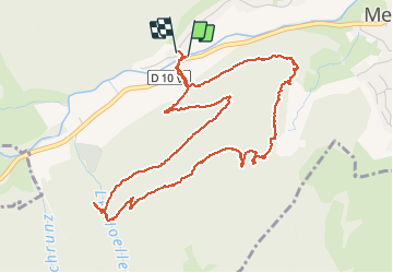
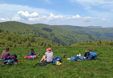
Trail Walking of 5.7 km to be discovered at Grand Est, Haut-Rhin, Metzeral. This trail is proposed by neoroll44.

Description

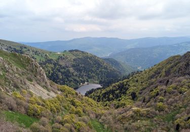
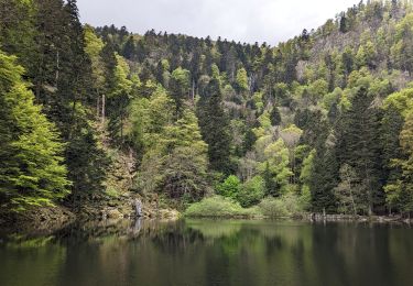
De Steinabrück, prendre le chemin en face. Monter à droite le sentier vers Schnepfenried. Marquer une pause à la stèle en hommage au capitaine mort en 1915. Descendre par le sentier panoramique de Giesensebach (superbe vue sur la vallée de la Wormsa, ses chalets, le Gaschney, le massif du Honneck. Plus tard, prendre à droite le sentier qui remonte un peu puis vous ramène au départ. Prenez une pause à l'auberge de la Wormsa.

Elevation profile

Photos

Positioning

Country:
France
Region :
Grand Est
Department/Province :
Haut-Rhin
Municipality :
Metzeral
Location:
Unknown
Start:(UTM)
354891 ; 5319321 (32U) N.

Trails nearby

Trail Walking La Bresse - Du Hohneck au Kastelberg par les Spietzkoepfe et le Sentier des Névées - Photo
Walking
tracegps

Walking

Very difficult
(3)
La Bresse, Grand Est, Vosges, France
7.6 km | 13.7 km-effort
3h 30min
Yes
Trail Mountain bike Metzeral - Sentier des Névés - Photo
Mountain bike
tracegps

Mountain bike

Very difficult
(1)
Metzeral, Grand Est, Haut-Rhin, France
33 km | 52 km-effort
6h 0min
Yes
Trail Walking Mittlach - 2023-09-24 Marche Mittlach 5 Lacs - Photo
Walking
GUIDE
holtzv

Walking

Medium
Mittlach, Grand Est, Haut-Rhin, France
25 km | 41 km-effort
9h 19min
Yes
Trail Walking Sondernach - 2023-05-19 WE Marche Bivouac Massif du Hohneck - Photo
Walking
GUIDE
holtzv

Walking

Medium
Sondernach, Grand Est, Haut-Rhin, France
46 km | 73 km-effort
16h 41min
Yes
Trail Walking Metzeral - 2023-05-21 Marche Firstmiss vers Schnepfenried - Photo
Walking
GUIDE
holtzv

Walking

Medium
Metzeral, Grand Est, Haut-Rhin, France
15.4 km | 22 km-effort
5h 6min
No
Trail Walking Metzeral - 2023-05-20 Marche Lac Fischboedle vers Firstmiss - Photo
Walking
GUIDE
holtzv

Walking

Medium
Metzeral, Grand Est, Haut-Rhin, France
21 km | 37 km-effort
8h 20min
No
Trail Walking Sondernach - 2023-05-19 Marche Schnepfenried vers Lac du Fischboedle - Photo
Walking
GUIDE
holtzv

Walking

Easy
Sondernach, Grand Est, Haut-Rhin, France
9.1 km | 14.1 km-effort
3h 12min
No
Trail Walking Sondernach - 2020-01-02 Marche Landersen Petit Ballon - Photo
Walking
GUIDE
holtzv

Walking

Difficult
Sondernach, Grand Est, Haut-Rhin, France
17.6 km | 28 km-effort
3h 4min
Yes
Trail Walking La Bresse - hohneck  - Photo
Walking
gerard70

Walking

Very easy
(1)
La Bresse, Grand Est, Vosges, France
18.4 km | 28 km-effort
6h 43min
Yes


Close
My subscriptions