Trail Walking Orgon - ORGON (13)  L' Adeline - Photo
 Manoune
Manoune

User

© OpenStreetMap contributors
Length
Length
17.3 km
Max alt
Max alt
298 m
Uphill gradient
Uphill gradient
357 m
Km-Effort
Km-Effort  
22 km
Min alt
Min alt
86 m
Downhill gradient
Downhill gradient
357 m
Boucle
Boucle
Yes
Creation date :
2021-05-13 06:38:47.861
Updated on :
2021-05-13 19:15:33.867

(0 Reviews)

Walking
Walking
5h45
Difficulty : Medium

Scan this QR Code to open this trail in the SityTrail application

FREE GPS app for hiking

Logo SityTrail SityTrail

IGN / Geographical institutes

Download SityTrail from the App Store Download SityTrail from Google Play

Logo SityTrail SityTrail World

The world is yours!

Download SityTrail from the App Store Download SityTrail from Google Play Download SityTrail on Huawei AppGallery

About

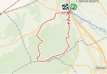
Trail Walking of 17.3 km to be discovered at Provence-Alpes-Côte d'Azur, Bouches-du-Rhône, Orgon. This trail is proposed by Manoune.

Description

Départ de la Place du Four  à Chaux ( boulodrome),.
Ch.de Guise, N. Dame de Beauregard, Vallée Heureuse, les Plaines, L'Adeline, rue Jean Moulin, Montée du Paradis, Ecomusée,
Rue de la Fontaine, rue Jean Moutte, parking.

Elevation profile

Photos

Positioning

Country:
France
Region :
Provence-Alpes-Côte d'Azur
Department/Province :
Bouches-du-Rhône
Municipality :
Orgon
Location:
Unknown
Start:(UTM)
664360 ; 4850586 (31T) N.

Trails nearby

Trail Cycle Cavaillon - Autour du Luberon à vélo - Photo
Cycle
GUIDE+

Cycle

Difficult
(4)
Cavaillon, Provence-Alpes-Côte d'Azur, Vaucluse, France
236 km | 285 km-effort
15h 46min
Yes
Trail Cycle Cavaillon - Parcours n°3 - Cavaillon - Photo
Cycle
GUIDE+

Cycle

Easy
(2)
Cavaillon, Provence-Alpes-Côte d'Azur, Vaucluse, France
45 km | 50 km-effort
2h 55min
No
Trail Cycle Cavaillon - Parcours n°1 - Cavaillon - Photo
Cycle
GUIDE+

Cycle

Difficult
(2)
Cavaillon, Provence-Alpes-Côte d'Azur, Vaucluse, France
33 km | 41 km-effort
2h 21min
Yes
Trail Walking Orgon - plan Orgon di19mai2013 - Photo
Walking
tvtv84

Walking

Easy
(2)
Orgon, Provence-Alpes-Côte d'Azur, Bouches-du-Rhône, France
16 km | 18.8 km-effort
4h 28min
Yes
Trail Walking Taillades - taillades - Photo
Walking
fireman84

Walking

Very easy
(1)
Taillades, Provence-Alpes-Côte d'Azur, Vaucluse, France
7.6 km | 9.8 km-effort
1h 36min
Yes
Trail Walking Orgon - Orgon-vallée heureuse - Photo
Walking
Berpav

Walking

Difficult
(1)
Orgon, Provence-Alpes-Côte d'Azur, Bouches-du-Rhône, France
10.7 km | 13.4 km-effort
2h 27min
Yes
Trail Walking Taillades - Taillades Badarel  Brayette Robion - Photo
Walking
kephas

Walking

Difficult
(1)
Taillades, Provence-Alpes-Côte d'Azur, Vaucluse, France
10.6 km | 17.6 km-effort
3h 41min
Yes
Trail Walking Cheval-Blanc - bergerie/badarel - Photo
Walking
fireman84

Walking

Medium
(1)
Cheval-Blanc, Provence-Alpes-Côte d'Azur, Vaucluse, France
9.9 km | 16 km-effort
3h 20min
Yes
Trail Mountain bike Cheval-Blanc - Cheval-Blanc  - Photo
Mountain bike
nikos2904

Mountain bike

Medium
(2)
Cheval-Blanc, Provence-Alpes-Côte d'Azur, Vaucluse, France
22 km | 29 km-effort
2h 16min
Yes


Close
My subscriptions