Trail Walking Saou - Forêt de Saoù - Saint-Médard - Photo

Forêt de Saoù - Saint-Médard

© OpenStreetMap contributors
Length
Length
13.6 km
Max alt
Max alt
833 m
Uphill gradient
Uphill gradient
678 m
Km-Effort
Km-Effort  
23 km
Min alt
Min alt
431 m
Downhill gradient
Downhill gradient
684 m
Boucle
Boucle
Yes
Creation date :
2022-01-29 07:32:44.047
Updated on :
2022-01-30 10:17:00.809

(0 Reviews)

Walking
Walking
4h00
Difficulty : Medium

Scan this QR Code to open this trail in the SityTrail application

FREE GPS app for hiking

Logo SityTrail SityTrail

IGN / Geographical institutes

Download SityTrail from the App Store Download SityTrail from Google Play

Logo SityTrail SityTrail World

The world is yours!

Download SityTrail from the App Store Download SityTrail from Google Play Download SityTrail on Huawei AppGallery

About

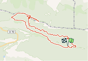
Trail Walking of 13.6 km to be discovered at Auvergne-Rhône-Alpes, Drôme, Saou. This trail is proposed by Philindy26.

Description

Départ du parking de l'Auberge des Dauphins à la Forêt de Saoû...
Géolocalisation (Google Maps) : https://goo.gl/maps/n9WSV1FFqF7iZS4p6

Monter par le sentier des Muletiers (650m) et prendre la piste à la descente jusqu'aux Chênes Est (500m) 1er accès à la chapelle par le Pas Long. Où continuer sur les Chênes (500m) et la Ferme Raillon pour prendre le Pas Court (690m).
Là vous pouvez rejoindre la Chapelle Saint-Médard (858m) en un aller-retour.
Le retour s'effectue par le Pas Court (692 m). le Pas St Michel (732 m), le Pas de Faucon (670 m), puis descente pour rejoindre les ruines de la Ferme Fuoc (460m).
De là continuer jusqu'au virage Raillon (470m) et prendre le sentier qui rejoint la carrière de sables blancs (450m) et les ruines de Pézillet (440m).
Enfin, prendre la direction des ruines de Brunel (450m).
Là descendre pour rejoindre la Voie Cyclable.
Retour à l'Auberge des Dauphins en empruntant le passage à gué (440m) et suivre la Voie Vélo Verte...

Elevation profile

Photos

Positioning

Country:
France
Region :
Auvergne-Rhône-Alpes
Department/Province :
Drôme
Municipality :
Saou
Location:
Unknown
Start:(UTM)
668962 ; 4946509 (31T) N.

Trails nearby

Trail Walking Francillon-sur-Roubion - Balade à francillon sur roubion - description et photos - Photo
Walking
bob2023

Walking

Easy
(1)
Francillon-sur-Roubion, Auvergne-Rhône-Alpes, Drôme, France
5 km | 6.7 km-effort
1h 36min
Yes
Trail Walking Saou - roche Colombe - Photo
Walking
bob2023

Walking

Medium
(1)
Saou, Auvergne-Rhône-Alpes, Drôme, France
10.9 km | 16.8 km-effort
3h 58min
Yes
Trail Walking Saou - saou.les 3 becs - Photo
Walking
Lemichmich

Walking

Difficult
(3)
Saou, Auvergne-Rhône-Alpes, Drôme, France
22 km | 40 km-effort
6h 46min
Yes
Trail Walking Piégros-la-Clastre - Pas de Lauzen Col de la Chaudière - Photo
Walking
denis.benoit

Walking

Very difficult
(1)
Piégros-la-Clastre, Auvergne-Rhône-Alpes, Drôme, France
19.6 km | 42 km-effort
7h 36min
No
Trail Walking Saou - Les 3 Becs, le Veyou, le Signal et Rochecourbe - Photo
Walking
tracegps

Walking

Difficult
(3)
Saou, Auvergne-Rhône-Alpes, Drôme, France
18.5 km | 36 km-effort
8h 0min
Yes
Trail Walking Saint-Sauveur-en-Diois - saint sauveur en diois - Photo
Walking
Fanchon_24

Walking

Very easy
Saint-Sauveur-en-Diois, Auvergne-Rhône-Alpes, Drôme, France
5 km | 6.7 km-effort
1h 46min
Yes
Trail Walking Aubenasson - saint Michel Aubenasson - Photo
Walking
Fanchon_24

Walking

Medium
Aubenasson, Auvergne-Rhône-Alpes, Drôme, France
19.7 km | 24 km-effort
3h 45min
No
Trail Walking Saou - Saou : petite balade en forêt  - Photo
Walking
Jgar

Walking

Medium
Saou, Auvergne-Rhône-Alpes, Drôme, France
7.4 km | 10.9 km-effort
2h 28min
Yes
Trail Walking Bézaudun-sur-Bîne - Fonderesse - Photo
Walking
AIGUIER

Walking

Difficult
Bézaudun-sur-Bîne, Auvergne-Rhône-Alpes, Drôme, France
13.8 km | 22 km-effort
27h 34min
Yes


Close
My subscriptions