Trail Mountain bike Cheval-Blanc - 2022-03-04_10h01m33_vttpll-38-cheval-blanc-au-pied-de-valloncourt - Photo

2022-03-04_10h01m33_vttpll-38-cheval-blanc-au-pied-de-valloncourt

 denel
denel

User

© OpenStreetMap contributors
Length
Length
6 km
Max alt
Max alt
143 m
Uphill gradient
Uphill gradient
74 m
Km-Effort
Km-Effort  
7 km
Min alt
Min alt
97 m
Downhill gradient
Downhill gradient
74 m
Boucle
Boucle
Yes
Creation date :
2022-03-04 09:01:33.906
Updated on :
2022-03-17 12:06:26.109

(0 Reviews)

Mountain bike
Mountain bike
29m
Difficulty : Easy

Scan this QR Code to open this trail in the SityTrail application

FREE GPS app for hiking

Logo SityTrail SityTrail

IGN / Geographical institutes

Download SityTrail from the App Store Download SityTrail from Google Play

Logo SityTrail SityTrail World

The world is yours!

Download SityTrail from the App Store Download SityTrail from Google Play Download SityTrail on Huawei AppGallery

About

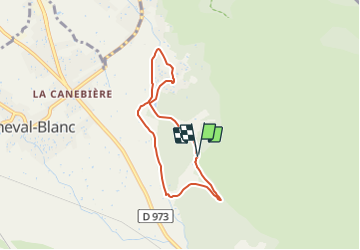
Trail Mountain bike of 6 km to be discovered at Provence-Alpes-Côte d'Azur, Vaucluse, Cheval-Blanc. This trail is proposed by denel.

Description

Une mi-boucle idéale pour faire ses premiers tours de roues à VTT. L'ombre des sous-bois et la fraîcheur du bord de canal d'irrigation sont forts appréciables par forte chaleur.
# difficulté : VERT (très facile).
# départ : parking de Valloncourt (situé à 2,5 km au sud-est du village de Cheval-Blanc).
ATTENTION : bien maîtriser sa trajectoire sur le sentier qui surplombe le canal.

Elevation profile

Positioning

Country:
France
Region :
Provence-Alpes-Côte d'Azur
Department/Province :
Vaucluse
Municipality :
Cheval-Blanc
Location:
Unknown
Start:(UTM)
668341 ; 4851471 (31T) N.

Trails nearby

Trail Cycle Cavaillon - Autour du Luberon à vélo - Photo
Cycle
GUIDE+

Cycle

Difficult
(4)
Cavaillon, Provence-Alpes-Côte d'Azur, Vaucluse, France
236 km | 285 km-effort
15h 46min
Yes
Trail Cycle Cavaillon - Parcours n°3 - Cavaillon - Photo
Cycle
GUIDE+

Cycle

Easy
(2)
Cavaillon, Provence-Alpes-Côte d'Azur, Vaucluse, France
45 km | 50 km-effort
2h 55min
No
Trail Cycle Cavaillon - Parcours n°1 - Cavaillon - Photo
Cycle
GUIDE+

Cycle

Difficult
(2)
Cavaillon, Provence-Alpes-Côte d'Azur, Vaucluse, France
33 km | 41 km-effort
2h 21min
Yes
Trail Walking Taillades - Par la Gorge de Badarel et les Rochers de Baude - Photo
Walking
tracegps

Walking

Medium
(3)
Taillades, Provence-Alpes-Côte d'Azur, Vaucluse, France
8 km | 14.7 km-effort
4h 0min
Yes
Trail Walking Taillades - taillades - Photo
Walking
fireman84

Walking

Very easy
(1)
Taillades, Provence-Alpes-Côte d'Azur, Vaucluse, France
7.6 km | 9.8 km-effort
1h 36min
Yes
Trail Walking Taillades - Les Taillades-De la source du Boulon au Castelas - Gorge de Badarel sous la neige - Photo
Walking
tracegps

Walking

Difficult
(1)
Taillades, Provence-Alpes-Côte d'Azur, Vaucluse, France
7 km | 10.8 km-effort
3h 0min
Yes
Trail Walking Orgon - Orgon-vallée heureuse - Photo
Walking
Berpav

Walking

Difficult
(1)
Orgon, Provence-Alpes-Côte d'Azur, Bouches-du-Rhône, France
10.7 km | 13.4 km-effort
2h 27min
Yes
Trail Mountain bike Maubec - Luberon - Grande Traversée de Vaucluse - de Maubec / Robion à Mérindol - Photo
Mountain bike
GUIDE+

Mountain bike

Difficult
(1)
Maubec, Provence-Alpes-Côte d'Azur, Vaucluse, France
32 km | 42 km-effort
2h 47min
No
Trail Walking Taillades - Taillades Badarel  Brayette Robion - Photo
Walking
kephas

Walking

Difficult
(1)
Taillades, Provence-Alpes-Côte d'Azur, Vaucluse, France
10.6 km | 17.6 km-effort
3h 41min
Yes


Close
My subscriptions