Trail Walking Saint-Antonin-sur-Bayon - La Sainte-Victoire par la brèche du Clapier - Photo

La Sainte-Victoire par la brèche du Clapier

 ARVIEU
ARVIEU

User

© OpenStreetMap contributors
Length
Length
9.7 km
Max alt
Max alt
973 m
Uphill gradient
Uphill gradient
713 m
Km-Effort
Km-Effort  
19.2 km
Min alt
Min alt
436 m
Downhill gradient
Downhill gradient
712 m
Boucle
Boucle
Yes
Creation date :
2024-03-14 12:20:46.58
Updated on :
2024-03-14 12:25:57.035

(0 Reviews)

Walking
Walking
5h30
Difficulty : Very difficult

Scan this QR Code to open this trail in the SityTrail application

FREE GPS app for hiking

Logo SityTrail SityTrail

IGN / Geographical institutes

Download SityTrail from the App Store Download SityTrail from Google Play

Logo SityTrail SityTrail World

The world is yours!

Download SityTrail from the App Store Download SityTrail from Google Play Download SityTrail on Huawei AppGallery

About

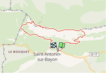
Trail Walking of 9.7 km to be discovered at Provence-Alpes-Côte d'Azur, Bouches-du-Rhône, Saint-Antonin-sur-Bayon. This trail is proposed by ARVIEU.

Description

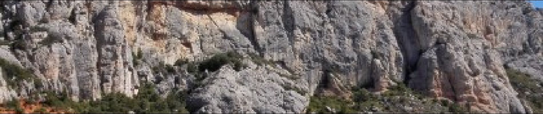
Boucle sur le versant Sud de la Sainte-Victoire qui permet une montée jusqu'aux crêtes par la Marbrière et la brèche du Clapier. Le cheminement en crêtes permet d'avoir des points de vue magnifiques avec en ligne de mire la Croix de Provence. Descente par le prieuré, le Pas du Berger et le refuge Cézanne.
Commentaire sur Visorando:

Elevation profile

Photos

Points of interest

Point of interest Saint-Antonin-sur-Bayon - Parking des 2 Aiguilles - Photo
ARVIEU
SAINT-ANTONIN-SUR-BAYON 
Point of interest Saint-Antonin-sur-Bayon - À droite sur le balisage Marron - Photo
ARVIEU
SAINT-ANTONIN-SUR-BAYON 
Point of interest Saint-Antonin-sur-Bayon - À gauche sur le balisage Vert - Photo
ARVIEU
SAINT-ANTONIN-SUR-BAYON 
Point of interest Saint-Antonin-sur-Bayon - À gauche sur le GR9 - Photo
ARVIEU
SAINT-ANTONIN-SUR-BAYON 
Point of interest Saint-Antonin-sur-Bayon - À gauche sur le balisage Marron - Photo
ARVIEU
SAINT-ANTONIN-SUR-BAYON 
Point of interest Saint-Antonin-sur-Bayon - À droite sur le balisage Jaune - Photo
ARVIEU
SAINT-ANTONIN-SUR-BAYON 
Point of interest Saint-Antonin-sur-Bayon - Parking des 2 Aiguilles - Photo
ARVIEU
SAINT-ANTONIN-SUR-BAYON 

Positioning

Country:
France
Region :
Provence-Alpes-Côte d'Azur
Department/Province :
Bouches-du-Rhône
Municipality :
Saint-Antonin-sur-Bayon
Location:
Unknown
Start:(UTM)
709220 ; 4821896 (31T) N.

Trails nearby

Trail Walking Saint-Antonin-sur-Bayon - Ste Victoire - Le Garagaï - Photo
Walking
ETMU5496

Walking

Difficult
(1)
Saint-Antonin-sur-Bayon, Provence-Alpes-Côte d'Azur, Bouches-du-Rhône, France
15.8 km | 28 km-effort
4h 36min
Yes
Trail Walking Saint-Marc-Jaumegarde - Barrages Zola-Bimont - Photo
Walking
Berpav

Walking

Medium
(2)
Saint-Marc-Jaumegarde, Provence-Alpes-Côte d'Azur, Bouches-du-Rhône, France
8 km | 11 km-effort
2h 30min
Yes
Trail Walking Vauvenargues - Le Signal, Montagne Sainte-Victoire - Photo
Walking
tracegps

Walking

Medium
(2)
Vauvenargues, Provence-Alpes-Côte d'Azur, Bouches-du-Rhône, France
15 km | 25 km-effort
6h 19min
Yes
Trail Walking Saint-Marc-Jaumegarde - La Croix de Provence depuis le barrage de Bimont - Photo
Walking
tracegps

Walking

Difficult
(1)
Saint-Marc-Jaumegarde, Provence-Alpes-Côte d'Azur, Bouches-du-Rhône, France
13.9 km | 24 km-effort
4h 45min
Yes
Trail Walking Saint-Antonin-sur-Bayon - 2023-02-10 Sainte Victoire Bau des Vespres - Photo
Walking
GUIDE
Kargil

Walking

Difficult
Saint-Antonin-sur-Bayon, Provence-Alpes-Côte d'Azur, Bouches-du-Rhône, France
10 km | 18.8 km-effort
3h 30min
Yes
Trail On foot Vauvenargues - Sentier des Venturiers - Photo
On foot
PRO

On foot

Easy
Vauvenargues, Provence-Alpes-Côte d'Azur, Bouches-du-Rhône, France
5 km | 10.5 km-effort
2h 23min
No
Trail On foot Beaurecueil - Sentier Imoucha - Photo
On foot
PRO

On foot

Easy
Beaurecueil, Provence-Alpes-Côte d'Azur, Bouches-du-Rhône, France
4.4 km | 10.1 km-effort
2h 17min
No
Trail Walking Saint-Antonin-sur-Bayon - pas du clapier et tracé vert - Photo
Walking
GUIDE
amiral13

Walking

Difficult
Saint-Antonin-sur-Bayon, Provence-Alpes-Côte d'Azur, Bouches-du-Rhône, France
10.5 km | 21 km-effort
5h 24min
Yes
Trail Walking Saint-Antonin-sur-Bayon - Sainte Victoire - Bau Cézanne - tracé jaune - Photo
Walking
GUIDE
amiral13

Walking

Difficult
(1)
Saint-Antonin-sur-Bayon, Provence-Alpes-Côte d'Azur, Bouches-du-Rhône, France
5.3 km | 12.2 km-effort
2h 28min
Yes


Close
My subscriptions