Trail Motor Veynes - D04 - Les Ecrins, le Champsaur et le Dévoluy - Photo

D04 - Les Ecrins, le Champsaur et le Dévoluy

Les Hautes Alpes à découvrir ! GUIDE+

© OpenStreetMap contributors
Length
Length
149 km
Max alt
Max alt
1688 m
Uphill gradient
Uphill gradient
3117 m
Km-Effort
Km-Effort  
190 km
Min alt
Min alt
736 m
Downhill gradient
Downhill gradient
3117 m
Boucle
Boucle
Yes
Creation date :
2018-03-23 05:39:40.676
Updated on :
2018-11-13 09:27:48.201

(0 Reviews)

Motor
Motor
4h00
Difficulty : Unknown

Scan this QR Code to open this trail in the SityTrail application

FREE GPS app for hiking

Logo SityTrail SityTrail

IGN / Geographical institutes

Download SityTrail from the App Store Download SityTrail from Google Play

Logo SityTrail SityTrail World

The world is yours!

Download SityTrail from the App Store Download SityTrail from Google Play Download SityTrail on Huawei AppGallery

About

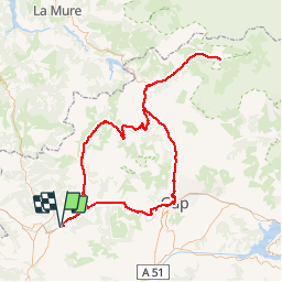
Trail Motor of 149 km to be discovered at Provence-Alpes-Côte d'Azur, Hautes-Alpes, Veynes. This trail is proposed by Camping Les Rives du Lac.

Description

Un magnifique tour qui vous permettra de voir trois massifs complètement différents : Champsaur, Ecrins et Dévoluy.
Plusieurs haltes indispensables bien entendu, comme les cols du Noyer et du Festre, le défilé des Etroits, la Chapelle en Valgaudemard. Chaque fois, il est possible de faire une petite marche pour mieux profiter du paysage.

Elevation profile

Points of interest

Point of interest Le Dévoluy - Col du Festre - Photo
CampingLesRivesduLac
LE DÉVOLUY 
Point of interest Le Noyer - Le Col de Noyer - Photo
CampingLesRivesduLac
LE NOYER 
Point of interest La Chapelle-en-Valgaudémar - Le Valgaudemard - Photo
CampingLesRivesduLac
LA CHAPELLE-EN-VALGAUDÉMAR 
Point of interest Le Dévoluy - Les étroits - Photo
CampingLesRivesduLac
LE DÉVOLUY 

Positioning

Country:
France
Region :
Provence-Alpes-Côte d'Azur
Department/Province :
Hautes-Alpes
Municipality :
Veynes
Location:
Unknown
Start:(Dec)
Start:(UTM)
722408 ; 4933341 (31T) N.

Trails nearby

Trail Walking Le Saix - R08 La boucle des cascades jaunes - Photo
Walking
GUIDE+

Walking

Very easy
(1)
Le Saix, Provence-Alpes-Côte d'Azur, Hautes-Alpes, France
5.5 km | 10.3 km-effort
2h 10min
Yes
Trail Mountain bike Veynes - VTT29 - Rando famille - Photo
Mountain bike
GUIDE+

Mountain bike

Easy
(1)
Veynes, Provence-Alpes-Côte d'Azur, Hautes-Alpes, France
10.9 km | 13.6 km-effort
54min
Yes
Trail Mountain bike Veynes - VTT14 - Les crêtes de la Longeagne - Photo
Mountain bike
GUIDE+

Mountain bike

Very difficult
(1)
Veynes, Provence-Alpes-Côte d'Azur, Hautes-Alpes, France
39 km | 57 km-effort
3h 15min
Yes
Trail Mountain bike Veynes - VTT03 - Tous les Eygaux - Photo
Mountain bike
GUIDE+

Mountain bike

Medium
(2)
Veynes, Provence-Alpes-Côte d'Azur, Hautes-Alpes, France
23 km | 31 km-effort
1h 31min
Yes
Trail Mountain bike Veynes - VTT02 - Aiguebelle - Photo
Mountain bike
GUIDE+

Mountain bike

Easy
(2)
Veynes, Provence-Alpes-Côte d'Azur, Hautes-Alpes, France
16.7 km | 21 km-effort
1h 23min
Yes
Trail Mountain bike Veynes - VTT01 - Les Eygaux - Photo
Mountain bike
GUIDE+

Mountain bike

Easy
(3)
Veynes, Provence-Alpes-Côte d'Azur, Hautes-Alpes, France
14.1 km | 19.2 km-effort
1h 13min
Yes
Trail Walking Veynes - R10   Le tour des Eygaux - Photo
Walking
GUIDE+

Walking

Very easy
(4)
Veynes, Provence-Alpes-Côte d'Azur, Hautes-Alpes, France
7.8 km | 11.3 km-effort
2h 24min
Yes
Trail Walking Veynes - R09   Le tour de Veynes - Photo
Walking
GUIDE+

Walking

Very easy
(3)
Veynes, Provence-Alpes-Côte d'Azur, Hautes-Alpes, France
9.5 km | 12.3 km-effort
2h 40min
Yes
Trail Walking Le Saix - R07   le fai - Photo
Walking
GUIDE+

Walking

Easy
(4)
Le Saix, Provence-Alpes-Côte d'Azur, Hautes-Alpes, France
5.1 km | 8 km-effort
1h 42min
Yes


Close
My subscriptions