Trail Snowshoes Sondernach - Traversée des Vosges en raquettes - Étape 3 - de Rhotenbrunnen à Soultzeren - Photo

Traversée des Vosges en raquettes - Étape 3 - de Rhotenbrunnen à Soultzeren

 tracegps
tracegps

User

© OpenStreetMap contributors
Length
Length
13.2 km
Max alt
Max alt
1164 m
Uphill gradient
Uphill gradient
210 m
Km-Effort
Km-Effort  
18.1 km
Min alt
Min alt
380 m
Downhill gradient
Downhill gradient
836 m
Boucle
Boucle
No
Creation date :
2014-12-10 00:00:00.0
Updated on :
2014-12-10 00:00:00.0

(0 Reviews)

Snowshoes
Snowshoes
3h30
Difficulty : Difficult

Scan this QR Code to open this trail in the SityTrail application

FREE GPS app for hiking

Logo SityTrail SityTrail

IGN / Geographical institutes

Download SityTrail from the App Store Download SityTrail from Google Play

Logo SityTrail SityTrail World

The world is yours!

Download SityTrail from the App Store Download SityTrail from Google Play Download SityTrail on Huawei AppGallery

About

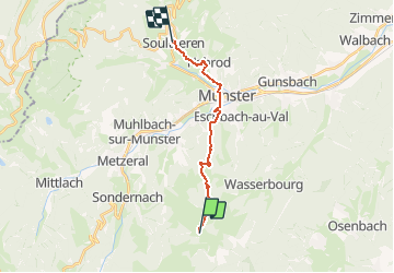
Trail Snowshoes of 13.2 km to be discovered at Grand Est, Haut-Rhin, Sondernach. This trail is proposed by tracegps.

Description

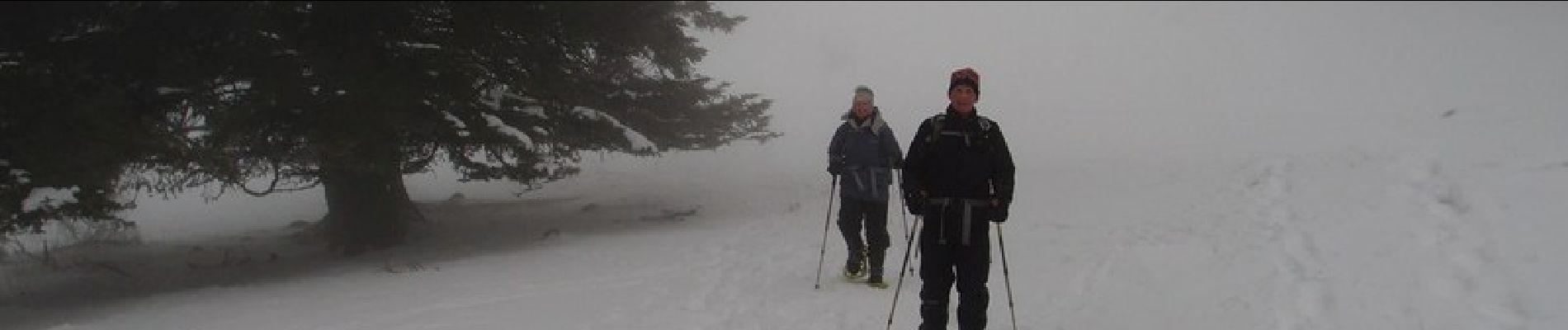
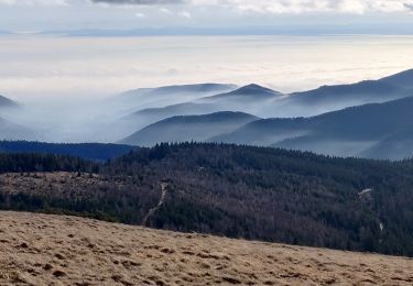
Ce matin, ce n’est plus la même affaire : le brouillard est tel que nous devons rester groupés pour ne pas se perdre de vue et sans l’aide du GPS nous aurions eu le plus grand mal à trouver le point de départ de notre randonnée. Pas question de s’écarter de la trace. Nous avançons l’œil rivé aux instruments et aidés par la présence de traces de raquettes faites les jours précédents. Le chien de la ferme nous accompagne, longtemps. Il faut se fâcher, le menacer pour qu’il consente à cesser de nous suivre. Penaud, il va se coucher dans la neige pour nous regarde partir. Nous descendons en fond de vallée et il faut attendre d’arriver pratiquement à mi-pente pour commencer à découvrir un peu le panorama qui nous entoure. Passé ce point, la visibilité est bonne mais les paysages atones semblent anesthésiés. Le sentier mène à Munster où nous faisons une longue pause-repas parce qu’il ne nous reste plus beaucoup de chemin à parcourir avant la fin de notre étape. La dernière partie est presque une formalité. Nous arrivons tôt à Soultzeren. L’après-midi est encore loin d’être terminé et le village ne présente pas beaucoup d’attrait. On y fait néanmoins une petite balade sans grand enthousiasme. C’est une enfilade de maisons le long d’une route en pente qui mène au Col de la Schlucht. Une aubaine pour les restaurateurs, une plaie pour les riverains. Pour plus d’informations, retrouvez les conseils pratiques sur cette randonnée.

Elevation profile

Photos

Positioning

Country:
France
Region :
Grand Est
Department/Province :
Haut-Rhin
Municipality :
Sondernach
Location:
Unknown
Start:(UTM)
359681 ; 5316084 (32T) N.

Trails nearby

Trail Walking Lautenbach - Tour du Petit Ballon - Photo
Walking
VacheKiri67

Walking

Medium
(1)
Lautenbach, Grand Est, Haut-Rhin, France
12.7 km | 20 km-effort
4h 46min
Yes
Trail Walking Linthal - Tour de la grande Vallée de Munster (refuge du Hilsen - Munster) - Photo
Walking
tracegps

Walking

Difficult
(1)
Linthal, Grand Est, Haut-Rhin, France
18.1 km | 24 km-effort
5h 0min
No
Trail Walking Lautenbachzell - Le Markstein - Photo
Walking
tracegps

Walking

Difficult
(1)
Lautenbachzell, Grand Est, Haut-Rhin, France
22 km | 35 km-effort
6h 0min
Yes
Trail Mountain bike Metzeral - Sentier des Névés - Photo
Mountain bike
tracegps

Mountain bike

Very difficult
(1)
Metzeral, Grand Est, Haut-Rhin, France
33 km | 52 km-effort
6h 0min
Yes
Trail Walking Linthal - SityTrail - Remspach-Hilsen - Photo
Walking

Walking

Medium
(1)
Linthal, Grand Est, Haut-Rhin, France
9.9 km | 14.6 km-effort
3h 3min
Yes
Trail On foot Wasserbourg - Boenlesgrab - Drei Schöpf - Bannwald - Chalet St Hubert - Brunnemaëttlé - Wassmatt - Hansen et retour - Photo
On foot
patrickbeyrath

On foot

Medium
(1)
Wasserbourg, Grand Est, Haut-Rhin, France
10.2 km | 14.2 km-effort
Unknown
Yes
Trail Walking Wasserbourg - SityTrail - Boenlesgrab- Strohberg - Photo
Walking

Walking

Difficult
(1)
Wasserbourg, Grand Est, Haut-Rhin, France
9.6 km | 15.1 km-effort
3h 0min
Yes
Trail Walking Sondernach - 2020-01-02 Marche Landersen Petit Ballon - Photo
Walking
GUIDE
holtzv

Walking

Difficult
Sondernach, Grand Est, Haut-Rhin, France
17.6 km | 28 km-effort
3h 4min
Yes
Trail Walking Wasserbourg - Autour de Wasserbourg - Photo
Walking
bob68

Walking

Easy
(1)
Wasserbourg, Grand Est, Haut-Rhin, France
8.8 km | 14 km-effort
2h 6min
Yes


Close
My subscriptions