Trail Mountain bike Saint-Aventin - 14 Arbesquens - Photo
 ray23
ray23

User

© OpenStreetMap contributors
Length
Length
9.4 km
Max alt
Max alt
1796 m
Uphill gradient
Uphill gradient
23 m
Km-Effort
Km-Effort  
13.6 km
Min alt
Min alt
635 m
Downhill gradient
Downhill gradient
1182 m
Boucle
Boucle
No
Creation date :
2014-12-10 00:00:00.0
Updated on :
2014-12-10 00:00:00.0

(0 Reviews)

Mountain bike
Mountain bike
34m
Difficulty : Difficult

Scan this QR Code to open this trail in the SityTrail application

FREE GPS app for hiking

Logo SityTrail SityTrail

IGN / Geographical institutes

Download SityTrail from the App Store Download SityTrail from Google Play

Logo SityTrail SityTrail World

The world is yours!

Download SityTrail from the App Store Download SityTrail from Google Play Download SityTrail on Huawei AppGallery

About

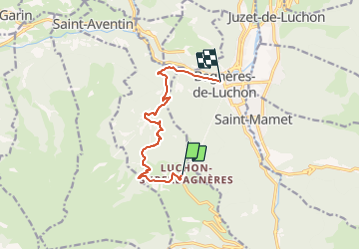
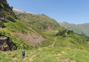
Trail Mountain bike of 9.4 km to be discovered at Occitania, Haute-Garonne, Saint-Aventin. This trail is proposed by ray23.

Description

Starting at SuperBagneres 1800m, down through the ski station and then technical single track through forest

Elevation profile

Positioning

Country:
France
Region :
Occitania
Department/Province :
Haute-Garonne
Municipality :
Saint-Aventin
Location:
Unknown
Start:(UTM)
301748 ; 4737911 (31T) N.

Trails nearby

Trail Snowshoes Juzet-de-Luchon - JUZET - PAS DE LA COMBE (LABACH) - Photo
Snowshoes
Marcocroco

Snowshoes

Medium
(1)
Juzet-de-Luchon, Occitania, Haute-Garonne, France
7.1 km | 12.5 km-effort
2h 33min
Yes
Trail Walking Saint-Mamet - Fonds de Burbe - Saint Mamet - Photo
Walking
tracegps

Walking

Difficult
(1)
Saint-Mamet, Occitania, Haute-Garonne, France
15.6 km | 27 km-effort
4h 0min
Yes
Trail Mountain bike Saint-Aventin - Luchon Kbour - Photo
Mountain bike
tracegps

Mountain bike

Very difficult
(1)
Saint-Aventin, Occitania, Haute-Garonne, France
11 km | 16.7 km-effort
1h 0min
No
Trail On foot Castillon-de-Larboust - Lac Vert, Boucle par l'Est - Photo
On foot
PRO

On foot

Easy
Castillon-de-Larboust, Occitania, Haute-Garonne, France
8.8 km | 19.5 km-effort
4h 26min
No
Trail Walking Bagnères-de-Luchon - GR 10 - 3 - Photo
Walking
loic09

Walking

Medium
(2)
Bagnères-de-Luchon, Occitania, Haute-Garonne, France
250 km | 489 km-effort
89h 8min
No
Trail Walking Saint-Aventin - Cabane de Courreau en boucle depuis St Aventin  - Photo
Walking
GUIDE
lhomme.ph

Walking

Medium
Saint-Aventin, Occitania, Haute-Garonne, France
13.3 km | 24 km-effort
6h 10min
Yes
Trail Walking Castillon-de-Larboust - Cabane de la Coume - Photo
Walking
swp648

Walking

Difficult
Castillon-de-Larboust, Occitania, Haute-Garonne, France
9.1 km | 18.4 km-effort
3h 39min
Yes
Trail Walking Bagnères-de-Luchon - 2022 08 -Transpyrénéen 2 : Bagnères de Luchon -Fos - Photo
Walking
LEGUE

Walking

Very difficult
Bagnères-de-Luchon, Occitania, Haute-Garonne, France
30 km | 55 km-effort
7h 8min
No
Trail Walking Castillon-de-Larboust - lacs vert et bleu en boucle - Photo
Walking
chrisgps

Walking

Difficult
Castillon-de-Larboust, Occitania, Haute-Garonne, France
15.2 km | 32 km-effort
9h 17min
Yes


Close
My subscriptions